 | 09 Sep 2024
Sediment dynamics of a major piedmont glacier: the Salzach Glacier in the North Alpine Foreland
Bernhard Salcher
Reinhard Starnberger
Thomas Pollhammer
Joachim Götz
Salcher, B., Starnberger, R., Pollhammer, T., and Götz, J.: Sediment dynamics of a major piedmont glacier: the Salzach Glacier in the North Alpine Foreland, DEUQUA Spec. Pub., 5, 31–39, https://doi.org/10.5194/deuquasp-5-31-2024, 2024.
The foreland basins of the European Alps were repeatedly covered by major piedmont glaciers during Quaternary glacial maxima. The Salzach Glacier was the easternmost of a series of large Pleistocene piedmont glaciers entering the North Alpine Foreland through major Alpine valleys. It covered an area of more than 1000 km2 during at least four glacial maxima. The slightly elevated molasse bedrock provides a high potential for preservation of glacial landforms and offers an ideal setting to explore the erosional and depositional dynamics of a major glacier piedmont lobe. This field excursion guide leads to some selected key sites representing deposits of glacial advance, relative equilibrium, and ice lobe collapse.
- Article
(11066 KB) - Full-text XML
- BibTeX
- EndNote


Quaternary landforms in the foreland basins of the European Alps record the impact of significant depositional and erosional processes associated with the dynamics of major piedmont glaciers. In the region between the Rhine Graben and the Bohemian Massif, individual glaciers along the mountain range reached areal extents comparable e.g. to the modern Malaspina piedmont glacier (Alaska Range). Between the Rhine Graben and the Bohemian Massif, at least four glaciation events with relatively similar spatial extents are indicated from landforms and terminal moraines. These periods are locally referred to as (from oldest to youngest) Günz, Mindel, Riss, and Würm (Penck and Brückner, 1909). Numerical age calculations for landforms that formed during the most recent two events suggest a close correlation with the global maximum of the last (Last Glacial Maximum, LGM) and penultimate (Penultimate Glacial Maximum, PGM) periods of glaciation (e.g. Ivy-Ochs et al., 2022a, b). Landforms and outwash deposits related to the older two glacial maxima, Günz and Mindel, have so far not been successfully dated but are assumed to fall in the time periods of Marine Isotope Stage (MIS) 16 and 12 respectively (e.g. Raymo, 1997; van Husen and Reitner, 2011, 2022).
The Bavarian and Austrian parts of the Alpine Molasse basin provide particularly good conditions for glacial landform preservation. Glacial deposits sit on (glacially) flattened and slightly elevated molasse bedrock and host only small, low-order catchments with a low potential for fluvial erosion. Major fluvial processes are focused along the Alpine Danube tributaries (e.g. Salzach), which have also been partly overdeepened by the glaciers. Furthermore, there was sufficient space for the full development of the piedmont major lobes. This, in combination with slightly decreasing extensions of glacier lobes during successive glacial maxima, offers the opportunity to explore landforms of three glacial maxima that predate the LGM.
This field excursion guide presents visits to glacial features which record the erosional and depositional dynamics associated with the advance and meltdown of a major glacial piedmont lobe, the Salzach Glacier (Fig. 1). The sequence of stops will provide insights into the temporal succession of processes, from ice build-up through maximum ice expansion and ice wastage at the onset of global climate relaxation, and finally analyses the effects of postglacial landscape dynamics in a deglaciated foreland region.
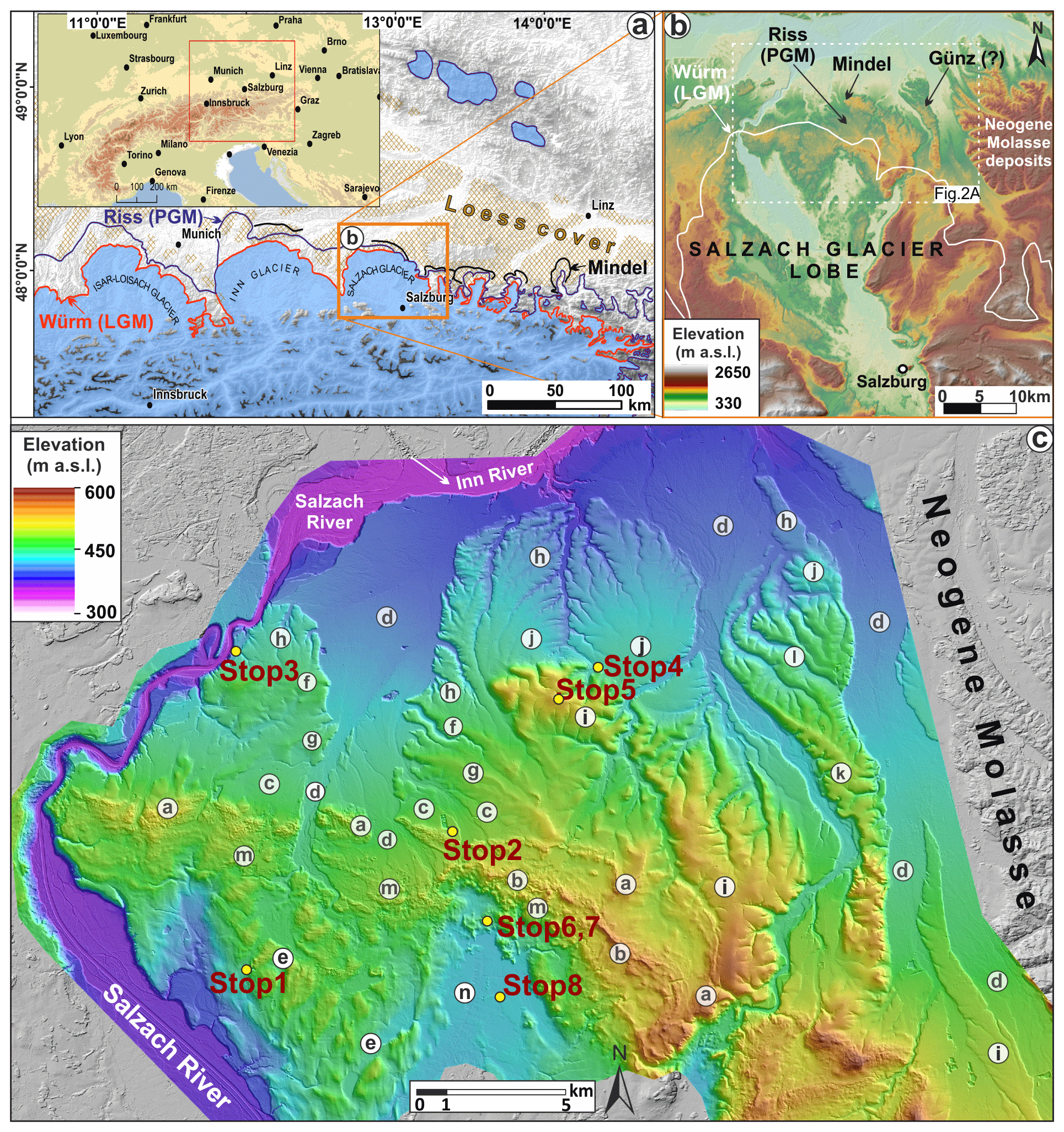
Figure 1(a) Extent of the Salzach Glacier lobe in the North Alpine Foreland during full-glacial periods of the Last Glacial Maximum (LGM; “Würm”), the penultimate glacial maximum (PGM; “Riss”), and the antepenultimate maximum (“Mindel”, correlated to MIS 12; van Husen and Reitner, 2022). (b) Extent of the Salzach Glacier lobe during different glacial maxima and impact on topography. Miocene sediments preserved east of the major piedmont lobes. DEM bases on NASA's SRTM (Shuttle Radar Topography Mission, 90 m; for details see Farr and Kobrick, 2000). Modified from Salcher et al. (2015). (c) Topographic overview, landforms, and planned stops in the field trip. Lowercase letters denote Quaternary landforms. (a) LGM (Würm) terminal moraine 1 (max extent). (b) LGM terminal moraine 2. (c) LGM upper outwash terrace “Obere Niederterrasse” (and sub-terrace levels) associated with terminal moraine 1. (d) LGM lower outwash terrace “Untere Niederterrasse” (and sub-terrace levels) associated with terminal moraine 2. (e) Channels of a subglacial drainage system (LGM). (f) Riss terminal moraine 1 (max extent). (g) Riss terminal moraine 2. (h) Riss outwash “Hochterrasse”. (i) Mindel terminal moraine. (j) Mindel outwash terrace “Jüngere Deckenschotter”. (k) Günz terminal moraine. (l) Günz outwash terrace “Ältere Deckenschotter”. (m) LGM ice wastage deposits. (n) Peat bog (Ibmer Moor). DEM resolution is 10 m (resampled from high-resolution airborne lidar; Land Oberösterreich, https://www.data.gv.at/katalog/en/dataset/land-ooe_digitales-gelandemodell-dgm, last access: 6 February 2023; hillshade from https://www.basemap.at/wmts/1.0.0/WMTSCapabilities.xml (via WTMS), last access: 1 June 2024). Landforms according to Kolmer et al. (2008) and Salcher et al. (2010).
The Döstling gravel pit is situated at the eastern slope of the Salzach valley and allows for insights into ca. 30 m thick glacial and glaciofluvial deposits. Deposition of coarse-grained fluvial sediments (upper and lower channel unit) is interpreted as originating from a bedload-dominated stream but regularly providing flow depths large enough for effective sorting (e.g. cross-bedded strata). The interfingering of the fluvial succession (lower unit) with the heavily consolidated basal till on top indicates that these sediments were deposited in the forefield of the advancing Salzach Glacier and later overridden by the ice. Rare occurrence of laminated fines within basal till may point to uncoupling of the ice from the bed, giving rise to melt-out till formation (Fig. 2e). The position of fluvial deposits relatively high up the valley suggests significant filling of the Salzach valley during these periods. Derived optically stimulated luminescence ages (Salcher et al., 2015) indicate that sediments of the lower unit (and thus the interfingered basalt till) were deposited during the penultimate glaciation (Riss glaciation) and left uneroded by the LGM glacier. Ages exceeding the LGM are in principle agreement with the weathering intensity (e.g. Fig. 2g). Absolute ages are thus far not available from the upper channel unit. Thus, it is not clear whether the upper channel unit capped by basal till reflects an oscillation of the PGM glacier or glacial outwash of the advancing stage of the subsequent glaciation (LGM). The LGM glaciation might, however, have at least provided the modification of the glaciofluvial sediments into streamlined bedforms (Fig. 2b; Weinberger, 1952; Salcher et al., 2010).
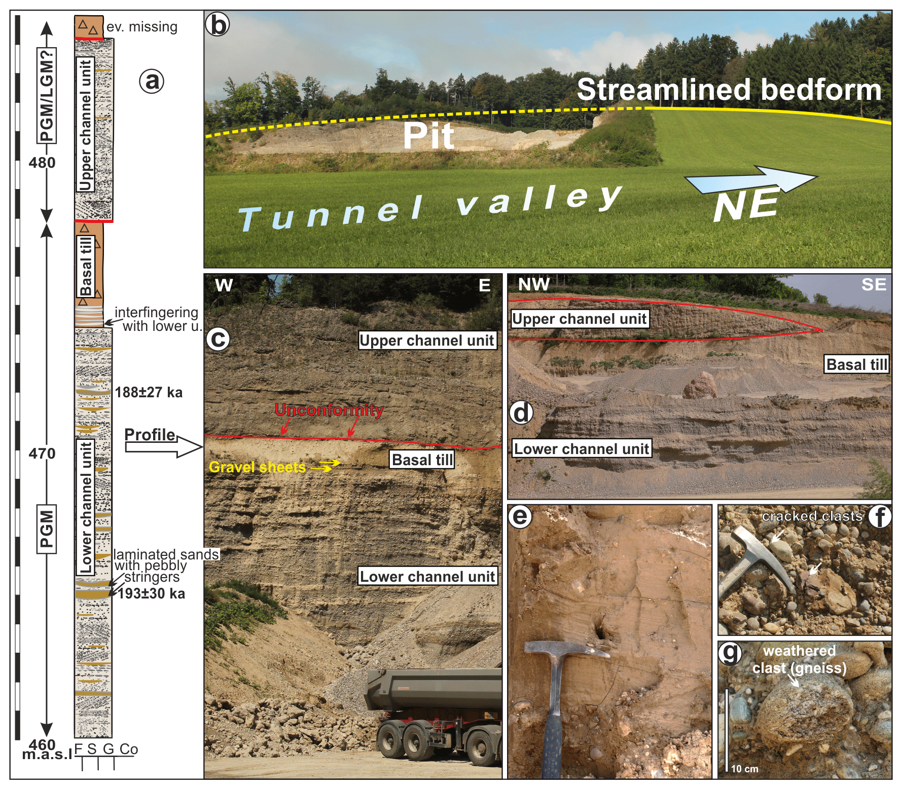
Figure 2(a) Geological profile showing sediments that represent the advancing stage of the Salzach Glacier. Luminescence ages are indicated (Salcher et al., 2015). (b–d) Glaciofluvial deposits (c, d) are capped by basal till and (b) were streamlined by ice flow. (e) Rare occurrence of laminated fines within basal till may point to uncoupling of the ice from the bed, giving rise to melt-out till formation. (f) Clast supported fluvial sediments are prone to cracking trough ice overburden. (g) Relatively high weathering degree of some components is in accordance with depositional ages (PGM). Panels (a) and (b) are modified from Salcher et al. (2015).
This outcrop is situated within fluvial outwash closely related to the terminal moraine of the most extensive advance of the Salzach Glacier during the LGM (Fig. 3b). The terminal moraine of the penultimate glacial maximum (PGM, Riss) can be recognised just north of the outcrop at an altitude of around 500 m a.s.l (above sea level). The outcrop shows a succession of three coarse-grained, massive units (Fig. 3a). These units consisting of non-channelised horizontal bedload sheets are considered to represent deposits of shallow flash floods relating to the upper flow regime (Miall, 1977; Todd, 1989). Supercritical sheetfloods are typical of alluvial fans (Nemec and Postma, 1993; Blair and McPherson, 1994) e.g. associated with a glacier, such as ice contact fans (Fig. 2b) or ramps (Benn and Evens, 1998; Krzyszkowski and Zielinski, 2002). The lowest sheetflood unit is separated from the middle sheetflood unit by a ca. 3–4 m thick layer of basal till. While there is a clear unconformity between the basal till and the middle sheetflood unit above, the transition from the lower sheetflood unit to the basal till is indistinct and marked by gravel sheets intercalated within the till (similar to the situation observed at “Döstling”; Stop 1, Fig. 2). The sequence refers to ice proximity and glacier coverage. The depositional context and luminescence ages suggest that these sediments were deposited during the penultimate glaciation (Riss, MIS 6). If not eroded, the top decimetres of the middle sheetflood unit may appear altered into a brownish–dark-reddish paleosol. It may also form distinct wedge-shaped structures (up to ca. 3 m) referring to periglacial features (i.e. ice wedge casts; see Salcher et al., 2015). The intensively weathered paleosol might have been mainly formed during the Riss–Würm interglacial period (Eemian). Just below the paleosol, sediment may locally appear cemented to conglomerates of decimetres in diameter. The absence of any weathering of the upper sheetflood unit agrees with the derived LGM age.
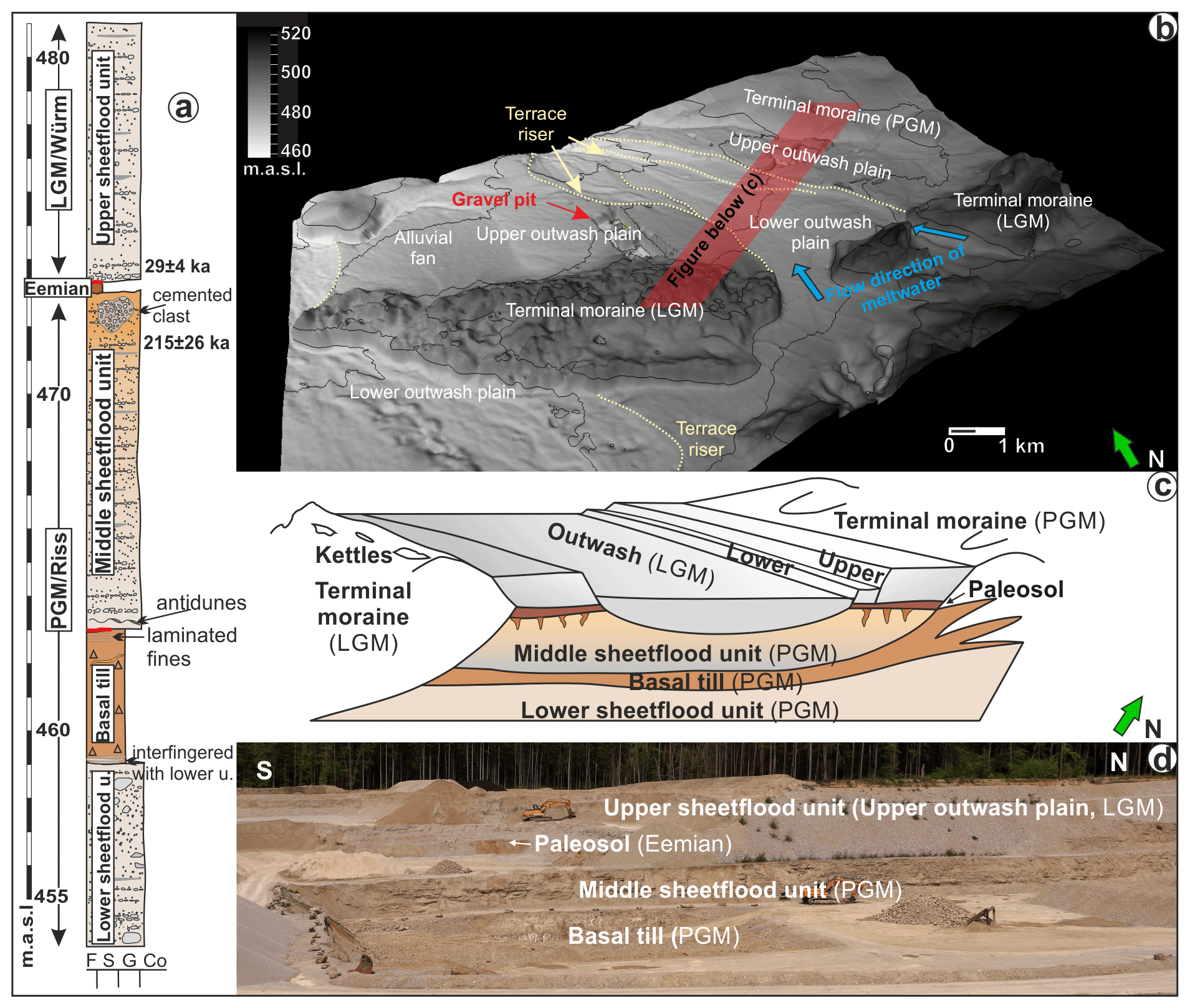
Figure 3(a) Stratigraphic profile of the outcrop “Pfaffinger” indicating some observed features and the position of derived luminescence data. See (b) for the position. (b) Topography near the terminus of the Salzach Glacier lobe. The gravel pit is located within outwash associated with the terminal moraine of the most extensive position of the LGM (terminal moraine 1; see also Fig. 2). The red bar denotes the geological 3D profile shown in (c). (c) Sketch illustrating the stratigraphy of Würmian (LGM) and Rissian (PGM) deposits. Outwash gravel deposited during the advancing stage of the Riss period was later overridden by the glacier as indicated by the basal till. Later, during ice collapse at the end of the Riss period (Termination II), outwash was deposited on top of the basal till. These sediments were subjected to intense soil-forming processes (last interglacial paleosol) and occasionally covered by loess. The sketch is in good accordance with the glacial-series model of Penck and Brückner (1909). Modified from Salcher et al. (2015). (d) Outcrop overview as of April 2024. DEM resolution is 1 m (Land Oberösterreich, http://data.ooe.gv.at, last access: 16 July 2024).
Stop 3 (Ach) is located vis-à-vis Burghausen Castle. The position shows the altitudinal contrast in streamflow elevation of the Salzach River between full-glacial and interglacial (present) conditions (ca. 100 m). Numerous terrace steps nicely mark the successive incision of the river during deglaciation (Termination I; Fig. 4). Glacier retreat and associated fluvial incision must have been extraordinary rapid as glaciers were already at inner-Alpine positions at around 17–18 ka (e.g. Starnberger et al., 2011; Ivy-Ochs et al., 2023). Modern stream level located just above the Neogene bedrock suggests that the incision into sediments that were mainly accumulated during the LGM has largely ceased.
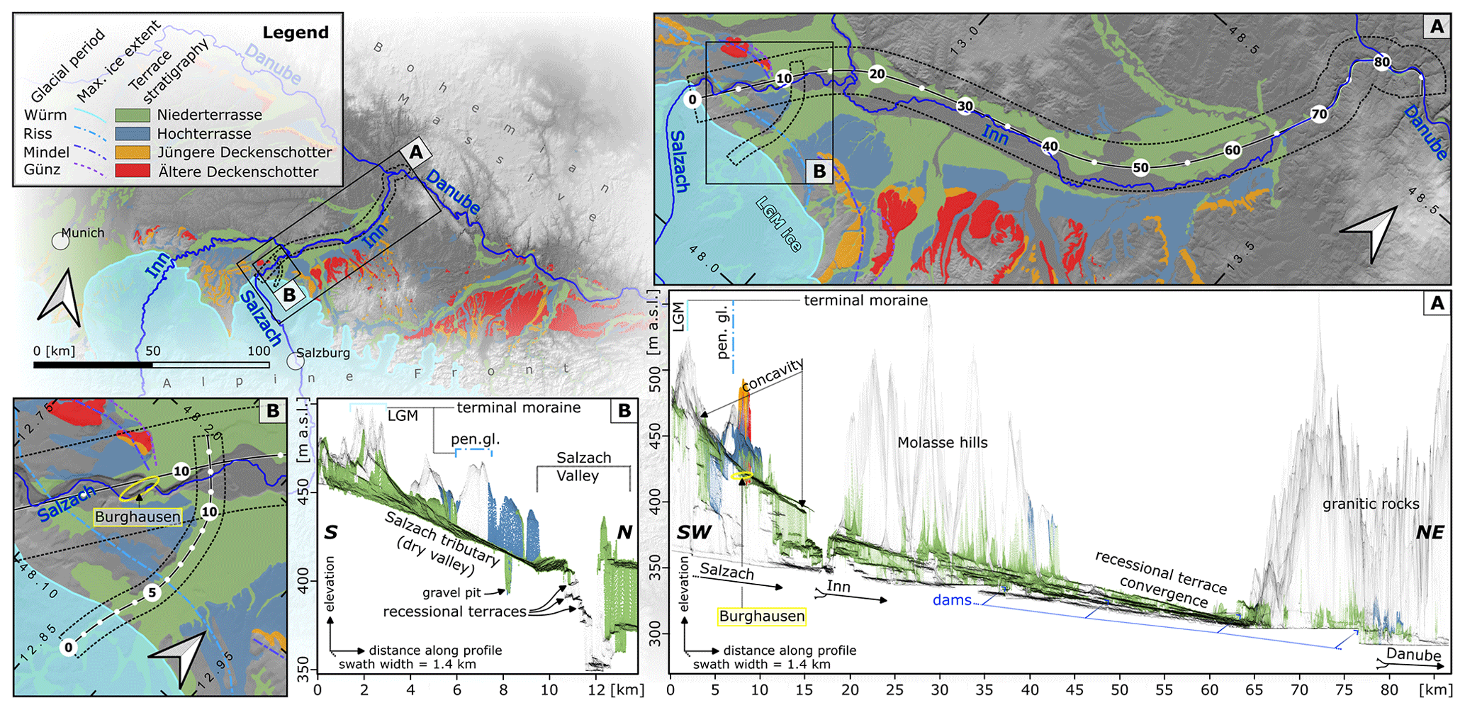
Figure 4Longitudinal swath profile along the Salzach–Inn (A). Digital topographic data (10 m resolution) are orthogonally projected onto the profile line (black) within the marked swath (dashed black lines; see map views). Fill terraces in glaciofluvial outwash of the LGM (Niederterrasse, green colour) were created during glacier meltdown and the lowering of the outwash source (glacier terminus). Close to the LGM terminal moraine, top slopes reach up to > 10 ‰. Glacier retreat and associated lowering of the glacier terminus led to the decrease in profile slopes. In contrast to terraces of different glacial maxima, recessional levels converge at the same altitude. Profile (B) shows the topography of the main outwash plain, which was active during the full extent of the Salzach Glacier during the LGM (terminal moraine 1, 2). Slightly different outwash slopes reflect different LGM positions. With the onset of deglaciation and glacier recession towards the Salzach valley, this outwash plain got quickly abandoned and laterally cut ca. at kilometre marker 10. DEM resampled from Land Oberösterreich (https://www.data.gv.at/katalog/en/dataset/land-ooe_digitales-gelandemodell-dgm).
Glaciofluvial sediments associated with Mindel glaciation are referred to as Jüngere Deckenschotter. These glaciofluvial gravels often appear as erosional remnants with restricted spatial extent and are typically characterised by a high degree of cementation (e.g. van Husen, 2000). Pipe-like structures representing zones of focused weathering (“Geologische Orgeln”) are furthermore typical (e.g. Lempe, 2012) but not obvious in this outcrop. Both the high degree of cementation and the intense weathering are a function of time and the relatively high content of carbonate clasts (acting as source of dissolution and subsequent carbonate precipitation). The sedimentary setting reflects a dynamic ice marginal environment with features of the lower- and higher-flow regime. The cave-like appearance of this outcrop seems at least to be partly natural. This is suggested by the recent discovery of a cave (total length of ca. 20 m) by mining activities in the adjacent gravel pit about 200 m to the west. Radiometric age constraints of Mindel stage deposits are largely absent. Deposits are considered to fall into MIS 12 (van Husen and Reitner, 2011, 2022).

Figure 5Deposits of the Mindel glaciation. (a) Glaciofluvial gravels (“Höhere Deckenschotter”) associated with the Mindel glaciation show horizontal and cross-bedded strata. A highly dynamic setting (like e.g. an ice marginal fan) is suggested by features of the upper flow regime representing antidunes and upper-stage plane beds (b). (c) View from the Mindel terminal moraine (MIS 12?) towards the Alps.
The Mindel glaciation is considered to reflect the most extensive glaciation in the North Alpine Foreland of the Eastern Alps (Penck and Brückner, 1909). Only a few spots suggest terminal moraines outside of this stage (“Günz”). Terminal moraines of the Mindel glaciation generally exceed the width and height of terminal moraines of other glacial maxima by far.
Ice wastage may result in the formation of hummocky moraine and specific landforms like kames or kettle holes comprising a mixture of fluvial, gravitational, and lacustrine deposits. Along the Salzach Glacier lobe, ice wastage deposits are focused in a small area along the former ice margin, commonly not exceeding a width of several hundred metres (cf. Eyles et al., 1999). Glacial recession is often accompanied by the formation of short-lived lakes and local kame delta deposition (Fig. 6). Ephemeral lakes may have formed between the ice margin and e.g. the terminal moraine. The top of a delta surface can thereby refer to the altitude of the former lake level. Ice wastage deposits are often characterised by relatively steep surface slopes (Fig. 6c) which are prone to solifluction and slope failure. The characteristic steep topography is therefore not long lived, and landforms can hardly be recognised outside the limits of the LGM.
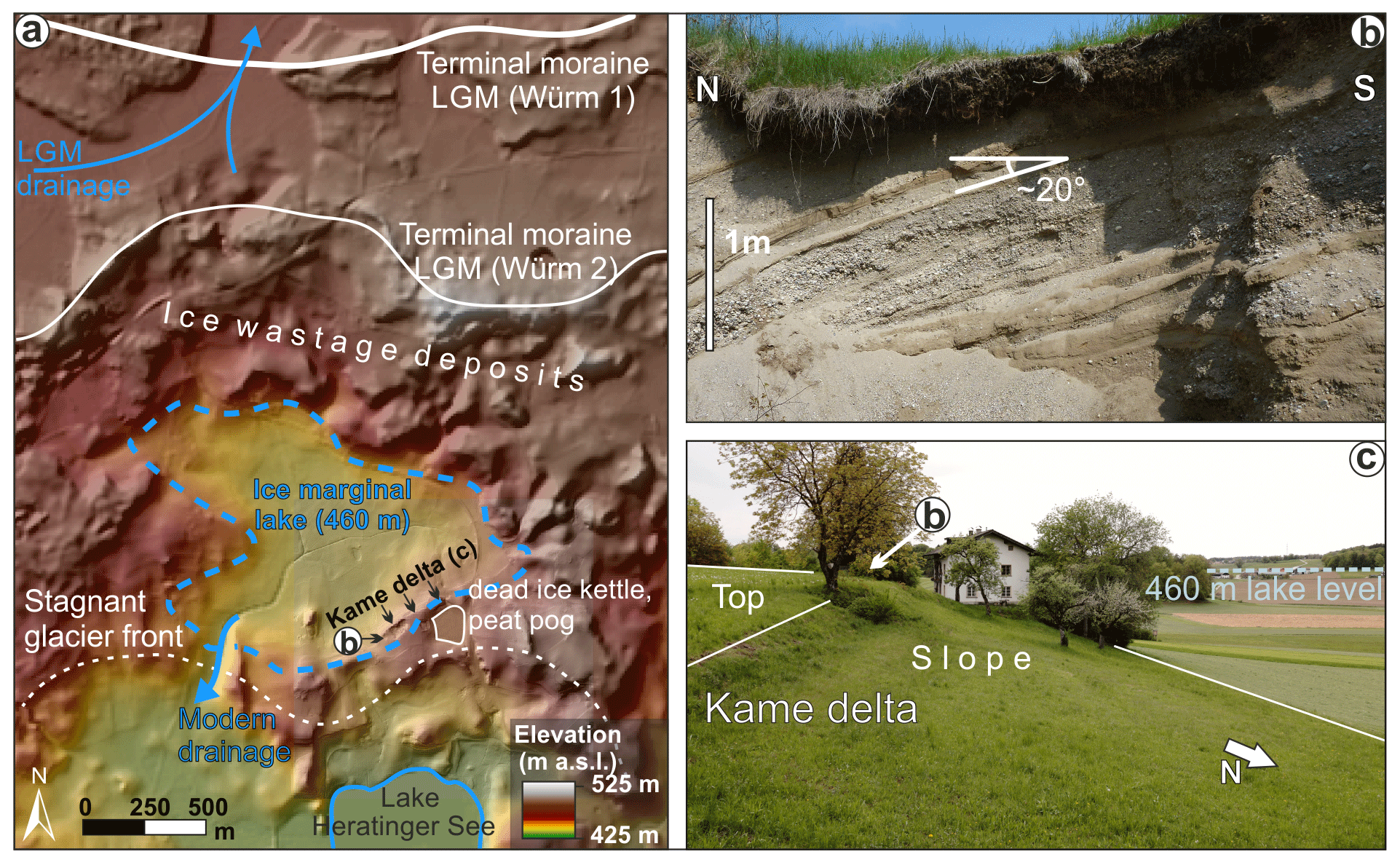
Figure 6(a) Ice wastage deposits are typically represented by small, steeply sloped landforms near the terminal moraines. DEM from Land Oberösterreich (http://data.ooe.gv.at). (b) Foreset of a local kame delta deposit. See (a) for the location. (c) The top of the kame delta marks the former altitude of a short-lived ice marginal lake. The presence of dead ice led to the formation of a large kettle hole. This sink turned into a kettle hole mire (Stop 7).
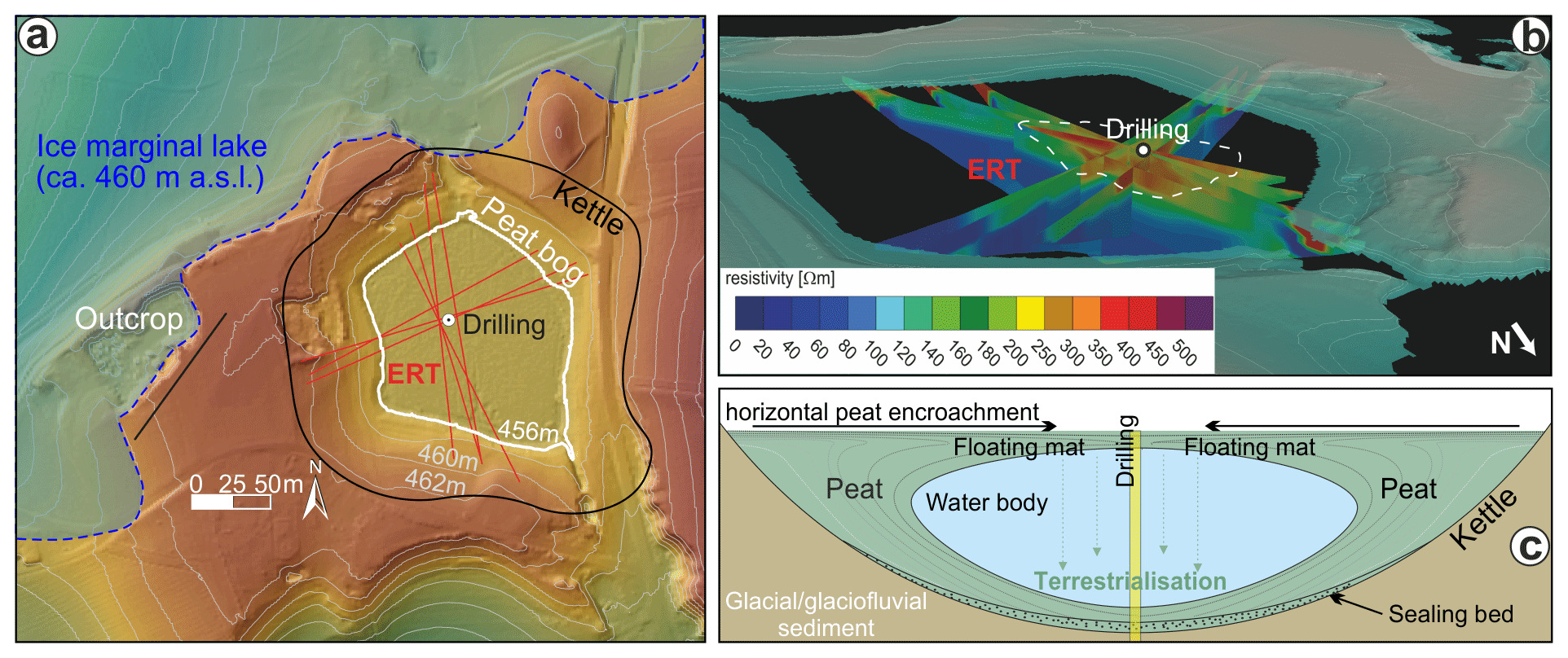
Figure 7(a) Jackenmoos mire formed in a kettle hole of a kame delta (Fig. 6). (b) Distribution of resistivity within the mire is shown by electrical resistivity tomography (ERT). The waterbody is indicated by values of high resistivity referring to a low degree of mineralisation. (c) Concept of floating-mat terrestrialisation after Gaudig et al. (2006) and Götz et al. (2018). The location of the drill core is highlighted as a yellow bar. DEM from Land Oberösterreich (http://data.ooe.gv.at). Modified from Götz et al. (2018).
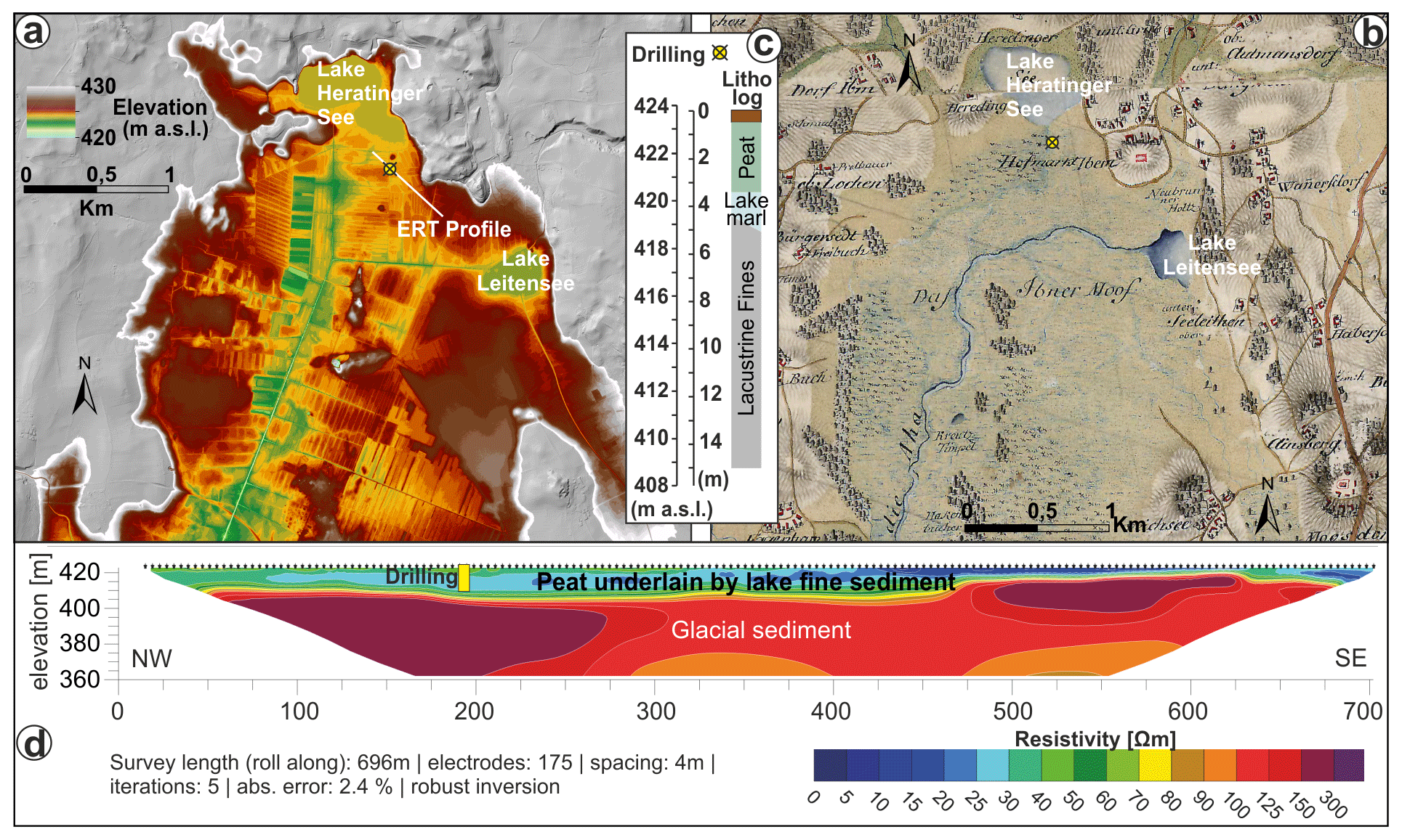
Figure 8(a) Topography of Austria's largest peat bog (Ibmer Moor, northern part). DEM with 0.5 m ground resolution (Land Oberösterreich, http://data.ooe.gv.at) highlights the major anthropogenic overprint through artificial drainage (long linear features of some 100 m) and peat exploitation (rectangular features). (b) First Military Survey (Josephinische Landesaufnahme; 1775–1777) showing approximately the same area as above (a) but with a largely undisturbed environment. Note the modifications to the drainage system. Map is derived from http://mapire.eu (last access: 1 June 2024). (c) Drill log showing the postglacial to Holocene stratigraphy just south of Lake Heratinger See. (d) Electrical resistivity tomography section. Low-resistivity parts (blue–green) indicate the presence of lake fines (clay, lake marls). Higher values (red colours) indicated the presence of coarse-grained glacial sediment. Panel (d) was modified from Götz et al. (2018).
The detachment of ice fragments from the glacier to form dead ice is a common process during meltdown. Sinks or kettle holes can result if dead ice is buried by sediments. They are typically prevalent in terminal moraines (see Fig. 3) or associated with ice wastage deposits. Kettle holes often appear in larger fields with numerous kettles side by side. Depending on sediment and water inflow, these forms may contain (ephemeral) bodies of standing water. Through horizontal or vertical terrestrialisation (small) lakes may also turn into kettle hole mires (Fig. 7). In the process of terrestrialisation waterbodies can be completely covered by a floating vegetation mat and peat (Fig. 7c). The contrast between the floating mat, the waterbody, the underlying material, and the rim of the kettle can be discriminated by electrical resistivity tomography well (Fig. 7b). The unusual high resistivity of the waterbody is a function of low mineralisation.
The “Ibmer Moor” is the largest peat bog area in Austria. This stop on the natural trail gives an overview of some relatively undisturbed parts of the peat bog. While the peat bog in the southern part (located in the federal state of Salzburg) was completely exploited (and thus destroyed), the northern, Upper Austrian part remained better preserved. Large parts of the peat bog formed through late-glacial to Holocene terrestrialisation of a lake that had been left after deglaciation. This process was promoted by the water depth of only a few metres. Climate relaxation is indicated by lake marl deposition often present below the peat. Two small residual lakes are still left from the ongoing process of terrestrialisation (Lake Heratinger See and Lake Leitensee).
DEM data can be accessed via https://www.data.gv.at/katalog/de/dataset/land-ooe_digitales-gelandemodell-dgm (Federal state of Upper Austria, 2024).
BS and RS planned the field trip and the article together. BS made most figures and wrote the major part with contributions from all authors. Figure 4 was entirely made by TP.
At least one of the (co-)authors is a guest member of the editorial board of DEUQUA Special Publications for the special issue “Quaternary landscape dynamics in the Eastern Alps: from the highest peaks to the northern foreland basin – a guidebook to field trips”. The peer-review process was guided by an independent editor, and the authors also have no other competing interests to declare.
Publisher’s note: Copernicus Publications remains neutral with regard to jurisdictional claims made in the text, published maps, institutional affiliations, or any other geographical representation in this paper. While Copernicus Publications makes every effort to include appropriate place names, the final responsibility lies with the authors.
We highly appreciate Ylvie Aranmanoth's field assistance. Furthermore, we thank Noreen Vielreicher for English language corrections in an earlier version of the paper.
This research has been supported by the Paris Lodron University of Salzburg Publication Fund.
Benn, D. I. and Evans, D. J. A.: Glaciers and Glaciations, Arnold, London, ISBN 0-340-58431-0, 1998.
Blair, T. C. and McPherson, J. G.: Alluvial fan processes and their natural distinction from rivers based on morphology, hydraulic processes, sedimentary processes, and facies, J. Sediment. Res., 64A, 450–489, 1994.
Eyles, N., Boyce, J. I., and Barendregt, R. W.: Hummocky moraine: sedimentary record of stagnant Laurentide Ice Sheet lobes resting on soft beds, Sediment. Geol., 123, 163–174, 1999.
Farr, T. G. and Kobrick, M.: Shuttle Radar Topography Mission produces a wealth of data, Eos, Transactions AGU, 81, 583–583, 2000.
Federal state of Upper Austria: Digital elevation model of Upper Austria (0.5 m resolution baseing on airborne laserscan missions), Federal state of Upper Austria (Land Oberösterreich), data.gv.at [data set], https://www.data.gv.at/katalog/en/dataset/land-ooe_digitales-gelandemodell-dgm, last access: 16 July 2024.
Gaudig, G., Couwenberg, J., and Joosten, H.: Peat accumulation in kettle holes: bottom up or top down?, Mires Peat., 1, 1–16, 2006.
Götz, J., Salcher, B. C., Starnberger, R., and Krisai, R.: Geophysical, topographic and stratigraphic analyses of perialpine kettles and implications for postglacial mire formation, Geogr. Ann. A, 100, 254–271, 2018.
Ivy-Ochs, S., Monegato, G., and Reitner, J. M.: The Alps: glacial landforms from the Last Glacial Maximum, in: European Glacial Landscapes, edited by: Palacios, D., Hughes, P. D., García-Ruiz, J. M., and Andrés, N., Chap. 58, 449–460, Elsevier, Amsterdam, the Netherlands, https://doi.org/10.1016/B978-0-12-823498-3.00030-3, 2022a.
Ivy-Ochs, S., Monegato, G., and Reitner, J. M.: The Alps: glacial landforms prior to the Last Glacial Maximum, in: European Glacial Landscapes, edited by: Palacios, D., Hughes, P. D., García-Ruiz, J. M., and Andrés, N., Chap. 39, 283–294, Elsevier, Amsterdam, the Netherlands, https://doi.org/10.1016/B978-0-12-823498-3.00008-X, 2022b.
Ivy-Ochs, S., Monegato, G., and Reitner, J. M.: The Alps: glacial landforms during the deglaciation (18.9–14.6 ka), in: European Glacial Landscapes, edited by: Palacios, D., Hughes, P. D., García-Ruiz, J. M., and Andrés, N., Chap. 20, 175–183, Elsevier, Amsterdam, the Netherlands, https://doi.org/10.1016/B978-0-323-91899-2.00005-X, 2023.
Kolmer, C., van Husen, D., and Salcher, B.: Landschaftsgeschichte und Hydrogeologie der neogenen und quartären Ablagerungen zwischen Mattig und Inn, Amt der oberösterreichischen Landesregierung, Linz, Austria, 243 pp., 2008.
Krzyszkowski, D. and Zielinski, T.: The Pleistocene end moraine fans: controls on their sedimentation and location, Sediment. Geol., 149, 73–92, 2002.
Lempe, B.: Die geologischen Verhältnisse auf der GK25 Blatt Nr. 8027 Memmingen unter besonderer Berücksichtigung der Verwitterungserscheinungen in pleistozänen Schmelzwasserschottern und deren Einfluss auf ihre bautechnischen Eigenschaften. Entwicklung einer Verwitterungsklassifizierung, PhD Thesis, Technische Universität München, 224 pp., http://mediatum.ub.tum.de/node?id=1096718 (last access: 16 May 2024), 2012.
Miall, A. D.: A review of the braided river depositional environment, Earth Sci. Rev., 13, 1–62, 1977.
Nemec, W. and Postma, G.: Quaternary alluvial fans in southwestern Crete: sedimentation processes and geomorphic evolution, in: Alluvial Sedimentation: International Association of Sedimentologists. Special Publication, edited by: Marzo, M. and Puigdefabrogas, C., Blackwell Science, https://doi.org/10.13140/2.1.1535.5521, 1993.
Penck, A. and Brückner, E.: Die Alpen im Eiszeitalter, Tauchnitz, Leipzig, 1909.
Raymo, M. E.: The timing of major climatic terminations, Paleoceanography, 12, 577–585, 1997.
Salcher, B. C., Hinsch, R., and Wagreich, M.: High-resolution mapping of glacial landforms in the North Alpine Foreland, Austria, Geomorphology, 122, 283–293, 2010.
Salcher, B. C., Starnberger, R., and Götz, J.: The last and penultimate glaciation in the North Alpine Foreland: New stratigraphical and chronological data from the Salzach glacier, Quatern. Int., 338, 218–231, 2015.
Starnberger, R., Rodnight, H., and Spötl, C.: Chronology of the Last Glacial Maximum in the Salzach Palaeoglacier Area (Eastern Alps), J. Quaternary Sci., 26, 502–510, 2011.
Todd, S. P.: Stream-driven, high-density gravelly traction carpets: possible deposits in the Trabeg Conglomerate Formation, SW Ireland and some theoretical considerations of their origin, Sedimentology, 36, 513–530, https://doi.org/10.1111/j.1365-3091.1989.tb02083.x, 1989.
van Husen, D.: Geological processes during the Quaternary, Mitteilungen der Österreichische Geologische Gesellschaft, 92, 135–156, 2000.
van Husen, D. and Reitner, J. M.: An Outline of the Quaternary Stratigraphy of Austria, E&G Quaternary Sci. J., 60, 24, https://doi.org/10.3285/eg.60.2-3.09, 2011.
van Husen, D. and Reitner, J. M.: Quaternary System, in: The Lithostratigraphic Units of Austria: Cenozoic Era(them), edited by: Piller, W. E., Geological Survey of Austria, Vienna, 240–267, ISBN 978-3-903252-15-8, 2022.
Weinberger, L.: Ein Rinnensystem im Gebiete des Salzach-Gletschers, Zeitschrift für Gletscherkunde und Glazialgeologie, vol. 2, 1952.
- How to cite
- Abstract
- Introduction
- Stop 1: Döstling gravel pit – the advancing period of the Salzach Glacier lobe (Fig. 2)
- Stop 2: Pfaffinger gravel pit – maximum position of the LGM glacier and evidence for the glacial series (Fig. 3)
- Stop 3: fluvial outwash and postglacial incision (Fig. 4)
- Stop 4: Jüngere Deckenschotter – glaciofluvial outwash of the Mindel glaciation (Fig. 5a, b)
- Stop 5: Mindel terminal moraine (Fig. 5c)
- Stop 6: Termination I – ice wastage and associated landforms (Fig. 6)
- Stop 7: Jackenmoos mire – the formation of kettle holes and its importance for postglacial processes (Fig. 7)
- Stop 8: Ibmer Moor peat bog – natural trail (Fig. 8)
- Data availability
- Author contributions
- Competing interests
- Disclaimer
- Acknowledgements
- Financial support
- References