 | 15 Sep 2022
Quaternary and geoarcheology in Lower Lusatia
Florian Hirsch
Alexandra Raab
Anna Schneider
Alexander Bonhage
Marcus Schneider
Albrecht Bauriegel
Hirsch, F., Raab, T., Raab, A., Schneider, A., Bonhage, A., Schneider, M., and Bauriegel, A.: Quaternary and geoarcheology in Lower Lusatia, DEUQUA Spec. Pub., 4, 59–71, https://doi.org/10.5194/deuquasp-4-59-2022, 2022.
Open-cast lignite mines in Lower Lusatia provide unique insights into human-induced environmental changes in the Northern European Lowland and improve our understanding of Quaternary landscape dynamics. The excursion will focus on soils and sediments of Late Pleistocene and Holocene age that have been modified by land use since the Slavic Middle Ages. In the vicinity of the open-cast mine Jänschwalde and in the Tauer forest north of Cottbus characteristic remains of historical charcoal production, a ridge-and-furrow system and late Quaternary rubification in soils are presented.
- Article
(15282 KB) - Full-text XML
- BibTeX
- EndNote


1.1 Physiographic setting of Lower Lusatia – site 1: lookout at Merzdorf Ostsee (Fig. 1)
Brandenburg is located in the central part of the Northern European Lowland (NEL), which is a zone of extensive plains extending from the North Sea and the Baltic Sea to the foothills of the low mountain ranges of central Europe and extending from the Netherlands to Poland. The plains reach a maximum elevation of 200 m a.s.l. (above sea level). The NEL was mainly shaped by glacial and periglacial processes during the Quaternary (Liedtke and Marcinek, 2002). For Brandenburg, the Brandenburg phase was dated to 34.1±4.6 ka (MIS 3; marine isotope stage), and the global Last Glacial Maximum around 20 ka is represented by the Pomeranian ice-marginal position (Hardt, 2017). Because of sparse or absent vegetation cover and eolian activity, the formation of dunes and coversands was a major geomorphological process in the periglacial areas in the late Pleistocene.

Figure 1Route of the field trip.
The central morphological feature in Lower Lusatia is the Głogów–Baruth ice-marginal valley separating the landscape formed by Weichselian deposits to the northeast from the Saalian landscape to the southwest.
The climate of Lower Lusatia is continental, with a mean annual air temperature of 8.9 ∘C and a mean annual precipitation of 549 mm, based on data from the Peitz climate station. Some parts of Lower Lusatia like the Spreewald region are governed by high groundwater tables, but especially near the active open-cast lignite mines the groundwater tables are artificially lowered.
Periglacial deposits and features (Fig. 2) are very abundant, and coversands are widespread, reaching an average thickness of 80 cm and containing ventifacts (Kasse, 2002). The ventifacts indicate a former landscape with sparse vegetation prone to wind erosion and abrading material such as minerals or ice (Kuenen and Perdok, 1962; Meyer, 1986). However, wind tunnel experiments prove that only several decades are required to form ventifacts (Kuenen, 1960).

Figure 2Periglacial features: (a) sand wedge near Grießen, (b) cryoturbation feature in the open-cast mine Cottbus-Nord and (c) a thin stone layer (black arrows) with ventifacts marking the lower boundary of the coversand (near Grießen).
The dominating pedogenic processes in the sandy deposits of Lower Lusatia are brunification and podsolization (Figs. 3 and 4) (Bauriegel et al., 2015a, b; Kühn et al., 2015). Hence, podsolige Braunerden (WRB: Brunic Albic Arenosol (Protospodic); World Reference Base for Soil Resources), Braunerden (Brunic Arenosols) and Podzols prevail. On loamy substrate Fahlerden (Retisols, Luvisols) are present (Kühn et al., 2006). Because of not only the anthropogenic impact on the landscape by (pre)historic land use but also recent activities, initial or weakly developed soils like Regosols and Arenosols are widespread (Gerwin et al., 2015; Nicolay, 2018).

Figure 3(a) Soil geography in Lower Lusatia and (b) soils at the open-cast mines. Panel (a) drafted by Werner Gerwin. Panel (b) translated from German original (Gerwin et al., 2015).
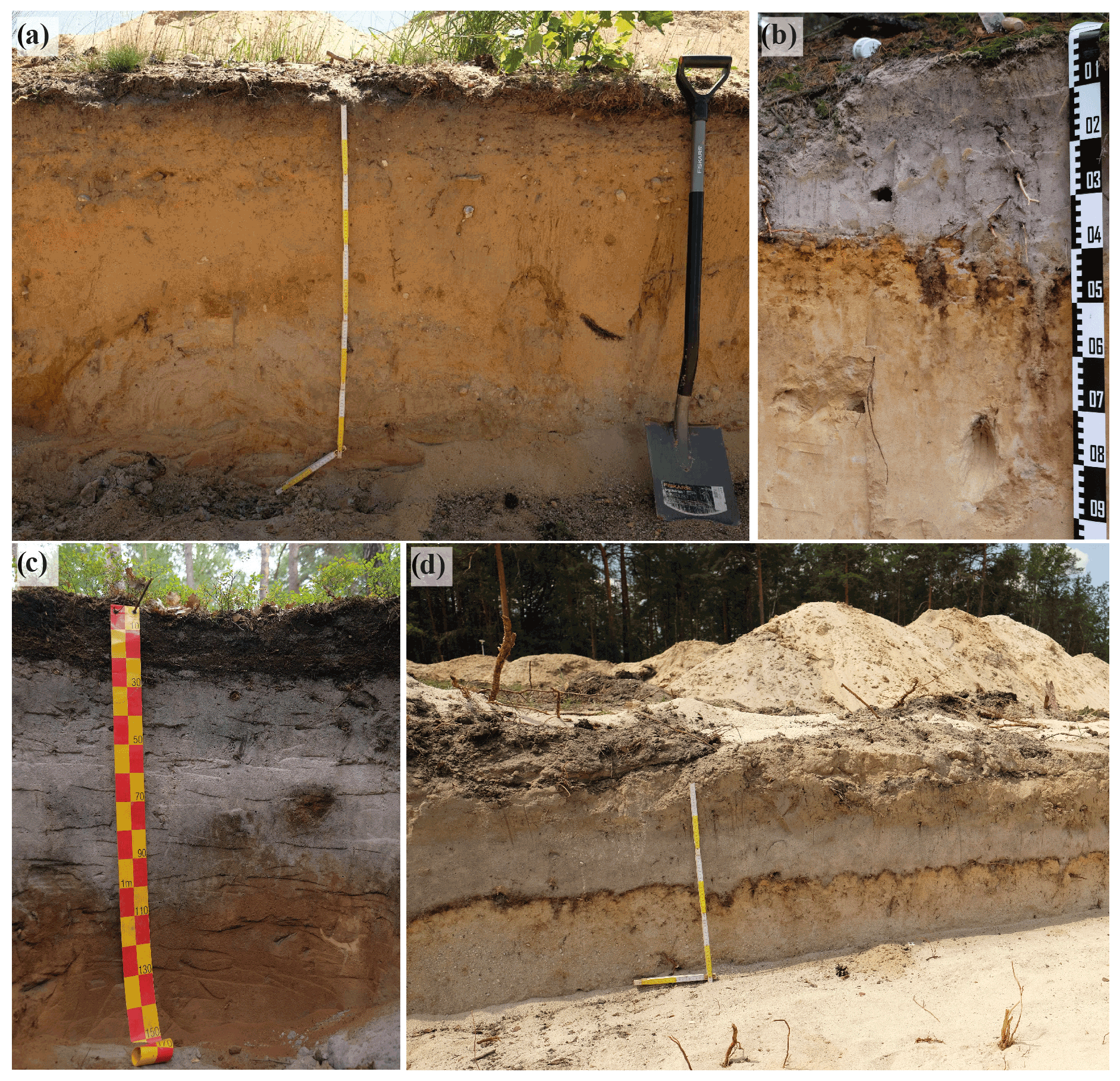
Figure 4(a) Brunic Arenosol; (b) Rustic Ortsteinic Podzol; (c) Carbic Ortsteinic Podzol; (d) young eolian deposits burying a weakly developed Podzol.
Not only in the coversands but also in the glaciofluvial deposits, brunification is prevailing. Due to the high quartz contents of the sandy substrate and the dry and continental climate, the brunificated subsoils have a brown–pale-brown color and are less pronounced than on sites with loamier parent material. Especially on dunes Eisenpodsole are developed (Rustic Ortsteinic Podzol (Arenic) according to World Reference Base for Soil Resources) (Hirsch et al., 2017a), showing the following typical horizon sequence: Ah, Ae, Bsm, Bs and Cv (soil horizons according to Ad-hoc-AG Boden, 2005). Humuspodsole (Carbic Ortsteinic Podzol (Arenic)) are often found in areas where groundwater is or was close to the surface. In contrast to the iron-dominated Eisenpodsol, the total iron contents (Fet) of the Humuspodsol is very low, varying around approximately 300 mg kg−1 in the illuvial horizons. Especially the illuvial horizons of the Eisenpodsol and the Humuspodsol can exhibit very strong cementation even limiting the rooting zone. The formation of cemented horizons in Podzols is not restricted to the illuviation of iron chelates as in Bms or Bhms horizons, but cemented horizons can also form in the absence of iron chelates as in Bmh horizons.
1.2 Carp farming in the Peitz lake area – site 2
Carp farming in Peitz has a 450-year-long tradition. The beginnings reach back to the 16th century. Prior to the construction of the fortress Peitz starting in the year 1559, the area south of the city was comprehensively restructured. In this process, the artificial canal Hammerstrom was built to provide the Peitz ironworks with energy and to drive water wheels. Near Peitz, dams were built on both sides of the trench in order to flood the area and thus to make the area impassable. These lakes were already planned as fishing waters. In the official book Peitzer Amtsbuch of 1554, the Peitz ironworks and lakes are described as fully functional. In the late 1560s, the lakes were expanded and thus contributed to the fortification of the terrain. Fishery, mainly carp farming, was an important source of income for the administrative district Neumark (Müller, 2013).
1.3 Historical iron production in Peitz – site 2: Peitz ironworks
The Peitz ironworks (1544–1856) operated for more than 300 years. The changing history of the ironworks is described in detail by Müller (2014, 2017). Initially, the ironworks produced munition for the fortress Peitz and the Prussian military. Later on, also cast goods and forged parts were produced for civil use (Hettchen et al., 2014). Until the end of the 17th century, it had been the only ironworks in the Mark Brandenburg. According to Müller (2017), the operation of the Peitz ironworks can be considered an example of a typical Prussian facility. One reason for the founding of the Peitz ironworks was the wealth of commodities in the surroundings and their valorization. The availability of large woodlands and bog iron ore deposits in the direct vicinity were certainly decisive criterions.
The work activities were concerned by contemporary political circumstances, e.g., the Thirty Years' War (1618–1648) and Seven Years' War (1756–1763). Further, the productivity of the ironwork was negatively affected by structural defects, the silting up of the man-made watercourse Hammergraben, human resources, and particularly unpredictable environmental factors like weather conditions (e.g., frost, ice) or water shortage. Thus, adverse events caused several downtimes resulting in varied numbers of operational weeks from year to year, and correspondingly, the raw materials consumption varied, too. Although the ironworks operated over 3 centuries more or less successfully, wood exploitation was certainly an important factor. The closure of the ironworks in 1858 resulted in a loss of significance for charcoal production in the region. This coincided with the increasing use of lignite and a general loss of importance of wood charcoal.
1.4 Historical charcoal production in Brandenburg – site 3: Waldschule Kleinsee
The starting point for the mapping of relict charcoal hearths (RCHs) was comprehensive archeological excavations in the active lignite mining area Jänschwalde during the 1990s (Fig. 5). Based on the archeological groundwork and the increasing availability of high-resolution lidar data, remote sensing of RCHs based on digital elevation models (DEMs) was started in 2010 (Rösler et al., 2012). Initially, the study area was limited to the territory of the lignite mine Jänschwalde. Over time and with improved remote sensing methods, the mapping area was extended beyond the limits of the former royal Tauer forest to eventually include the whole state of Brandenburg. In the 32 km2 area of the Jänschwalde mine forefield, about 1400 RCHs had been mapped. Extending the study area to the 109 km2 area of the royal Tauer forest resulted in a dataset of almost 6000 RCHs (Raab et al., 2019), and finally a total of 47 000 sites were mapped for 10 300 km2 of forest area in Brandenburg (Schneider et al., 2020). According to our assessments of mapping quality in several ground-truthing studies (Bonhage et al., 2020; Raab et al., 2019), only about 50 % of the RCHs can be captured using the available DEMs with 1 m spatial resolution.
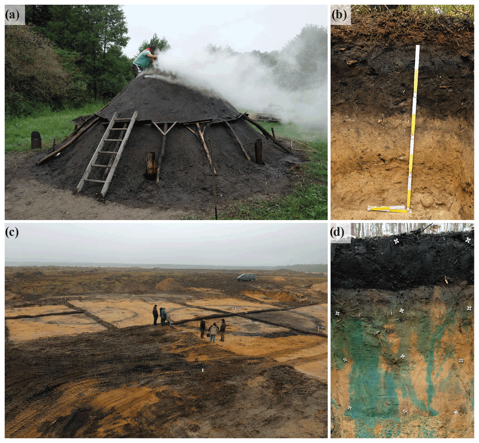
Figure 5(a) Newly constructed charcoal hearth; (b) soil profile of an RCH; (c) archeological excavations of two RCHs in Jänschwalde; (d) dye tracer experiment on an RCH site.
RCHs were found in almost all of the large forest areas in Brandenburg, but their spatial density varied across a wide range (from only a few sites within several square kilometers of the forest to several hundreds of sites per square kilometer). Considerably high RCH densities were found not only in vicinity of the Peitz ironworks (i.e., in the Tauer forest) but also in forests close to other important historic industry sites (e.g., the accumulation of metalworks in Eberswalde and the glassworks in the northern parts of Brandenburg). Nevertheless, the charcoal production field in the Tauer forest is remarkable within Brandenburg because RCHs in the area do not only occur in very high spatial density but also have considerably large diameters of up to 30 m. Similarly, large RCHs were only found in the forest areas south of Eberswalde and, for fewer sites, south of Forst in southeastern Brandenburg. Other areas with very high RCH densities, e.g., in the northernmost part of Brandenburg, are dominated by smaller sites with diameters around 10 m. Very high RCH densities are not only limited to forest areas close to historic industrial sites but also occur in more remote areas, for example, in forest areas north of Berlin and along the Berlin ice-marginal valley between Berlin and Frankfurt (Oder). With only a few exceptions, RCHs in Brandenburg are shaped as slightly elevated platforms with a surrounding ditch, which is the characteristic morphometry of sites on flat landscapes (Raab et al., 2015). For small sites, surrounding ditches are often not observable in DEMs and field surveys. Some larger sites have several pits located concentrically around the platform instead of a continuous ditch, which was similarly described for sites in southern Poland (Rutkiewicz et al., 2019). RCHs shaped as leveled platforms on slopes, an RCH form typically found in low mountain ranges (e.g., Raab et al., 2017; Swieder, 2019), were mapped in only a few individual cases. RCHs are predominantly located in forest areas with sandy parent material, while only a few RCHs occur on silty and clayey substrate and in peat areas within forests. Historical instructions for charcoal production support the interpretation of a preference for hearth construction on sandy soils (von Berg, 1860; Klein, 1836; Krünitz, 1773–1858).
Among other forest areas, those with poorer soil quality (Podzols and Arenosols) clearly show higher RCH densities, similar to observations in Poland (Rutkiewicz et al., 2019). The match between RCH concentration and low-quality soils in Brandenburg might be related to the specific location and spatiotemporal contingency of forest areas in relation to soil properties. In fact, most of the large, historically old (i.e., continuously forested) state forest areas in the region are located in areas with poorer soils (Wulf, 2004). Forests with decent soil quality, for example, Retisols and Luvisols, are often fragmented and distributed over areas dominated by agricultural land use.
The site density in the Tauer forest reaches up to 440 km−2. The site diameters do not show a random spatial distribution pattern but are clustered in hot and cold spots (clusters of large and small sizes). The largest RCH clusters are located north of the village Tauer, east and west of the lake Kleinsee. West of the lake is a cold spot of RCHs consisting of 834 mainly smaller sites. East of the lake is a hot spot, with considerably larger sites but smaller spatial density (Raab et al., 2019).
1.5 Soils on RCHs
The RCH platforms in the Tauer forest show a similar stratigraphy of buried horizons that are overlain by distinct layers of technogenic substrate remaining from charcoal hearth operation (Fig. 5). These remains of the charcoal hearths are dark-gray–black, loose sediment layers rich in charcoal fragments. The thickness of the RCH substrate varies between 20 and 30 cm.
The topsoil horizons buried below the RCH layers (Auh horizons) are often separated by distinct and even boundaries. Sometimes, their topmost centimeters have a slightly more reddish color resulting from thermal alteration of iron (hydr)oxides in some parts of the profiles and thus the appearance of hematite (Hirsch et al., 2017b). The thickness of the buried Ah horizons is often similar to the recent Ah horizons outside of the RCHs. The soil profiles in the remnants of V- to U-shaped ditches surrounding the hearth platforms show infillings with RCH substrate, reaching a depth of approximately 50 cm. The soils of the RCH platforms and ditches are classified as Spolic Technosol over Brunic Arenosol.
According to the German Guidelines for Soil Mapping, the RCHs are classified as Regosol above Braunerde (jAh, jilC, IIfAh, IIBv). However, the anthropogenic origins and the inherited and new chemical and physical characteristics of these soil sediments (jilC) are ignored in this classification. Therefore, adapting the M horizon of the German Guidelines for Soil Mapping, allowing for a jM horizon, is suggested. The implementation of a jM horizon would consider the anthropogenic raised charcoal content and indicate the anthropogenic nature (non-erosive translocated soil substrate) of this sediment. Thus, the soils within the RCHs would be classified as a kolluviale Braunerde because the jM horizon is <40 cm thick. Details on RCH soil taxonomy and further data on RCH soil horizons have been compiled by Hirsch et al. (2017b).
Regarding physical properties of RCH soils, Schneider et al. (2018, 2019a, b, 2020) have recently presented findings from long-term monitoring and further laboratory studies. This research affirms that the technogenic substrate of the RCH is very heterogeneous and contains coarse charcoal fragments of up to 30 wt %. Within the technogenic substrate layers on RCH platforms, the content of coarse charcoal fragments often increases with depth, while ditch fillings often show several layers of sediment with different charcoal fragment contents. Higher root densities were observed in the RCH substrate layers compared to the reference soil outside of the hearths, and a clear preference of root growth in the charcoal-rich substrate, compared with adjacent C horizon material, was observed in the ditch profiles.
Saturated hydraulic conductivity is extremely high for sampled RCHs and reference forest soils because of the sandy parent material. Nevertheless, lower values are observed for the Ah horizons of the undisturbed forest soils, while hydraulic conductivity is clearly higher and more heterogeneous in the RCH substrate and in the RCH-buried Ah horizons. The variability in the hydraulic conductivity data is particularly high in the heterogeneous substrate filling the RCH ditches.
The laboratory data furthermore show a low bulk density and high total porosity for the RCH substrates compared to the soils outside of the RCHs. The bulk densities are significantly lower in the RCH substrate layer and slightly higher in the RCH-buried Ah horizon than in the reference Ah horizons. The pore size distribution, as determined from desaturation water contents, suggests that the higher total porosity of the RCH substrate on the platform and in the ditch profiles is mainly related to higher volumes of coarse and fine pores, while the volume of medium pores in RCH substrates is similar or even lower than in the A horizons of reference forest soils. The high porosity of the RCH substrates is therefore not associated with higher contents of plant-available water per unit volume of soil. Nevertheless, more plant-available water can be stored in the root zone of RCH soils, compared with that of unaffected forest soils, because of the high thickness of the RCH layers and buried A horizons.
Infiltration experiments with a dye tracer (Schneider et al., 2018) showed that water infiltration through RCH substrate layers is limited to very few flow paths under dry antecedent soil conditions, related to the persistent hydrophobicity and heterogeneous structure of the substrates. This observation implies that only small parts of the substrate receive water during infiltration events and therefore that actual plant-available water under field conditions might be considerably lower than indicated by laboratory measurements. In contrast, infiltration experiments for wet antecedent conditions showed that large parts of the RCH substrate layer were almost uniformly wetted during infiltration, and no hydrophobicity was observed in the RCH substrate.
Soil moisture monitoring for two sites in the Tauer forest accordingly showed higher water contents in RCH soils under relatively wet conditions and lower water contents under dry conditions, as well as a more rapid decrease in water contents during drying periods. The results therefore affirm that the legacies of charcoal production increase spatial and temporal variations in soil moisture, which in turn can cause increased variability in ecological site conditions in charcoal production areas.
A potential feedback between soils and vegetation was recently studied by Buras et al. (2020). A dendroecological study with a classic control-treatment design to compare Scots pine growing on RCHs with unmodified soils revealed significantly lower aboveground wood production but systematically higher wood elemental concentrations in RCH trees compared to control trees. Tree height and diameter at breast height were significantly higher for control trees compared to trees growing outside of the RCHs. Tree age as derived from tree ring counts indicated that control and treatment trees originate from the same age cohort. All trees responded negatively to summer temperatures in the year prior to ring formation as well as in the year of growth and positively to summer water availability, indicating drought stress during peak season. XRF (X-ray fluorescence) measurements of tree cores showed that wood chemical properties (Ca, K, Fe and Mn) were consistently different for trees growing on the RCH than the trees outside of the RCHs. These results may indicate a higher investment of Scots pine in belowground tissue to compensate for a lower plant-water availability on relict charcoal hearths.
The charcoal-burning trail Köhlerpfad Waldschule Kleinsee is the result of the project “Erfassung und Bewertung von vorindustriellen Meilerstandorten in Brandenburg – Ein Beitrag zur Bewahrung, Sicherung und nachhaltigen Nutzung einer historischen Kulturlandschaft” funded by the German Federal Environmental Foundation (Deutsche Bundesstiftung Umwelt, DBU). The project is carried out in cooperation with the Brandenburg University of Technology (BTU) Cottbus-Senftenberg, Brandenburgisches Landesamt für Denkmalpflege und Archäologisches Landesmuseum (BLDAM) and Landesbetrieb Forst Brandenburg (LFB).
By means of four stations, the charcoal-burning trail provides information on charcoal burning in general, historical charcoal production in the Tauer forest, relict charcoal hearths as legacy of historical charcoal burning and current research. The trail aims to reach a wide audience including kindergarten kids, school-aged students, university students, researchers and tourists. Since the expected majority of visitors are 6- to 19-year-old school-aged students, outdoor education plays an important role. Among other things, a charcoal-burning site, including a charcoal hearth and a charcoal burner's hut, have been built. The trail is supported by the local Kienstubbenverein Groß Lindow and the Mosaik-Grundschule Peitz.
Ridge-and-furrow systems are a widespread legacy from medieval agriculture, but their usage, size and shape in Europe can vary (Ewald, 1969; Beyaert, 2006; Alcántara et al., 2017). Ridge-and-furrow systems consist of parallel ridges separated by shallow furrows. In northeastern Germany, the ridges are several hundred meters long, but the widths of the ridges of 13.5, 18 or 22.5 m are often a multiple of 4.5 m (4.5 m ≈1 perch; Bönisch, 2001). The usage of moldboard plows together with the organization of the farmland as strip fields caused the formation of ridge-and-furrow systems (Kittler, 1963; Bönisch, 2001). The ridge-and-furrow system was established in Lusatia in the 12th–13th century before hook or scratch plows were common, and the farmland was arranged in blocks (Bönisch, 2001).
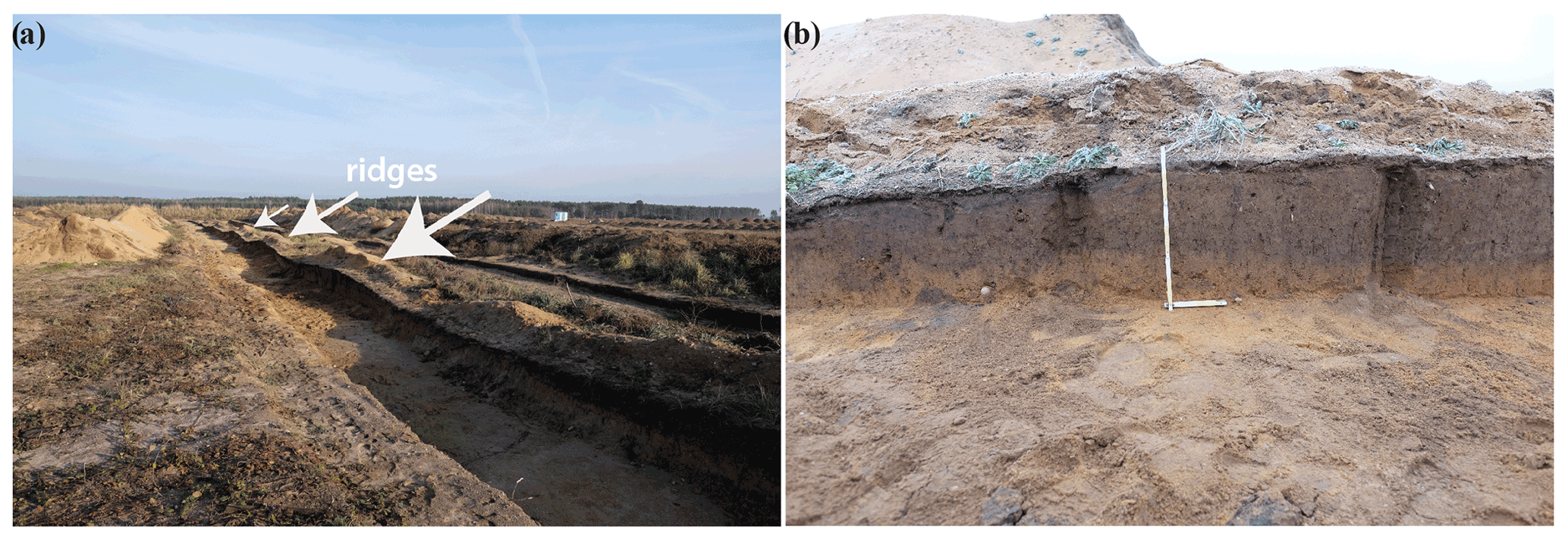
At Grießen (Fig. 6), extensive ridge-and-furrow systems are documented on a historic map (Evert, 1774). Soil mapping shows that topsoils are thicker on the ridges than in the furrows. But soil laboratory analysis shows that the dark-colored topsoils in the furrows contain more soil organic matter (SOM) than the greyish topsoils on the ridges. Due to the higher SOM contents in the furrows, also the bulk density is lower in the topsoil of the furrows than on the ridges. Also, the topsoil in the furrows has a remarkable higher total pore volume. Hence, the effective field capacity is lower in the topsoil of the ridges than in the furrows. Overall, the potential rooting zone is thicker on the ridges than in the furrows, but at least due to the SOM enrichment in the last decades the furrows provide better conditions for plant growth by higher SOM contents and a higher effective field capacity. The pedological findings suggest that the construction of the ridge-and-furrow systems was aimed at improving plant growth on the strip-like ridges by building a surface about 40 cm thick and several meters wide for farming. This is underpinned by the archeological findings; at Grießen indications for shoveling are often found in the furrows. Hence, the buildup of the ridge-and-furrow system is associated with piling up substrate to parallel ridges by shoveling (Bönisch, 2013). Also, the higher concentration of pre-medieval artifacts that were found during archeological excavations in the substrate of the ridges underpins the relocation of substrate from the furrows to the ridges (Schneider, 2016). Hence, the furrows not only provided the substrate for the buildup of the ridges but also served as property lines between neighboring ridges. The historic map of Grießen from 1774 indicates that each farmer owned only one strip; therefore the furrow between two ridges served as the property line. This is also underpinned by placed boulders of up to 40 cm that are often situated in the center of the furrows and are interpreted as landmarks.
Despite recent decisions to reduce carbon emissions, power generation from lignite is still a significant economic factor in Germany. Here, the Rhenish and the Lusatian areas are the most important regions for lignite mining. Near Cottbus (Brandenburg), lignite has been mined for decades in the open-cast mines Cottbus-Nord (discontinued in 2015, Fig. 7) and Jänschwalde (still active).
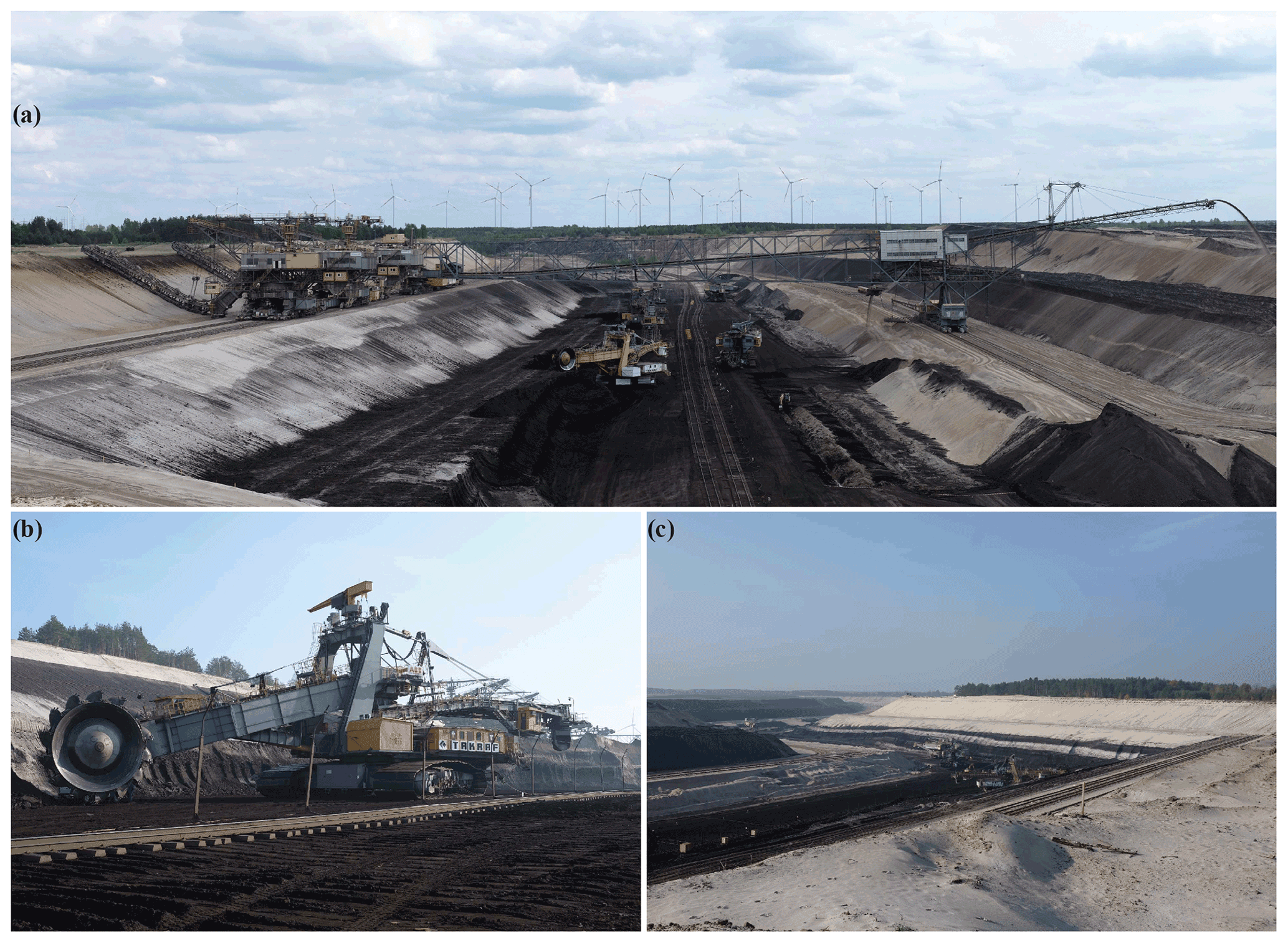
In the open-cast mine Jänschwalde, the lignite is part of the 210 m deep sediment complex from the Cenozoic (Kühner, 2013). Several lignite beds developed due to marine progressions and regressions mainly during the Miocene. In the Jänschwalde mine, the lignite lies in about 50 m depth below the ground surface and is buried by several (deca)meters of glacial and fluvioglacial sediments from the Saalian and Weichselian glaciations. Today, the lignite mine Jänschwalde is operated by the Lausitz Energie Bergbau AG (LEAG). The mining started in 1971 and is planned to end in 2023. The lignite is mined in an open-cast mine with a strip mine approach using a stacker, a conveyer bridge and bucket chain excavators to remove the overburden. Bucket wheel excavators are used to gain the lignite, and the lignite is transported by conveyor belts to the power plant of Jänschwalde about 10 km away.
The formation of hematite in soils (rubification) is a characteristic feature in Mediterranean and tropical environments (Pal et al., 2014; Yaalon, 1997). However, rubified soils have also been reported to occur on late Quaternary sediments within the temperate zone in central Europe (Schwertmann et al., 1982; Jankowski, 2013). The local occurrence of red subsoils on the Late Pleistocene sandy deposits of the NEL invites investigation into the formation and paleoenvironmental significance of these soils (Fig. 8). According to the WRB, these soils are classified as Rhodic Brunic Arenosols or Chromic Brunic Arenosols. In contrast, in the German Guidelines for Soil Mapping these soils are still not considered because of their unclear origins.
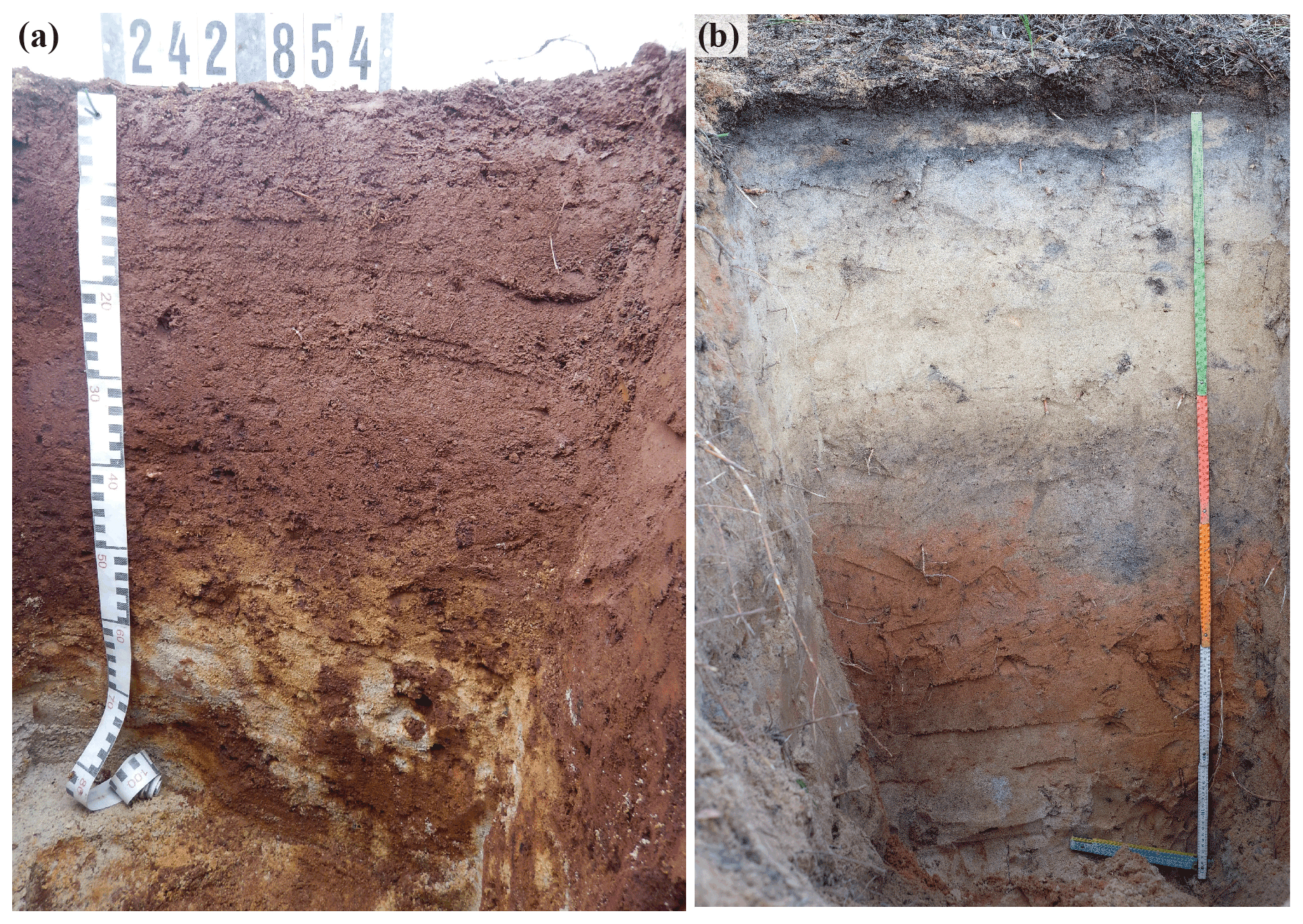
At this stop, we present our findings on rubified soils from recent research (for details see Hirsch et al., 2019). In general, we aim to examine and characterize the genesis of the Fuchserden in northeastern Germany by (1) analyzing their soil geography and (2) analyzing mineralogical and pedochemical compositions. We also (3) decipher the genetic pathway of these soils and (4) examine their potential genetic relationships with neighboring soils and with soils having similar origins. The analytical approach used here differentiates pedogenic iron (hydr)oxides using a combination of Fourier transform infrared–multiple internal reflection (FTIR-MIR) spectroscopy and sequential sample heating. Together with a comparison of synthetic iron (hydr)oxides, the results of this analytical approach demonstrate that the mineralogy of these Rhodic Brunic Arenosols and Chromic Brunic Arenosols are characterized mainly by hematite; some goethite and minor amounts of maghemite are also present. The results confirm recent findings from Jankowski (2013) that rubification is not primarily a relict process in central European soils, consequently. The high total iron contents in the rubified soils suggest strongly that the iron is allochthonous in origin, emphasizing the importance of lateral inputs of iron compounds in the genesis of these soils. This finding is highly consistent with the “translocation catena” concept (Sommer and Schlichting, 1997); i.e., the Rhodic Brunic Arenosols and Chromic Brunic Arenosols studied here were most likely formed by inputs of allochthonous compounds. The rubified soils examined in this study share some genetic features with other central Europe soils described, such as the Lockerbraunerden or the Ockererden. Further research should focus on these commonalities and compare the genetic pathways of such soils to support the argument that these soils should be considered in a separate soil class in the German Guidelines for Soil Mapping.
Data are available through cited publications of the authors in the reference list.
FH drafted the manuscript. TR, AR, AS and ABo contributed text to Sects. 1 and 2. MS wrote the main parts of Sect. 3. ABa made substantial contributions to the text in Sect. 5. All authors revised the final version of the paper.
The contact author has declared that none of the authors has any competing interests.
Publisher’s note: Copernicus Publications remains neutral with regard to jurisdictional claims in published maps and institutional affiliations.
Ad-hoc-AG Boden: Bodenkundliche Kartieranleitung, 5th edn., Bundesanstalt für Geowissenschaften und Rohstoffe, Hannover, 438 pp., ISBN 13: 9783510959204, 2005.
Alcántara, V., Don, A., Well, R., and Nieder, R.: Legacy of medieval ridge and furrow cultivation on soil organic carbon distribution and stocks in forests, Catena, 154, 85–94, https://doi.org/10.1016/j.catena.2017.02.013, 2017.
Bauriegel, A., Kühn, D., Schmidt, R., Hering, J., and Hannemann, J.: Bodenübersichtskarte 1:200.000 Frankfurt (Oder), Blatt 3950, Bundesanstalt für Geowissenschaften und Rohstoffe (BGR), Hannover, 2015a.
Bauriegel, A., Pickert, E., Kühn, D., Krug, D., Eberhardt, E., and Stegger, U.: Bodenübersichtskarte 1:200.000 Cottbus CC 4750, BGR, Hannover, 2015b.
Beyaert, M.: La Belgique en cartes: l'évolution du paysage à travers trois siècles de cartographie, Ed. Lannoo, ISBN13: 9789020968316, 2006.
Bonhage, A., Hirsch, F., Schneider, A., Raab, A., Raab, T., and Donovan, S.: Long term anthropogenic enrichment of soil organic matter stocks in forest soils – Detecting a legacy of historical charcoal production, Forest Ecol. Manag., 459, 117814, https://doi.org/10.1016/j.foreco.2019.117814, 2020.
Bönisch, E.: Forschungspotenzial der Braunkohlenarchäologie zu Besiedelung, Landnutzung, Landschaftsentwicklung und Klimawandel, in: Landschaftswandel – Landscape Change, edited by: Raab, T., Raab, A., Gerwin, W., and Schopper, F., GeoRS, 1, 25–68, 2013.
Bönisch, F.: Wölbäcker als Kennzeichen früherer Gewannfluren, in: Ausgrabungen im Niederlausitzer Braunkohlenrevier 2000, edited by: Kunow, J., Brandenburgisches Landesamt für Denkmalpflege und Archäologisches Landesmuseum, Calau, 203–212, ISBN: 3910011233, 2001.
Buras, A., Hirsch, F., Schneider, A., Scharnweber, T., van der Maaten, E., Cruz-García, R., Raab, T., and Wilmking, M.: Reduced above-ground growth and wood density but increased wood chemical concentrations of Scots pine on relict charcoal hearths, Sci. Total Environ., 717, 137189, https://doi.org/10.1016/j.scitotenv.2020.137189, 2020.
Evert, L. T.: Charte von Grissen, Geheimes Staatsarchiv Preußischer Kulturbesitz Berlin, Plankammer der Reg. Frankfurt (O.), B 352, 1774.
Ewald, K. C.: Agrarmorphologische Untersuchungen im Sundgau (Oberelsass) unter besonderer Berücksichtigung der Wölbäcker, Philosophisch-Naturwissenschaftliche Fakultät Universität Basel, Liestal, 178 pp., 1969.
Gerwin, W., Raab, T., Bauriegel, A., and Nicolay, A.: Junge Böden in der Niederlausitz, Brandenburgische Geowissenschaftliche Beiträge, 22, 135–146, 2015.
Hardt, J.: Weichselian phases and ice dynamics of the Scandinavian Ice Sheet in northeast Germany: a reassessment based on geochronological and geomorphological investigations in Brandenburg, E&G Quaternary Sci. J., 66, 101–102, https://doi.org/10.5194/egqsj-66-101-2017, 2017.
Hettchen, S., Pinkepank, H., Scharnholz, L. I., and Müller, T. S.: Die Spur der Industrie von Lauchhammer bis Nowa Sól, in: Adelslandschaft, Industrielandschaft, Zukunftslandschaft. Deutsch-polnische Touren in Geschichte und Gegenwart der Niederlausitz und südlichen Lubuskie, edited by: Bayerl, G., 2014.
Hirsch, F., Raab, T., Heller, S., and Bauriegel, A.: Classification of pedogenic cementation in Podzols by pocket penetrometry, J. Plant Nutr. Soil Sci., 180, 430–435, https://doi.org/10.1002/jpln.201600395, 2017a.
Hirsch, F., Raab, T., Ouimet, W., Dethier, D., Schneider, A., and Raab, A.: Soils on Historic Charcoal Hearths: Terminology and Chemical Properties, Soil. Sci. Soc. Am. J., 81, 1427–1435, https://doi.org/10.2136/sssaj2017.02.0067, 2017b.
Hirsch, F., Bonhage, A., Bauriegel, A., Schneider, A., Raab, T., Raab, A., and Gypser, S.: The occurrence, soil parameters and genesis of rubified soils (`Fuchserden') of northeastern Germany, Catena, 175, 77–92, https://doi.org/10.1016/j.catena.2018.11.039, 2019.
Jankowski, M.: Gleby ochrowe. Pozycja w krajobrazie, właściwości, geneza i miejsce w systematyce, Wydawnictwo Naukowe Uniwersytetu Mikołaja Kopernika, Toruń, ISBN: 978-83-231-3033-8, 2013.
Kasse, C.: Sandy aeolian deposits and environments and their relation to climate during the Last Glacial Maximum and Lateglacial in northwest and central Europe, Prog. Physical Geogr., 26, 507–532, https://doi.org/10.1191/0309133302pp350ra 2002.
Kittler, G. A.: Das Problem der Hochäcker, Zeitschrift für Agrargeschichte und Agrarsoziologie, 11, 141–159, 1963.
Klein, F.: Ueber Verkohlung des Holzes in stehenden Meilern, Hennings und Hopf, Gotha, 1836.
Krünitz, J.: Oekonomische Encyklopädie oder allgemeines System der Staats-, Stadt-, Haus- und Landwirthschaft in alphabetischer Ordnung, http://www.kruenitz1.uni-trier.de/ (last access: 15 August 2022), 1773–1858.
Kuenen, H. and Perdok, W. G.: Experimental Abrasion 5. Frosting and Defrosting of Quartz Grains, J. Geol., 70, 648–658, https://doi.org/10.1086/626864, 1962.
Kuenen, P. H.: Experimental Abrasion 4: Eolian Action, J. Geol., 68, 427–449, https://doi.org/10.1086/626675, 1960.
Kühn, D., Bauriegel, A., Müller, H., and Rosskopf, N.: Characterisation of soils in Brandenburg concerning distribution, properties and capability including physical and chemical analytical data, Brandenburger geowissenschaftliche Beiträge, 22, 5–135, 2015.
Kühn, P., Billwitz, K., Bauriegel, A., Kühn, D., and Eckelmann, W.: Distribution and genesis of Fahlerden (Albeluvisols) in Germany, J. Plant Nutr. Soil Sci., 169, 420–433, https://doi.org/10.1002/jpln.200521963, 2006.
Kühner, R.: Die geologischen Verhältnisse im Bereich des Braunkohlentagebaus Jänschwalde der Vattenfall Europe Mining AG, in: Arbeitskreis Geoarchäologie – Jahrestagung 2013, 2–4 Mai 2013, BTU Cottbus, Tagungsband und Exkursionsführer, edited by: Raab, T., Hirsch, F., Raab, A., Schopper, F., and Freytag, K., GeoRS, 258–64, ISSN: 2196-4122, 2013.
Liedtke, H. and Marcinek, J.: Physische Geographie Deutschlands. Justus Perthes Verlag Gotha, 786 pp., ISBN-13: 978-3623008608, 2002.
Meyer, H.-H.: Steinsohlen – ihre Genese und Altersstellung nach neueren Forschungsbefunden, Eiszeital. Ggw., 36, 61–73, 1986.
Müller, F: Standort 4 – Eisenhüttenwerk Peitz. Die Peitzer Hütte und das Holz. Der Einfluss eines vorindustriellen Eisenproduzenten auf die Kulturlandschaft im Raum Peitz, in: Arbeitskreis Geoarchäologie – Jahrestagung 2013, 2–4 Mai 2013, BTU Cottbus, Tagungsband und Exkursionsführer, edited by: Raab, T., Hirsch, F., Raab, A., Schopper, F., and Freytag, K., GeoRS, 2, 98–102, 2013.
Müller, F.: Erzwungene Nachhaltigkeit? Die Peitzer Amtsheiden unter dem Einfluss des örtlichen Hüttenwerkes, Jahrbuch für Regionalgeschichte, 32, 55–72, 2014.
Müller, F.: Der Wandel der Kulturlandschaft im Raum Peitz infolge des mehrhundertjährigen Betriebes des dortigen Eisenhüttenwerkes (Mitte 16. bis 19. Jahrhundert), GeoRS, 6, 428 pp., https://nbn-resolving.org/urn:nbn:de:kobv:co1-opus4-41443 (last access: 15 August 2022), 2017.
Nicolay, A.: Untersuchungen zur (prä-)historischen Relief-, Boden- und Landschaftsentwicklung im südlichen Brandenburg (Niederlausitz), Brandenburg University of Technology Cottbus, https://opus4.kobv.de/opus4-btu/frontdoor/index/index/docId/4433 (last access: 15 August 2022), 2018.
Pal, D. K., Wani, S. P., Sahrawat, K. L., and Srivastava, P.: Red ferruginous soils of tropical Indian environments: A review of the pedogenic processes and its implications for edaphology, Catena, 121, 260–278, https://doi.org/10.1016/j.catena.2014.05.023, 2014.
Raab, A., Takla, M., Raab, T., Nicolay, A., Schneider, A., Rösler, H., Heußner, K. U., and Bönisch, E.: Pre-industrial charcoal production in Lower Lusatia (Brandenburg, Germany): Detection and evaluation of a large charcoal-burning field by combining archaeological studies, GIS-based analyses of shaded-relief maps and dendrochronological age determination, Quatern. Int., 367, 111–122, https://doi.org/10.1016/j.quaint.2014.09.041, 2015.
Raab, A., Bonhage, A., Schneider, A., Raab, T., Rösler, H., Heußner, K. U., and Hirsch, F.: Spatial distribution of relict charcoal hearths in the former royal forest district Tauer (SE Brandenburg, Germany), Quatern. Int., 511, 153–165, https://doi.org/10.1016/j.quaint.2017.07.022, 2019.
Raab, T., Hirsch, F., Ouimet, W., Johnson, K. M., Dethier, D., and Raab, A.: Architecture of Relict Charcoal Hearths (RCHs) in Northwestern Connecticut, USA, Geoarchaeology, 4, 85–89, https://doi.org/10.1002/gea.21614, 2017.
Rösler, H., Bönisch, E., Schopper, F., Raab, T., and Raab, A.: Pre-industrial charcoal production in southern Brandenburg and its impact on the environment, in: Landscape Archaeology between Art and Science, edited by: Kluiving, S. and Guttmann-Bond, E., Landscape and Heritage Series, Amsterdam University Press, Amsterdam, 167–178, ISBN-13: 978-9089644183, 2012.
Rutkiewicz, P., Malik, I., Wistuba, M., and Osika, A.: High concentration of charcoal hearth remains as legacy of historical ferrous metallurgy in southern Poland, Quatern. Int., 133–143, https://doi.org/10.1016/j.quaint.2019.04.015, 2019.
Schneider, A., Hirsch, F., Raab, A., and Raab, T.: Dye Tracer Visualization of Infiltration Patterns in Soils on Relict Charcoal Hearths, Frontiers in Environmental Science, 6, 143, https://doi.org/10.3389/fenvs.2018.00143, 2018.
Schneider, A., Hirsch, F., Raab, A., and Raab, T.: Temperature Regime of a Charcoal-Enriched Land Use Legacy Soil, Soil. Sci. Soc. Am. J., 83, 565–574, https://doi.org/10.2136/sssaj2018.12.0483, 2019a.
Schneider, A., Nguyen, V. X., Viala, Y., Violo, V., Cornu, J.-Y., Sterckeman, T., and Nguyen, C.: A method to determine the soil-solution distribution coefficients and the concentrations for the free ion and the complexes of trace metals: Application to cadmium, Geoderma, 346, 91–102, https://doi.org/10.1016/j.geoderma.2019.02.001, 2019b.
Schneider, A., Bonhage, A., Raab, A., Hirsch, F., and Raab, T.: Large-scale mapping of anthropogenic relief features – legacies of past forest use in two historical charcoal production areas in Germany, Geoarchaeology, 35, 545–561, https://doi.org/10.1002/gea.21782, 2020.
Schneider, M.: Äcker, Brunnen und Grenzen auf Grießener und Jänschwalder Flur im archäologischen Befund (Ausgrabungen 2013), Arbeitsberichte zur Bodendenkmalpflege in Brandenburg, 20, 131–144, 2016.
Schwertmann, U., Murad, E., and Schulze, D. G.: Is there holocene reddening (hematite formation) in soils of axeric temperate areas?, Geoderma, 27, 209–223, https://doi.org/10.1016/0016-7061(82)90031-3, 1982.
Sommer, M. and Schlichting, E.: Archetypes of catenas in respect to matter – a concept for structuring and grouping catenas, Geoderma, 76, 1–33, https://doi.org/10.1016/S0016-7061(96)00095-X, 1997.
Swieder, A.: Meilerrelikte als Teil der archäologischen Kulturlandschaft im östlichen Harz, in: Erfassung und Bewertung von Meilerstandorten – Workshop 19. Februar 2019, edited by: Raab, T., Raab, A., and Schopper, F., GeoRS, 8, 43–70, https://doi.org/10.26127/BTUOpen-4817, 2019.
von Berg, C. H. E.: Anleitung zum Verkohlen des Holzes: ein Handbuch für Forstmänner, Hüttenbeamte, Technologen und Cameralisten, Zernin, 1860.
Wulf, M.: Plant species richness of afforestations with different former use and habitat continuity, For. Ecol. Manage., 195, 191–204, https://doi.org/10.1016/j.foreco.2004.02.046, 2004.
Yaalon, D. H.: Soils in the Mediterranean region: what makes them different?, Catena, 28, 157–169, https://doi.org/10.1016/S0341-8162(96)00035-5, 1997.
- How to cite
- Abstract
- Introduction
- Charcoal-burning trail
- Ridge-and-furrow systems at Grießen – site 4: historical tillage near Grießen
- Open-cast lignite mine Jänschwalde – site 5: lookout at Grießen
- Late Quaternary rubification in soils – site 6: rubification at Klein Kölzig
- Data availability
- Author contributions
- Competing interests
- Disclaimer
- References