 | 15 Sep 2022
Quaternary geology and landforms around Potsdam by bike
Bernhard Diekmann
Werner Stackebrandt
Roland Weiße
Margot Böse
Udo Rothe
Boris Biskaborn
Achim Brauer
- Article
(21257 KB) - Full-text XML
- BibTeX
- EndNote


Diekmann, B., Stackebrandt, W., Weiße, R., Böse, M., Rothe, U., Biskaborn, B., and Brauer, A.: Quaternary geology and landforms around Potsdam by bike, DEUQUA Spec. Pub., 4, 5–17, https://doi.org/10.5194/deuquasp-4-5-2022, 2022.
The bike excursion around the river Havel waters of Lake Templin and Lake Schwielow follows routes and sites introduced in a set of former field guides, treatises, and maps, dealing with the natural and cultural heritage of Potsdam and its surrounding areas (Kramm, 1989; Weiße, 1995, 2001, 2012a, b; Grunewald and Marcinek, 1995; Rowinsky, 1995; Schroeder, 2001; Böse and Brande, 2002; Hermsdorf, 2005; Lutze, 2014; Stackebrandt and Franke, 2015; Stackebrandt, 2020). Most of the explanatory texts and illustrations have been published in German and are adopted here for the given background information and description of stops. Some of the figures have been modified, as referred to in the captions. In 1990, Potsdam was declared a UNESCO World Heritage Site of parks and palaces along the idyllic lakes of the Havel River, and it is a grand and historical city of culture and science (Horn, 2005; Lange, 2016). The bike tour highlights some aspects of the natural and cultural heritage of the Potsdam area.
The Quaternary geology and landscape of Brandenburg, comprising wide areas of the northern German lowlands, were basically shaped by the last three glacial and interglacial cycles during the Middle and Late Pleistocene (Schroeder et al., 2001; Lippstreu et al., 2015; Böse et al., 2018; Stackebrandt, 2020). Roughly about 95 % of Brandenburg is covered by loose sediments of glacigenic, fluvioglacial, alluvial, limnic, and palustrine origin, reaching thicknesses of more than 500 m in deeply incised troughs of the Elsterian Stage. These deep valleys were generated not solely by exogenic erosion but also by preceding neotectonic movements that prepared troughs for the accommodation of thick preglacial soft sediments, easily eroded by glacial action (Stackebrandt, 2009). The present landscape of Brandenburg from south to north is occupied by morainic belts and meltwater deposits of maximum advancing and decaying ice masses of the Scandinavian Ice Sheet during the Saalian and Weichselian stages, separated by large ice-marginal valleys (Urstromtäler) that drained the proglacial meltwaters from northerly directions as well as the rivers from the south towards the northwest (Fig. 1).
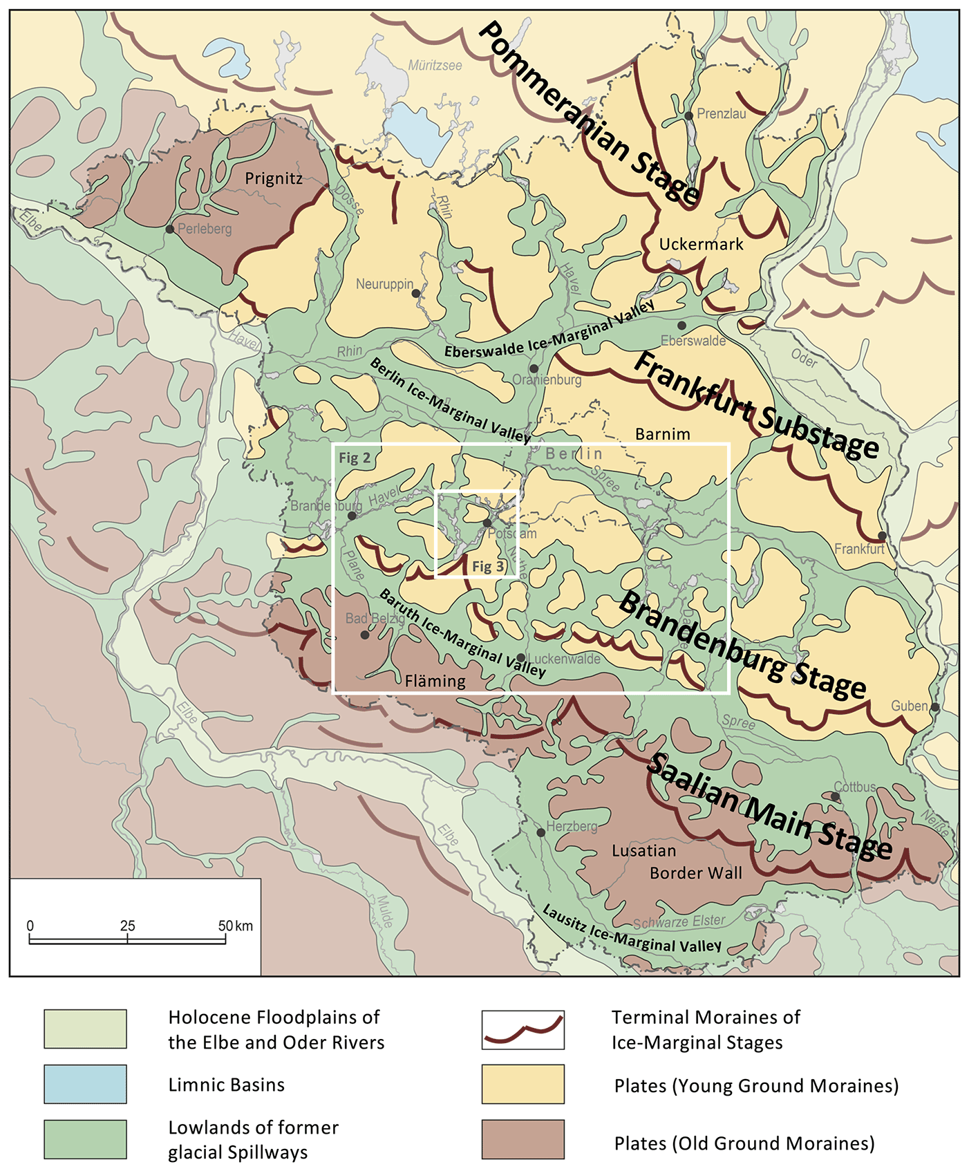
Figure 1Geomorphological units of Brandenburg (modified after Stackebrandt and Franke, 2015; Stackebrandt, 2020). Insets show the positions of the maps in Figs. 2 and 3.
A reliable understanding of the right chronological order of the ice-marginal stages still suffers from contradictory dating results. Traditional approaches invoked morphostratigraphic correlations and the dating of organic matter included in interglacial and interstadial sediments under- and overlying sediments of morainic materials (Cepek, 1965; Lüthgens and Böse, 2012; Lippstreu et al., 2015). With growing progress in exposure dating techniques, such as optical stimulated luminescence (OSL) and surface exposure dating (SED), it became possible to also date glacigenic and glaciofluvial deposits directly related to the timing of ice-sheet dynamics (Brauer et al., 2005; Lüthgens and Böse, 2012; Hardt and Böse, 2016). The latest findings show that ice margins were not a static feature in time, as suggested by morphostratigraphic interpretations, but revealed marked diachronous behaviour both at a regional scale (Böse et al., 2018; Lüthgens et al., 2020) and for the entire Scandinavian Ice Sheet (Hughes et al., 2015).
The hills of the Fläming region together with the Lusatian border wall (Lausitzer Grenzwall), situated about 50 km south of Potsdam, reach the highest elevations in Brandenburg (140 to 200 m a.s.l.) and represent the morainic remnants (Altmoränenlandschaft) of the Warthe Stage (Marine Isotope Stage (MIS) 6) of the Saalian glaciation (Lippstreu et al., 2015; Meschede and Warr, 2019). Although the morainic surface is very smooth, lobes of differing end moraines and block chains appear beneath the periglacially formed ground layer. Exposure dating suggests formation of the Saalian ice margin between 170 and 150 ka (Krbetschek et al., 2008; Rinterknecht et al., 2012). In contrast to younger glacial belts, the Fläming landscape is barren of any lakes but was covered by aeolian sandy loess, creating a NW–SE-striking belt.
The area around Potsdam was basically shaped by glacial advances during the late Weichselian Brandenburg Stage, corresponding to the local Last Glacial Maximum around 24 ka (Böse et al., 2012; Hughes et al., 2015). The latest OSL data from meltwater sediments challenge this dating and provide older ages of between 34.0 and 27.0 ka (Lüthgens et al., 2010a, b, 2020).
The Frankfurt substage ice margin north of Berlin likely is represented by several younger recessional stillstands of the Brandenburg advance (Hardt et al., 2016). The youngest glacial advance in Brandenburg is documented by the Pomeranian ice margin that occupies the northeastern part of Brandenburg. Dating results range between 15 ka (Litt et al., 2007) and 20 ka (Lüthgens et al., 2011; Hardt and Böse, 2016).
Situated between the wide glacial spillways of the Berlin and Baruth ice-marginal valleys, the area around Potsdam lies in the reaches of the Brandenburg ice-marginal stage. The area is characterized by a complex mosaic of morphological plates, morainic ridges, and lowland valleys (Weiße, 1991; Stackebrandt and Manhenke, 2004; Hermsdorf, 2005; Lutze, 2014) (Figs. 2, 3). This morphological configuration is not consistent with a simplified glacial-series concept. Strong overprinting was generated by dead ice, meltwater, and permafrost, creating a kame topography (Weiße, 2012a, b). Likewise, it seems that Late Pleistocene glaciation was routed by the preformed underground structure, created by neotectonics and former glaciations (Stackebrandt, 2009; Lippstreu et al., 2015). In analogy to the southeast orientation of the Nuthe River valley and the southwest elongation of the modern Havel River, two prominent palaeo-depressions cut about 150 m below the surface into Neogene sediments at 120 m below modern sea level. Between the two palaeo-depressions a common Quaternary sequence can be found (Fig. 4). Depositional infills of the depressions comprise sediments of the last 440 kyr, with glacial tills and meltwater sediments of the Elsterian, Saalian, and Weichselian stages, as well as intercalated organic muds and peats of the Holsteinian and Eemian interglacials and of the Holocene. Mainly late Weichselian and Holocene sediments cover the modern landscape around Potsdam. Locally, outcrops of older deposits occur in morphological plates, which often include a core of basal tills of the Saalian glaciation (Fig. 3).
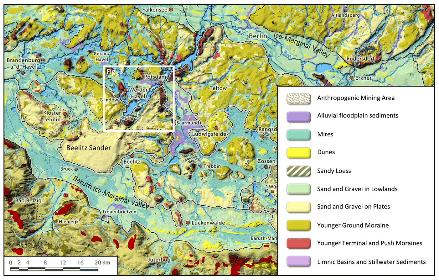
Figure 2Geological map of the wider surrounding of Potsdam (modified from Lutze, 2014). Inset shows position of the map in Fig. 3.
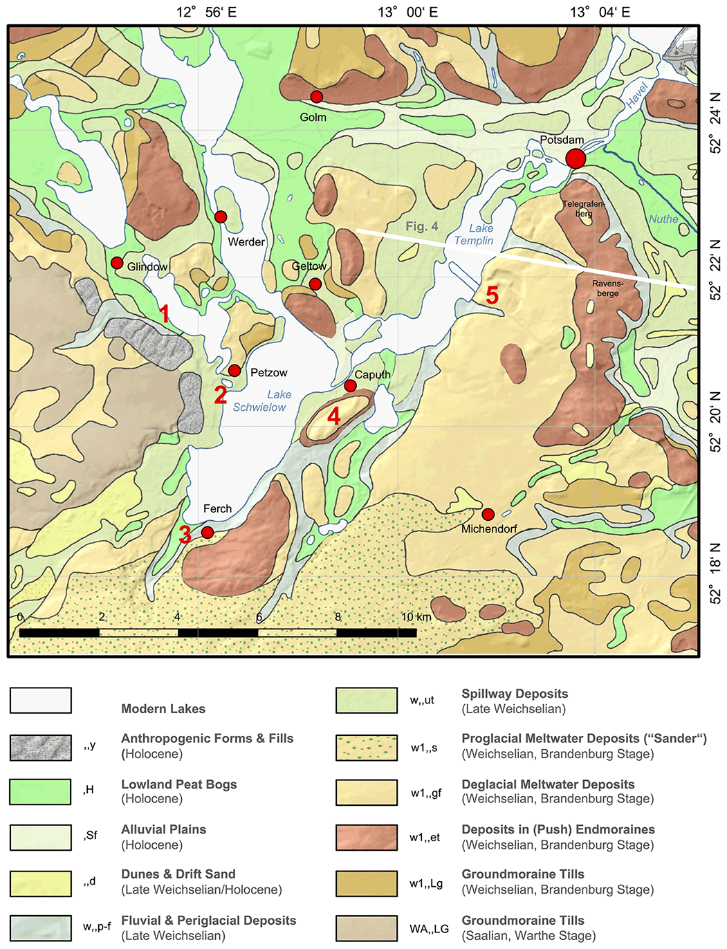
Figure 3Geological map of the area southwest of Potsdam, redrawn from the 1 : 100 000 geological map of Hermsdorf (2005). The map is underlain by relief obtained from a DGM (Digitales Geländemodell, i.e. digital elevation model) of the Brandenburgviewer (LGB, 2020). Red numbers indicate the stops of the field trip. The white line shows the approximate location of the geological profile depicted in Fig. 4.
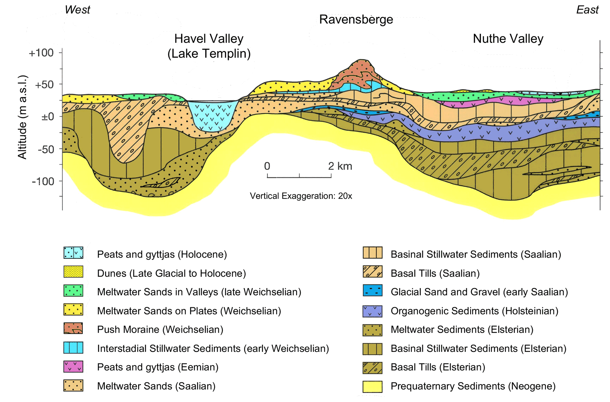
Figure 4Generalized geological profile through the Quaternary sedimentary section of Potsdam (unpublished after Norbert Hermsdorf, Landesamt für Geowissenschaften und Rohstoffe Brandenburg, LGRB). Location of profile is shown in Fig. 3.
During the late Weichselian glacial maximum, the ice sheet reached 125 to 200 m thickness north of Potsdam (Weiße, 2012a). Bulldozing processes by the advancing ice lobes created a set of lateral and terminal push moraines, made up of compressed, imbricated, and folded proglacial sands and older tills. Today, they represent the highest morphological ridges and peaks around Potsdam (80 to 125 m a.s.l.), often fringing the margins of the plates. In places, thin, up to 4 m thick layers of basal till of this advance are preserved as ground moraines on the plates. Glacial advance around Potsdam was driven by two ice lobes. One of those traversed the Nuthe Valley in a westward direction; another one filled the Havel River valley and moved in a southward direction (Weiße, 1991; Hermsdorf, 2005). During its maximum extent, the ice sheet with its different lobes reached nearly the northern slopes of the Fläming Hills south of the Baruth ice-marginal valley and then retreated to the north (north of the then active Baruth ice-marginal valley), where they formed a stagnating ice margin, which nonetheless was not persistent in space and time (Juschus, 2010; Böse et al., 2018). During that time, the ice lobe filling the Havel depression scoured the underground down to 60 m below the present-day surface, by both glacial exaration and strong subglacial meltwater erosion. Sediment-laden meltwater from subglacial tunnels of that lobe fed a huge, 70 km2 proglacial outwash cone (sandur, Sander in German), which passes over at its marginal fringe into the Baruth ice-marginal valley. The so-called “Beelitz Sander” is located about 20 km south of Potsdam (Figs. 2, 5).
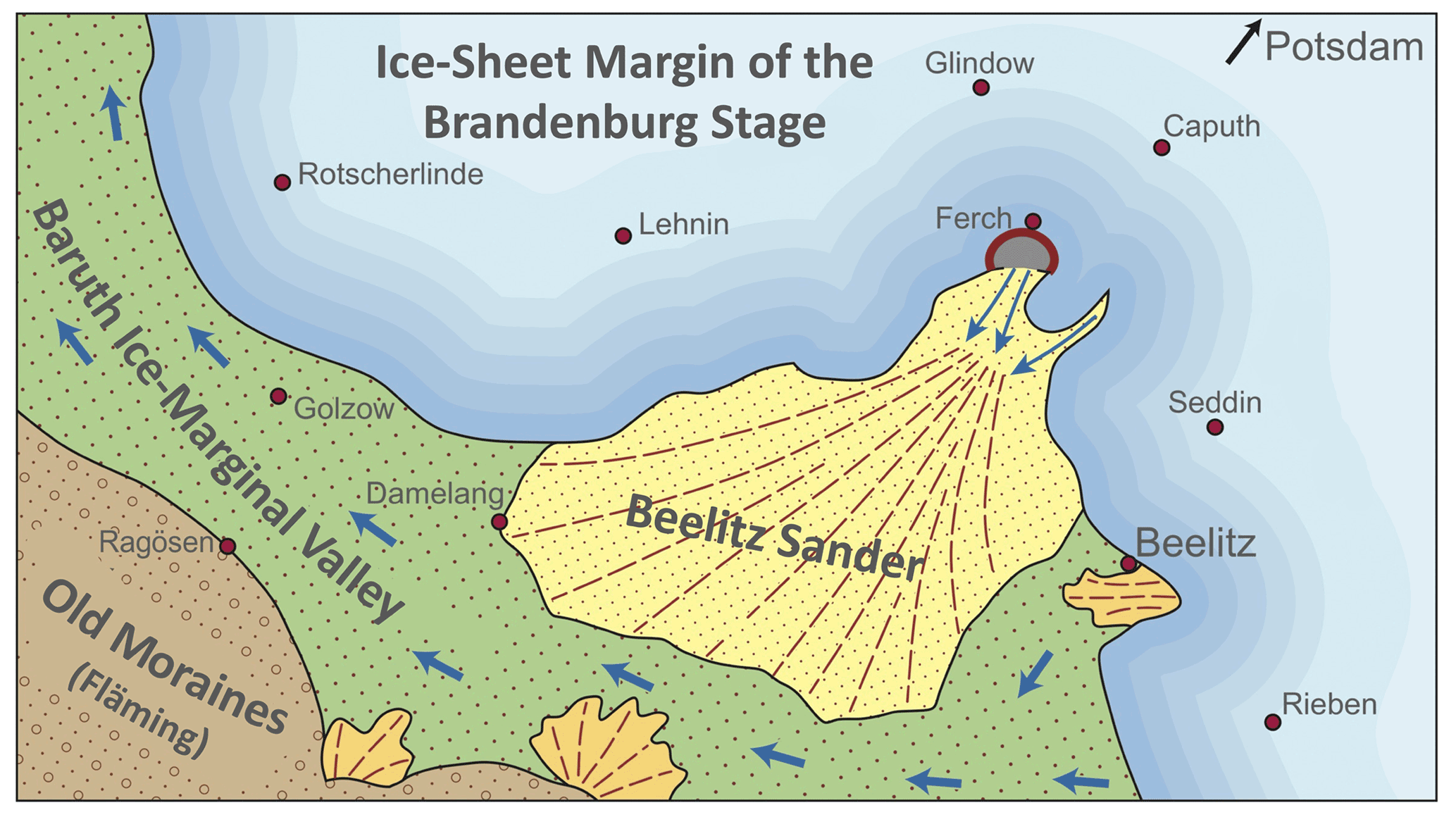
Figure 5The outwash cone of the Beelitz Sander at the Weichselian ice margin south of Potsdam (modified from Stackebrandt, 2020).
During deglaciation, ice-sheet retreat and disintegration led to the isolation of motionless ice fields and blocks in the northern hinterland of the former ice margin (Weiße, 1991, 2012a, b). The collapse of subglacial valleys sealed meltwater channels by dead ice (Juschus, 2010). The glacial sediments carried by meltwaters were deposited on and between the ice remnants. During final deglaciation, they left behind kame hills and kame terraces with ancient ice-contact slopes. Except for a few dead ice relics preserved by overlying sediments, ice decay was likely completed at the latest during Bølling–Allerød warming, roughly between 15.0 and 13.0 ka. This time was characterized by boreal climate conditions and the growth of birch and pine woodlands (Rowinsky, 1995; Wolters, 1999; Brande and Rowinsky, 2017). Glacial decay significantly changed the drainage path of meltwater flow away from the Baruth ice-marginal valley towards the northern hinterland of the former ice margin (Juschus, 2010). With its height of 70–80 m, the Beelitz Sander became a topographical barrier and diverted meltwater discharge to the neighbouring Kanin Valley (Kaniner Tal; 40–60 m a.s.l.) (Böse and Brande, 2002) (Fig. 3).
With ongoing unsealing of the local lowlands, other meltwater routes followed the Nuthe depression to the northwest, the Havel depression to the southwest, and in a westward direction the valleys west of Potsdam (Weiße, 2001, 2012a). During the late glacial Younger Dryas, climate deterioration caused a return to subarctic conditions, dominated by waterproof permafrost ground and periglacial processes (Weiße, 2001). Dry valleys and screes formed along steep slopes, while surficial soils and sediments were affected by cryoturbation and ice-wedge growth. Dryness and a sparse vegetation cover gave rise to aeolian sediment remobilization and the transformation of dune fields (Kaiser et al., 2009). Nevertheless, as a consequence of medieval German settlement and deforestation, a reactivation of sands by aeolian processes caused the formation of dunes on the southern part of the Glindow plate close to Bliesendorf, burying the Holocene brown soil (Brande et al., 1999; Böse et al., 2002).
Today's temperate climate and modern environment developed during the Holocene. The last remains of dead ice finally melted out. Lake basins, modern river courses, floodplains, and wetlands occupied the valleys, while small hollows were filled with ponds and mires (Wolters, 1999; Weiße, 2001; Brande and Rowinsky, 2017). Mixed pine and deciduous forests expanded at the expense of pine woodlands (Wolters, 1999).
Anthropogenic land use in the Late Holocene changed natural landscape, vegetation, and hydrology around Potsdam (Böse et al., 2002; Viehrig, 2002; Rubin et al., 2008; Lutze, 2014). In particular, deforestation, pasture farming, the expansion of hunting grounds, fruit and wine growing, and damming, as well as peat and clay mining, left their tracks in the modern cultural environment.
After the slavonic settlements mainly founded from the 4th to the 8th century, a major rural transformation changed the aspect of the landscape with the German settlement from the 11th century onwards. The plates were widely cleared for agricultural purposes, using new ploughing techniques. The area southwest of Potsdam was predominantly influenced by the foundation of the Lehnin monastery in 1180 and the related villages in the surroundings (Böse et al., 2002). A major transformation in the river system and the adjacent lowlands was induced by the medieval German construction of watermills and consequent damming. The Potsdam area was mainly influenced by the dam built in Brandenburg in 1309, which induced a water-level rise of more than 1 m in the Havel system and a groundwater-level rise in the adjacent flat areas (Kaiser et al., 2017).
From the 17th century the Prussian regency started to design the landscape around Potsdam, characterized by parks and forests for hunting, the intensification of agriculture, development of infrastructure (canals, roads), and the expansion of settlement areas (Viehrig, 2002; Rubin et al., 2008; Lutze, 2014; Lange, 2016). The increasing demand for wood in industry, for building timber, and for firewood in the cities led to an acute shortage of wood in the 18th century. Soils became impoverished in nutrients such that they only allowed for the cultivation of pine trees. Efforts for reforestation increased in the late 19th and early 20th centuries and in particular after World War II, leading to the widespread presence of pine forests in Brandenburg (MLUL, 2015).
Today, a variety of landscapes, geomorphology, soils, and hydrology are reflected in different forms of land use (Brande et al., 1999; Knothe, 1995; Lutze, 2014). Agriculture and fruit growing mainly take place on the plates with their glacial tills and sands that are covered by brown earth and para-brown earth soils with leak waters. The steep terminal moraines, outwash plains, and dune fields are mostly covered by forests; exposed southern slopes are partly covered with vineyards.
The valleys with groundwater fluctuations are used for agriculture or are covered by green land. Parks in and around Potsdam are often located on river terraces with sandy substrate underneath. The Beelitz Sander represents a famous environment for the cultivation of asparagus. The use of raw materials from natural substrates, such as peat, clay, and sand, play a role today and have done in the past.
In addition to raw materials, other resources relate to water management and the utilization of geothermal energy. Infiltration water of the Havel River including especially water from the second groundwater level located beneath an impermeable layer provides a rate of 8000 to 10 000 m3 of potable water per day in each of the five waterworks, sufficient for the whole Potsdam community (180 000 inhabitants). The use of near-surface groundwater is influenced by saltwater brine, which is often bound to Elsterian glacial erosion zones as deep valleys (e.g. Nillert et al., 2008). Thermal influx from depth is already used for numerous geothermal heat pumps installed for the heating of single-family houses. Complex geothermal probe fields are being implemented or planned, which will also meet higher performance requirements.
The bike tour stretches about 30 km around Lake Templin and Lake Schwielow, which are part of the open lake and river system of the Havel River (Fig. 3). It starts in the historical centre of Potsdam and follows in a southward direction the western shore of the Havel River. The side views give insight into the history and cultural development of Potsdam. The skyline opposite the river Havel follows the ridges of the lateral moraines of the Telegrafenberg and Ravensberge. The next stops highlight the glacial and postglacial development of the area and deal with geomorphology, land use, exploitation of raw materials, and cultural history.
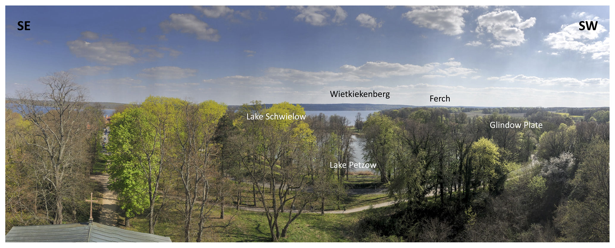
Figure 6Panoramic view from the tower of the village church of Petzow (52∘20.74′ N, 12∘56.52′ E) (photo: Bernhard Diekmann, 2022). The village of Petzow is hidden by trees to the left. The treeless plateau on the right side shows the surface of the Glindow plate to the southwest. The middle part offers an eastward view across the kettle depression of Lake Petzow with Lake Schwielow in the background. The glacial lobe of the Havel River valley terminates in Ferch at the southern end of the Lake Schwielow depression to the right. The hills on the opposite side of Lake Schwielow delineate the ridge of Wietkiekenberg (125 m a.s.l.), a push moraine at the ice-marginal position of the Brandenburg Stage, the highest elevation around the excursion route.
4.1 Stop 1: Petzow
The scenic surroundings of the village of Petzow with its 400 inhabitants, embedded in a hilly kame landscape, highlight the intimate fusion of nature and culture, which is so typical of the wider Potsdam area (Weiße, 1995). First mentioned in 1419, the village with its present Brandenburg brickstone architecture was created during the early 19th century. A neoromantic church, erected by Karl Friedrich Schinkel in 1841, towers the village to the west. To the east, a palace in English Tudor style borders the village close to the shore of Lake Schwielow. The famous royal gardener Peter Joseph Lenné designed the idyllic, 15 ha castle park that surrounds Lake Petzow, a prominent kettle lake filling the depression between Lake Glindow and Lake Schwielow. A view from the tower of the village church offers a view across the adjacent glacigenic landscape (Fig. 6).
4.2 Stop 2: Glindow Alps
The area between Glindow and Petzow delineates the northeastern margin of the Glindow plate, basically a ground moraine of Saalian age, overlain by thin veneers of Weichselian tills and melt-out sands and gravel (Figs. 3, 7). Along the southwestern shore of Lake Glindow, interstadial lacustrine meltwater clays were deposited between tills of the Drenthe and Warthe stages and squeezed by glacial push, leaving behind contorted and imbricated layers of clay deposits (Dienemann, 1928; Weiße, 2012b). The NW–SE-oriented folds and slices are proof of a glacial tectonic compression from the northeast.
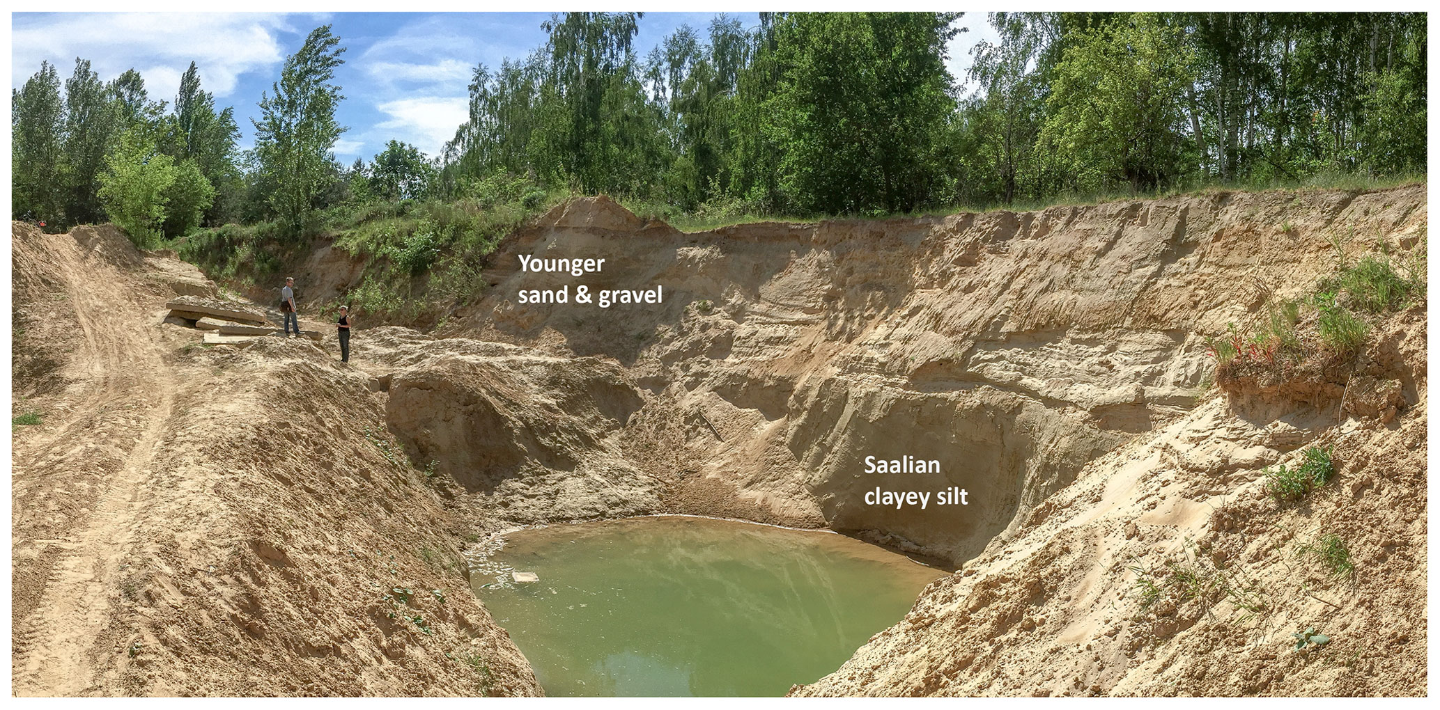
Figure 7Open pit on the northeastern part of the Glindow plate (52∘20.26′ N, 12∘55.69′ E) (photo: Bernhard Diekmann, 2016), used for clay mining. Meanwhile, the exposure has been filled up and is no longer accessible.
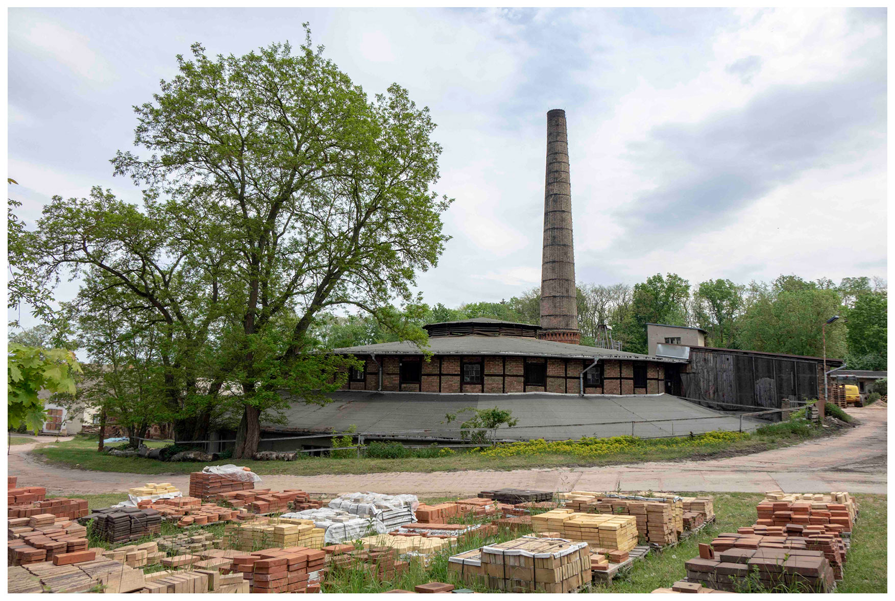
Figure 8Ring furnace of a brick manufactory in the Glindow Alps (52∘21.3′ N, 12∘55.4′ E) (photo: Bernhard Diekmann, 2020, with courtesy of the Brickyard Museum of Glindow).
With the expansion of Potsdam and the neighbouring city of Berlin in the Wilhelminian era of the late 19th to early 20th century, the demand for building materials rose and the brick and tile industry experienced an unprecedented upswing. Around Glindow, glaciolacustrine clays (Bändertone) were exploited as raw materials (Fig. 7) in more than 10 pits that benefited from the water front position of the Havel lakes (Weiße, 1995, 2012b). Today, only one of the brick manufactories is in occasional operation and serves as a mining museum (Fig. 8).
Clay mining proceeded in trenches, after the non-clay substrates had been removed and piled to the side. The exploitation of the raw materials and redeposition of unusable sediments and soils created a human-made terrain of canyons, hills, and hollows, today known as the Glindow Alps. The renaturation of the area led to reforestation, the formation of valuable ponds for aquatic life, and the establishment of dry grasslands, serving as a natural reserve.
4.3 Stop 3: ice-marginal and postglacial landscape of Ferch
The village of Ferch with its population of about 1800 inhabitants is situated at the southernmost tip of Lake Schwielow, roughly 12 km south of Potsdam (Fig. 3). The area lies directly at the former ice front of the Brandenburg Stage (Rowinsky, 1995; Böse et al., 2002; Hermsdorf, 2005; Brande and Rowinsky, 2017). A 20 m high rise to the south of Ferch marks the transition to the outer sandy meltwater cone of the Beelitz Sander (Fig. 5). The sandur was fed through a glacier mouth (Fercher Gletschertor) by meltwaters of a subglacial channel, crossing the village of Ferch from NNE to SSW. Glacial retreat produced a kame landscape with elongated hollows and crests. The inner slope of the Beelitz Sander blocked and diverted the draining meltwater streams to the northwest through the subaerial Kanin Valley, which also hosts dune fields of possibly late glacial age (Fig. 3). The former subglacial channel was filled with 65 m of deglacial clastic sediments, graded into lacustrine and palustrine sediments that underlie the modern wetland of the Ferch valley (Rowinsky, 1995). Within the postglacial sequence a 2 cm layer of the aeolian Laacher See tuff was also found. In analogy, the small basins of the neighbouring kame terrain developed from kettle ponds to mires during the Holocene (Fig. 9).
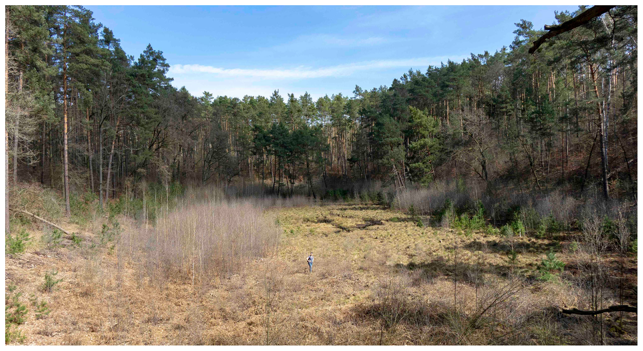
Figure 9Northward view across the Large Mire of Ferch (52∘18.35′ N, 12∘54.88′ E), including about 10 m of gyttjas and peats of late glacial to Holocene age (Rowinsky, 1995) (photo: Bernhard Diekmann, 2020).
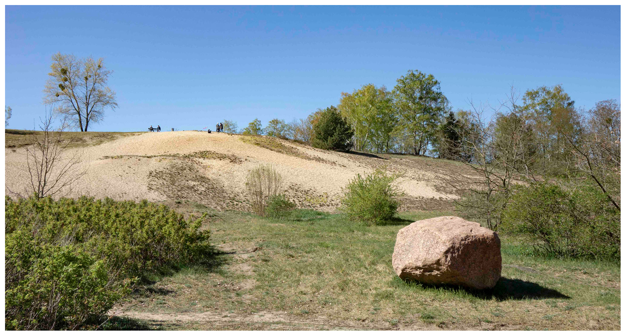
Figure 10View of the eastern slope of Krähenberg in Caputh (52∘20.4′ N, 12∘59.3′ E), a kame landform that is built up of gravelly sands (photo: Bernhard Diekmann). The glacial granite boulder is of local origin and has been put there for decoration.
4.4 Stop 4: Caputh
The village of Caputh (33 m a.s.l.) lies at the constriction of the locally channelized Havel River, connecting Lake Templin to the northeast with Lake Schwielow to the southwest (Fig. 3). Since 1853, a cable ferry has crossed the river course. Caputh, with its more than 5000 inhabitants, was first mentioned in 1317 and in the 19th century became an important spot of inland navigation for the shipping of bricks from the Glindow area. Historic buildings, such as the Caputh Palace (1662) and the church (1852), the latter built according to plans of the renowned architect Friedrich August Stüler, are eye-catchers in the centre of the village. In the last century, Caputh developed into a summer residence for wealthy families from Berlin and Potsdam. Between 1929 and 1932, Albert Einstein was a prominent visitor, who used to spend his summer holidays (Sommerfrische in German) in a wooden mansion before he emigrated from Germany (Schwielowsee Tourismus, 2022).
The 500 × 700 m Krähenberg (85 m a.s.l.) rises 40 m above the lower part of the village of Caputh. The hill represents the northeastward continuation of the lateral moraine of Wietkiekenberg (125 m a.s.l.) in Ferch and shows signs of ice pressing at its base (Weiße, 2001). The upper sediments of Krähenberg consist of clast-bearing sands, interpreted as thaw sediments in a kame setting. Glacial clasts comprise the typical spectrum of Nordic origin with crystalline components and quartzite as well as chert and flint fragments from Scandinavia and the Baltic Sea. The sediments are well exposed on the steep eastern flank of the hill, covered by dry grasses and few trees (Fig. 10).
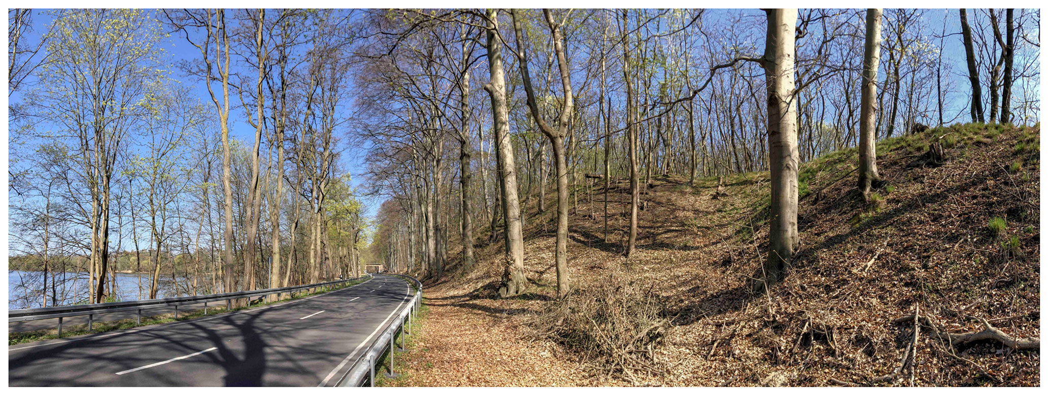
Figure 11Northward view along the eastern shore of Lake Templin with the former ice-contact slope and periglacial dry valley to the right (52∘21.55′ N, 13∘01.55′ E) (photo: Bernhard Diekmann, 2020).
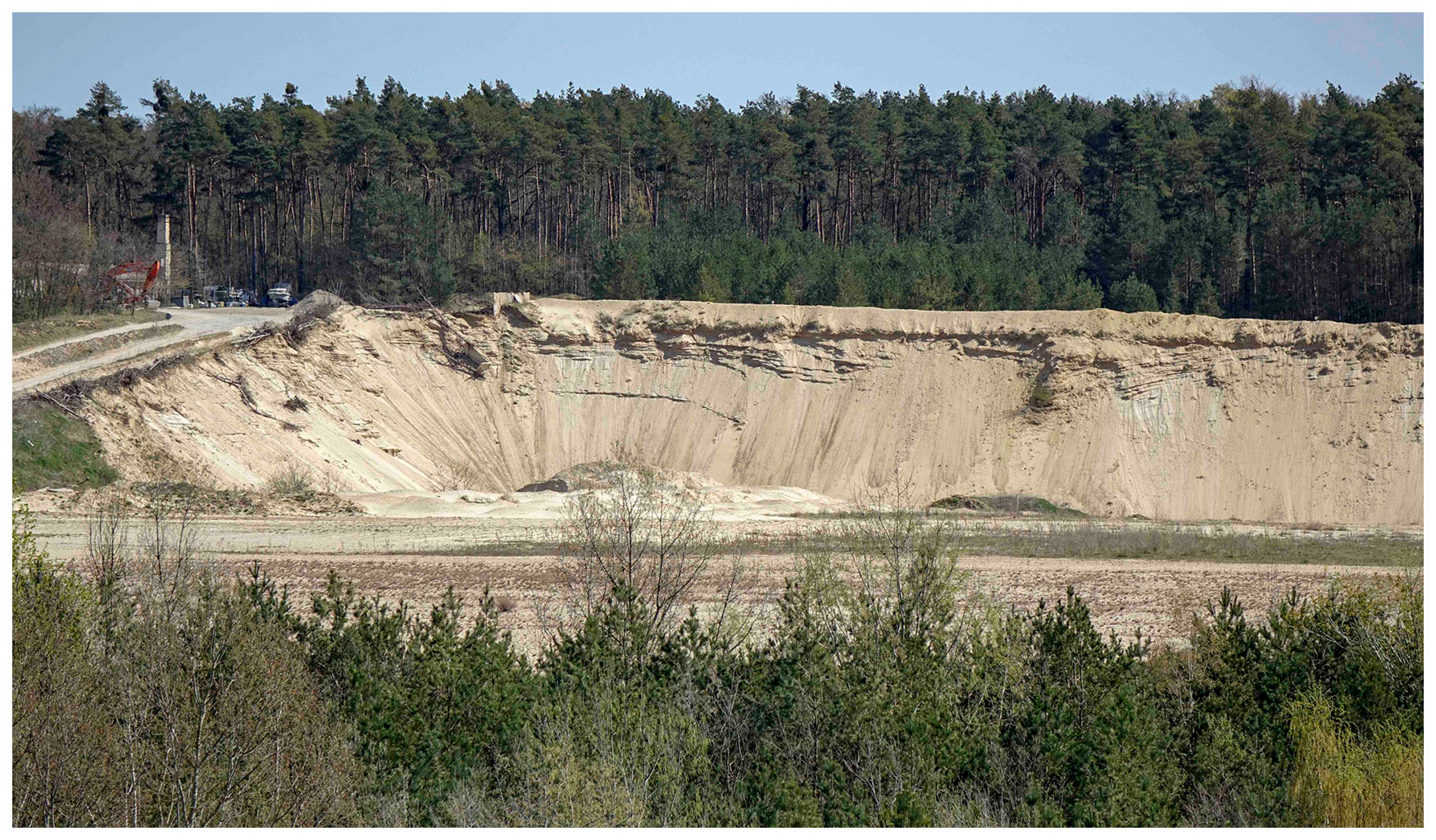
Figure 12Eastward view into a sandpit of the kame terrace east of Lake Templin (photo: Bernhard Diekmann, 2020). Image was taken from the western margin of the terrace (52∘21.9′ N, 13∘01.8′ E), close to Lake Templin.
The top position on the hill offers a panoramic view across the glacial landscape around Caputh. The ridges of the Ravensberge (up to 114 m a.s.l.) towards the east mark the lateral push moraines of the Brandenburg Stage bordered to the west by a kame terrace of the meltdown stage (Potsdamer Heide, 70–80 m a.s.l.). The foreground to the east is occupied by Lake Caputh (31 m a.s.l.), directly located at the former ice-contact slope of the kame terrace. Lake Caputh as a typical kettle lake structure is part of a former (subglacial) meltwater valley heading towards the southwest. The Krähenberg and Wietkiekenberg axis apparently formed a morphological divide between the glacial lobe of the Lake Schwielow depression located to the west and the valley of Lake Caputh. The background to the west shows the hummocky kame landscape at the western shores of Lake Schwielow around Petzow as well as the outflow of the Havel River to the northwest; in the background, the small town of Werder with adjacent fruit yards can be seen.
4.5 Stop 5: Lake Templin
The way back to Potsdam takes the road along the eastern bank of Lake Templin, which is bordered by a steep, 20 to 30 m high slope, documenting former ice contact at the margin of an extensive kame terrace, already seen in the background of Stop 4 in Caputh (Weiße, 2001; Hermsdorf, 2005). The up to 4 km wide outwash plain (60–75 m a.s.l.) formed during the meltdown stage between the morainic ridges of the Ravensberge (114 m a.sl.) and the Havel River (30 m a.s.l.) and stretches from Potsdam to Caputh (Figs. 3, 4). After final deglaciation, the ice-marginal slope was sculptured by periglacial processes, leaving behind dry valleys and gullies (Fig. 11). The adjacent Havel River is underlain by a postglacial basin, filled with up to 45 m thick gyttjas (Fig. 4).
The clastic sediments of the kame terrace represent important raw materials, which since the 1960s have been exploited for the building industry. A mining pit is located directly north of the railway track between the road to Michendorf and Lake Templin (52∘21.7′ N, 13∘02.3′ E) (Figs. 3, 12). Today, the outcrop situation is not satisfying for field description. Former studies have reported a more than 20 m thick section of fine- to medium-grained sands with up to 7 % gravel contents. Most of the sands are current-bedded, pointing to transport directions towards the remaining ice lobes to the west and southwest (Weiße, 2001, 2012a). Postdepositional faulting is a sign of sagging with the loss of ground ice and the meltdown of adjacent ice bodies.
The railway track through the sand deposits and across the Havel Bridge is part of the railway ring, constructed in the mid-1950s (Bley, 2016). It was a technical and engineering challenge because the Havel riverbed not only had thick layers of sludge but was also very inhomogeneous due to deep pools. The bog blasting method was used, by means of which the stabilizing sand fill could be brought down to the load-bearing subsoil by means of loosening blasting.
The road along Lake Templin leads us back to Potsdam, and the tour finishes at the base of the Telegrafenberg, which forms part of one of the pronounced push moraines of the Brandenburg Stage and is the venue of the DEUQUA Conference 2022.
No data sets were used in this article.
Under the coordination of BD as corresponding and leading author, WS, RW, MB, UR, BB, and AB have contributed text and their expertise on regional geology to the article. Contributions to illustrations are specified in the captions of the figures.
The contact author has declared that none of the authors has any competing interests
Publisher’s note: Copernicus Publications remains neutral with regard to jurisdictional claims in published maps and institutional affiliations.
We sincerely thank Gerd W. Lutze (Märkische Eiszeitstraße e.V., Eberswalde, Germany), who kindly provided the landscape map in Fig. 4.
Bley, P.: Von der Güterumgehungsbahn zum Berliner Außenring, Band 2: Entwicklung 1945–1961, VBN Verlag Bernd Neddermeyer GmbH, 243 pp., ISBN 978-3-941712-52-2, 2016.
Böse, M. and Brande, A.: Die pleistozäne und holozäne Entwicklung im nördlichen Bereich des Beelitzer Sanders, in: Exkursionsführer: Deuqua 2002, edited by: Reißmann, C. and Böse, M., Mensch, Klima, Landschaft, 156–170, 2002.
Böse, M., Müller, M., Brande, A., and Facklam, M.: Jungdünenentwicklung und Siedlungsgeschichte auf der Glindower Platte (Brandenburg), Brandenburgische Geowissenschaftliche Beiträge, 9(1/2), 45–57, 2002.
Böse, M., Lüthgens, C., Lee, J. R., and Rose, J.: Quaternary glaciations of northern Europe, Quaternary Sci. Rev., 44, 1–25, https://doi.org/10.1016/j.quascirev.2012.04.017, 2012.
Böse, M., Ehlers, J., and Lehmkuhl, F.: Deutschlands Norden vom Erdaltertum zur Gegenwart, Springer, Berlin, Germany, 209 pp., https://doi.org/10.1007/978-3-662-55373-2, 2018.
Brande, A. and Rowinsky, V.: Moore als Archive, ein Inventar aus den “Fercher Bergen” bei Potsdam (Brandenburg), Telma, 47, 45–74, 2017.
Brande, A., Böse, M., Müller, M., Facklam, M., and Wolters, S.: The Bliesendorf soil and aeolian sand transport in the Potsdam area, GeoArchaeoRhein, 3, 147–161, 1999.
Brauer, A., Tempelhoff, K., and Murray, A.: OSL dating of fine-grained sand deposits and its Implications for glacial stratigraphy and landscape evolution: research results from Stolzenhagen, northeastern Brandenburg, Die Erde – Contributions to Physical Geography, 136, 15–35, 2005.
Cepek, A. G.: Die Stratigraphie der pleistozänen Ablagerungen im Norddeutschen Tiefland, in: Die Weichsel-Eiszeit im Gebiet der Deutschen Demokratischen Republik, edited by: Gellert, J. F., Akademie-Verlag, Berlin, Germany, 45–65, 1965.
Dienemann, W.: Kaolin, Ton, Sand, Kies, Wiesenkalk, Kieselgur, in: Die nutzbaren Gesteine Deutschlands und ihre Lagerstätten mit Ausnahme der Kohlen, Erze und Salze, Band 1, edited by: Dienemann, W. and Burre, O., Ferdinand Enke, Stuttgart, 418 pp., 1928.
Grunewald, K. and Marcinek, J. (Eds.): Berlin-Potsdamer Stadtrandlandschaften; Landschaftspflege, Naturschutz, geographische Streifzüge, Stapp-Verlag, Berlin, Germany, 188 pp., ISBN 9783877760635, 1995.
Hardt, J. and Böse, M.: The timing of the Weichselian Pomeranian ice marginal position south of the Baltic Sea: A critical review, Quatern. Int., 478, 51–58, https://doi.org/10.1016/j.quaint.2016.07.044, 2016.
Hardt, J., Lüthgens, C., Hebenstreit, R., and Böse, M.: Geochronological (OSL) and geomorphological investigations at the presumed Frankfurt ice marginal position in northeast Germany, Quaternary Sci. Rev., 154, 85–99, 2016.
Hermsdorf, N.: Geologische Übersichtskarte 1 : 100 000 mit Beiheft, Landkreis Potsdam-Mittelmark Kreisfreie Stadt Potsdam, kreisfreie Stadt Brandenburg an der Havel, Nr. 8, Landesamt für Bergbau, Geologie und Rohstoffe Brandenburg in Zusammenarbeit mit der Landesvermessung und Geobasisinformation Brandenburg, Kleinmachnow, 24 pp., 2005.
Horn, G.: The WHS' Palaces and Parks of Potsdam and Berlin in Germany, how to manage a site taking numerous points-of-view into consideration, Proceedings of the scientific Symposium “Monuments and sites in their setting conserving cultural heritage in changing townscapes and landscapes”, ICOMOS 15th General Assembly and scientific Symposium, 17–21 October 2005, Xi'an, China, 15 pp., https://openarchive.icomos.org/id/eprint/325/ (last access: 21 July 2022), 2005.
Hughes, A. L. C., Gyllencreutz, R., Lohne, Ø. S., Mangerud, J., and Svendsen, J. I.: The last Eurasian ice sheets – a chronological database and time-slice reconstruction, DATED-1, Boreas, 45, 1–45, https://doi.org/10.1111/bor.12142, 2015.
Juschus, O.: Der maximale Vorstoß des weichselzeitlichen Inlandeises am Nordrand des Lausitzer Grenzwalls und des Flämings, Brandenburger geowissenschaftliche Beiträge, 10, 63–73, 2010.
Kaiser, K., Hilgers, A., Schlaak, N., Jankowski, M., Kühn, P., Bussemer, S., and Przegietka, K.: Palaeopedological marker horizons in northern central Europe: Characteristics of Lateglacial Usselo and Finow soils, Boreas, 38, 591–609, https://doi.org/10.1111/j.1502-3885.2008.00076.x, 2009.
Kaiser, K., Keller, N., Brande, A., Dalitz, S., Hensel, N., Heußner, K.-U., Kappler, C., Michas, U., Müller, J., Schwalbe, G., Weiße, R., and Bens, O.: A large-scale medieval dam-lake cascade in central Europe: Water level dynamics of the Havel River, Berlin-Brandenburg region, Germany, Geoarchaeology, 33, 237–259, https://doi.org/10.1002/gea.21649, 2017.
Knothe, D.: Luchland zwischen Linum und Fehrbellin, in: Berlin-Potsdamer Stadtrandlandschaften, Landschaftspflege, Naturschutz, Geographische Streifzüge, edited by: Grunewald, K. and Marcinek, J., Stapp-Verlag, Berlin, Germany, 76–93, ISBN 9783877760635, 1995.
Kramm, H. J. (Ed.): Der Bezirk Potsdam, Geographische Exkursionen (3. Auflage), Verlag VEB Hermann Haack, Gotha, 196 pp., ISBN 3-7301-0602-3, 1989.
Krbetschek, M. R., Degering, D., and Alexowsky, W.: Infrarot-Radiofluoreszenz-Alter (IR-RF) unter-saalezeitlicher Sedimente Mittel- und Ostdeutschlands, Z. Dtsch. Ges. Geowiss., 159, 133–140, 2008.
Lange, I.: Die historische KulturlandschaftPotsdams, eine denkmalpflegerische Untersuchung am Beispiel des inneren Westraumes, ISR Impulse Online, Universitätsverlag der TU Berlin, 60, 188 pp., https://doi.org/10.14279/depositonce-5391, 2016.
LGB: BrandenburgViewer, Digitales Geländemodell, Landesvermessung und Geobasisinformation Brandenburg (LGB), https://bb-viewer.geobasis-bb.de/, last access: 9 May 2020.
Lippstreu, L., Hermsdorf, N., Sonntag, A., and Strahl, J.: Pleistozän, in: Geologie von Brandenburg, edited by: Stackebrandt, W. and Franke, D., Schweizerbart, Stuttgart, Germany, 333–418, ISBN 978-3510652952, 2015.
Litt, T., Behre, K.-E., Meyer, K.-D., Stephan, H.-J., and Wansa, S.: Stratigraphische Begriffe für das Quartär des norddeutschen Vereisungsgebietes, E&G Quaternary Sci. J., 56, 7–65, https://doi.org/10.3285/eg.56.1-2.02, 2007.
Lüthgens, C. and Böse, M.: From morphostratigraphy to geochronology – on the dating of ice marginal positions, Quaternary Sci. Rev., 44, 26–36, https://doi.org/10.1016/j.quascirev.2010.10.009, 2012.
Lüthgens, C., Böse, M., and Krbetschek, M. R.: On the age of the young morainic morphology in the area ascribed to the maximum extent of the Weichselian glaciation in north-eastern Germany, Quatern. Int., 222, 72–79, 2010a.
Lüthgens, C., Krbetschek, M., Böse, M., and Fuchs, M. C.: Optically stimulated luminescence dating of fluvioglacial (sandur) sediments from north-eastern Germany, Quat. Geochronol., 5, 237–243, 2010b.
Lüthgens, C., Böse, M., and Preusser, F.: Age of the Pomeranian ice-marginal position in northeastern Germany determined by Optically Stimulated Luminescence (OSL) dating of glaciofluvial sediments, Boreas, 40, 598–615, https://doi.org/10.1111/j.1502-3885.2011.00211.x, 2011.
Lüthgens, C., Hardt, J., and Böse, M.: Proposing a new conceptual model for the reconstruction of ice dynamics in the SW sector of the Scandinavian Ice Sheet (SIS) based on the reinterpretation of published data and new evidence from optically stimulated luminescence (OSL) dating, E&G Quaternary Sci. J., 69, 201–223, https://doi.org/10.5194/egqsj-69-201-2020, 2020.
Lutze, G. W.: Naturräume und Landschaften in Brandenburg und Berlin, Gliederung, Genese und Nutzung, be.bra wissenschaftsverlag GMbH, Berlin, 159 pp., ISBN 978-3-95410-030-9, 2014.
Meschede, M. and Warr, L. N.: The geology of Germany, a process-oriented approach, Springer Nature Switzerland AG, 304 pp., https://doi.org/10.1007/978-3-319-76102-2, 2019.
MLUL: Wälder Brandenburgs, Ergebnisse der ersten landesweiten Waldinventur, Ministerium für Ländliche Entwicklung, Umwelt und Landwirtschaft, Land Brandenburg, 36 pp., https://mluk.brandenburg.de/mluk/de/ueber-uns/oeffentlichkeitsarbeit (last access: 15 July 2022), 2015.
Nillert, P., Schäfer, D., and Zühlke, K.: Auswirkungen der regionalen Klimaentwicklung auf die Wasserversorgung am Beispiel Wasserwerk Potsdam Leipziger Straße, GWF Wasser-Abwasser, 149, 948–955, 2008.
Rinterknecht, V., Braucher, R., Böse, M., Bourles, D., and Mercier, J. L.: Late Quaternary ice sheet extents in northeastern Germany inferred from surface exposure dating, Quaternary Sci. Rev., 44, 89–95, 2012.
Rowinsky, V.: Hydrologische und stratigraphische Studien zur Entwicklungsgeschichte von Brandenburger Kesselmooren, Berliner Geographische Abhandlungen, 60, 1–155, 1995.
Rubin, M., Brande, A., and Zerbe, S.: Ursprüngliche, historisch anthropogene und potenzielle Vegetation bei Ferch (Gemeinde Schwielowsee, Landkreis Potsdam-Mittelmark), Naturschutz und Landschaftspflege in Brandenburg, 17, 14–22, 2008.
Schroeder, J. H. (Ed.): Führer zur Geologie von Berlin und Brandenburg, Nr. 4: Potsdam und Umgebung (2nd edition), Selbstverlag Geowissenschaftler in Berlin und Brandenburg e. V., Berlin, Germany, 275 pp., ISBN 978-3928651097, 2001.
Schroeder, J. H., Lippstreu, L., Weiße, R., Ziermann, H., and Zwirner, R.: Das Quartär, in: Führer zur Geologie von Berlin und Brandenburg, Nr. 4, Potsdam und Umgebung, 2nd edn., edited by: Schroeder, J. H., Selbstverlag Geowissenschaft/er in Berlin und Brandenburg, Berlin, Germany, 16–38, ISBN 978-3928651097, 2001.
Schwielowsee Tourismus: Einsteinhaus Caputh, https://www.schwielowsee-tourismus.de/kunst-kultur/museen/detailinformationen.html?uri=havelland/museen/albert-einstein-haus/&gb=16252, last access: 15 July 2022.
Stackebrandt, W.: Subglacial channels of Northern Germany – a brief review, Z. Dtsch. Ges. Geowiss., 160, 203–210, https://doi.org/10.1127/1860-1804/2009/0160-0203, 2009.
Stackebrandt, W.: Mehr als nur die “Streusandbüchse”, zur Erdgeschichte von Brandenburg, 2nd edition, geogen (Eigen-)Verlag, Potsdam, 140 pp., ISBN 978-3000664229, 2020.
Stackebrandt, W. and Franke, D. (Eds.): Geologie von Brandenburg, Schweizerbart, Stuttgart, 805 pp., ISBN 978-3-510-65295-2, 2015.
Stackebrandt, W. and Manhenke, V. (Eds): Atlas zur Geologie von Brandenburg 1 : 1 000 000, Landesamt für Geowissenschaften und Rohstoffe Brandenburg, Kleinmachnow, Germany, 143 pp., ISBN 978-3980815710, 2004.
Viehrig, H.: Potsdam, geographische Strukturen im Wandel, Potsdamer Geographische Forschungen, 22, Audiovisuelles Zentrum der Universität Potsdam, 258 pp., ISBN 978-3-935024-52-5, 2002.
Weiße, R.: Genese und glaziärer Baustil der Potsdamer Seenlandschaft, Petermanns Geographische Mitteilungen, 1991, 39–48, 1991.
Weiße, R.: Die Potsdamer Havelseenkette, in: Berlin-Potsdamer Stadtrandlandschaften, Landschaftspflege, Naturschutz, Geographische Streifzüge, edited by: Grunewald, K. and Marcinek, J., Stapp-Verlag, Berlin, Germany, 38–63, ISBN 978-3877760635, 1995.
Weiße, R.: Oberflächennahe Glazialgeologie und Geomorphologie, in: Führer zur Geologie von Berlin und Brandenburg, Nr. 4, Potsdam und Umgebung, 2nd edition, edited by: Schroeder, J. H., Selbstverlag Geowissenschaft/er in Berlin und Brandenburg, Berlin, Germany, 43–78, ISBN 978-3928651097, 2001.
Weiße, R.: Weichselzeitliche Sedimente, Strukturen und Oberflächenformen Potsdams, in: Preußens Telegraphenlinie Berlin-Koblenz und Beiträge zur Geschichte und Geologie des Potsdamer Telegraphenbergs und seiner Umgebung, Telegraphenbuch III, edited by: Menning, M. and Hendrich, A., GFZ, Potsdam, 56–99, 2012a.
Weiße, R.: Zur Geologie und Geographie der optisch-mechanischen Telegraphenstationen im Land Brandenburg Nr. 4 Potsdam bis Nr. 9 Zitz, in: Preußens Telegraphenlinie Berlin-Koblenz und Beiträge zur Geschichte und Geologie des Potsdamer Telegraphenbergs und seiner Umgebung, Telegraphenbuch III, edited by: Menning, M. and Hendrich, A., GFZ, Potsdam, 42–55, 2012b.
Wolters, S.: Spät- und postglaziale Vegetationsentwicklung im Bereich der Fercher Berge südwestlich von Potsdam, Gleditschia, 1–2, 25–44, 1999.