 | 15 Sep 2022
Ice dynamics in the SW sector of the Scandinavian Ice Sheet (SIS) – a fresh perspective from the classical area of the Weichselian glaciation in northern Brandenburg
Christopher Lüthgens
Jacob Hardt
Lüthgens, C. and Hardt, J.: Ice dynamics in the SW sector of the Scandinavian Ice Sheet (SIS) – a fresh perspective from the classical area of the Weichselian glaciation in northern Brandenburg, DEUQUA Spec. Pub., 4, 29–39, https://doi.org/10.5194/deuquasp-4-29-2022, 2022.
The glacial landscape of northern Brandenburg, especially the Eberswalde–Chorin area, is one of the most important study areas of Quaternary research in northern Germany, not only with respect to its research history, but especially with regard to new mapping, sedimentological logging, and dating results using up-to-date methodologies. These new results have added an important puzzle-piece contributing to the development of a new concept of ice dynamics in the SW sector of the Scandinavian Ice Sheet (SIS) during Marine Isotope Stage 2 (MIS 2). After an introduction to the glacial geomorphology of the area, key sites visited during the field trip are explained, and the recent results are introduced and discussed.
- Article
(34533 KB) - Full-text XML
- BibTeX
- EndNote


The glacial landscape of north-eastern Germany has been one of the type areas in Quaternary research ever since the first steps towards a consistent glacial theory were taken in the second half of the 19th century (summarised in Lüthgens and Böse, 2011). Notwithstanding this important role in research history, the area has experienced a boost in scientific relevance throughout the last decade(s), now being one of the areas providing the most comprehensive geochronological record for the last glacial cycle in the south-western sector of the Scandinavian Ice Sheet (SIS; summarised in Lüthgens et al., 2020). An important point that makes the area particularly suitable for such research is the fact that especially in Brandenburg, the ice-marginal positions of the Weichselian glaciation are not only developed well north of the maximum extent of the penultimate glaciation (Fig. 1) but were in fact also developed well apart from each other (Fig. 2), allowing for a relatively straightforward assignment of landforms and sediments to specific ice advances. The aim of this field trip was to demonstrate the exceptionally well-preserved and textbook-like geomorphology and sedimentology of the glacial series (Glaziale Serie) of the Pomeranian (W2) ice-marginal position in the Eberswalde–Chorin area, contrasting it with the challenging geomorphological and sedimentological record of the area assigned to the “vanishing” Frankfurt (W1F) ice-marginal position. Over the last years, several geomorphological and geochronological studies applying up-to-date methodology (Lüthgens et al., 2011, 2010a, b; Lüthgens and Böse, 2011, 2012; Hardt et al., 2015, 2016, 2021; Hardt and Böse, 2016; Heine et al., 2009; Brauer et al., 2005; Rinterknecht et al., 2006, 2012) in that broader area have generated important results, which have significantly contributed to a new understanding of the ice dynamics and glacial landscape development in north-eastern Germany (Lüthgens et al., 2020). Consequently, the route of the field trip (Fig. 3) started on a drumlin-shaped elevation, the “Kleiner Rummelsberg”, north of the W2 ice-marginal position, leading to the terminal moraines of the global Last Glacial Maximum (G-LGM) at the Ihlowberge and Sperlingsherberge sites, to the area of the LGM proglacial outwash plains in an ice-proximal setting at the Althüttendorf gravel pit, and to the ice-proximal site of the Macherslust site. Leaving the area of the G-LGM, the route then leads to the Albertshof and Ladeburg sites (Fig. 3), where the ice dynamics and landscape development are associated with the ice advance to the local LGM (L-LGM), which reached its maximum position well south of the field trip area at the Brandenburg ice-marginal position (W1B), and its subsequent decay is discussed. The aim of the field trip was to demonstrate that, rooted in a long tradition of research, applying up-to-date methodology and integrating results from geomorphology, sedimentology, and geochronology (Lüthgens et al., 2020) have changed the view on and initiated a fresh and fruitful discussion about the dynamics of the south-western sector of the SIS in the last glacial cycle.
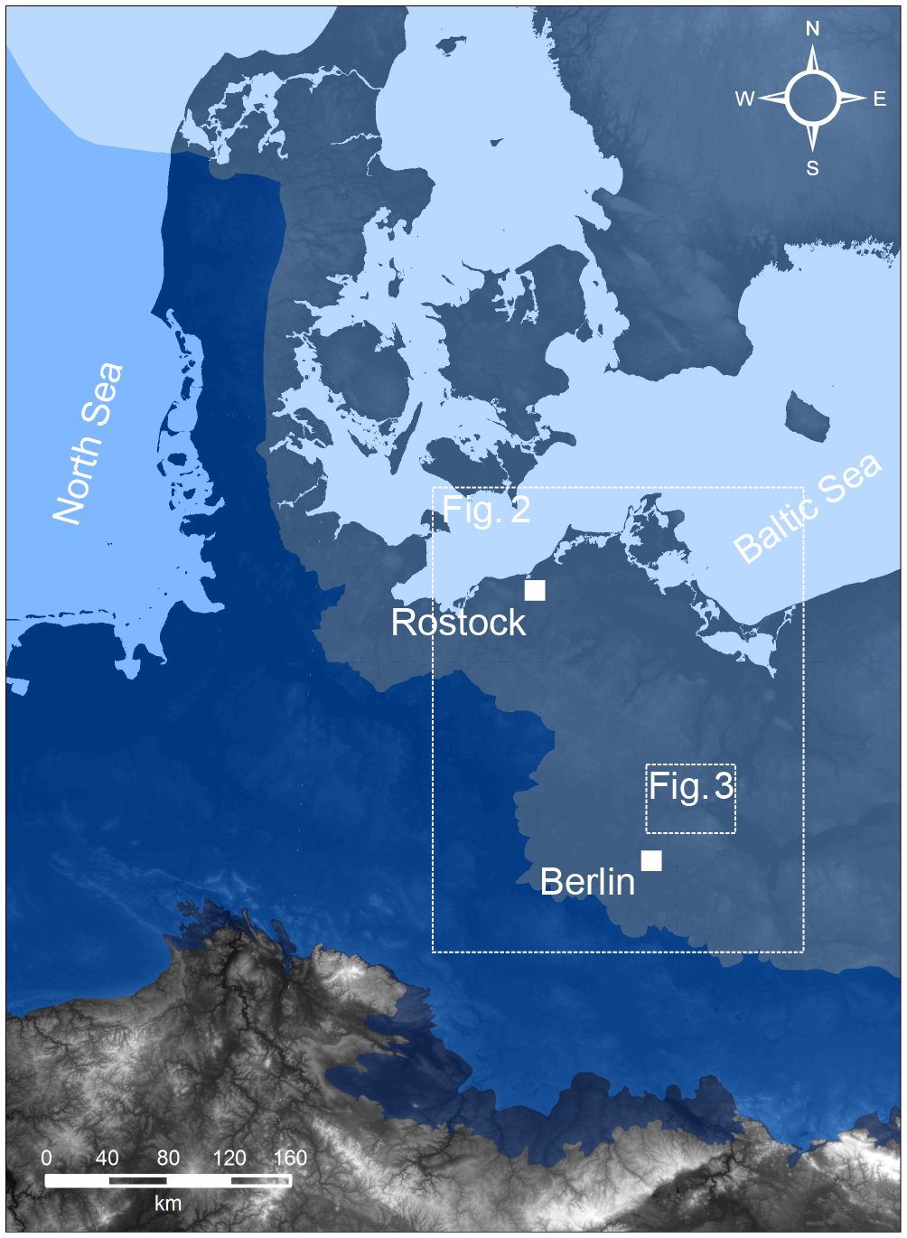
Figure 1Maximum extents of the Elsterian (dark blue), Saalian (blue), and Weichselian (light blue) glaciations (from south to north) in the south-western sector of the SIS (figure modified from Lüthgens and Böse, 2011; data from Ehlers and Gibbard, 2004).

Figure 2Ice-marginal positions in north-eastern Germany and north-western Poland according to the (traditional) morphostratigraphic system (based on Liedtke, 1981). The existence of an W1F ice-marginal position has been challenged based on results from recent research (presented during the field trip) and is only included here as a dotted line with question marks for spatial reference (figure modified from Lüthgens and Böse, 2011).

Figure 3Overview map of the route of the field trip with waypoints to be visited. (1) Kleiner Rummelsberg (geomorphological overview), (2) Ihlowberge–Sperlingsherberge (terminal moraines of the Pomeranian stage), (3) Althüttendorf gravel pit (ice-proximal sandur sediments), (4) Macherslust clay pit (banded silts and clays), (5) Albertshof gravel pit (the vanishing of an ice-marginal position – part 1), (6) Ladeburg gravel pit (the vanishing of an ice-marginal position – part 2). Hydrology: © OpenStreetMap contributors 2022. Distributed under the Open Data Commons Open Database License (ODbL) v1.0.
Situated in the glacial basin of an ice lobe that formed the terminal moraines framing the area of the Parstein lake (“Parsteiner See”), the 82 m high elevation of the Kleiner Rummelsberg (52.912955∘ N, 13.981974∘ E) provides an excellent viewpoint to gain an overview of the typical glacial geomorphology of the area (Fig. 4). To the west, south, and east, the view is framed by the G-LGM terminal moraines of the Pomeranian stage (“Parsteiner Bogen”), while the direct surroundings of the Kleiner Rummelsberg itself are dominated by multiple lakes, which developed in the depression of the glacial basin (Gletscherzungenbecken in terms of the classical glacial series; Fig. 5). Towards the north, the view is open and shows the transition of the lake-dominated basin to the hummocky areas of the till plain associated with the G-LGM ice advance. Apart from the Kleiner Rummelsberg itself, multiple hills are present within the glacial basin. The processes that formed these hills have been controversially discussed. Originally, they were interpreted to represent a local, recessional ice-marginal position, formed during the retreat of the ice front from the terminal moraine of the Parsteiner Bogen (Brose, 1978). However, some of the insular hills like the Kleiner Rummelsberg itself have an elongated, drumlin-like shape, which may likely indicate that these hills may represent older landforms, which have been overridden by the L-LGM advance of the Parstein ice lobe to the Pomeranian ice-marginal position.

Figure 4Views from the top of Kleiner Rummelsberg: (a) view to the south-east, showing the W2 terminal moraines of the Parsteiner Bogen in the background and the streamlined, drumlin-like topography in the foreground (photo by Christopher Lüthgens, 2007). (b) View to the south–south-west, showing again the W2 terminal moraines in the background and recessional moraines bordering the shore of Wesensee (photo: Christopher Lüthgens, 2007; modified from Lüthgens and Böse, 2011).
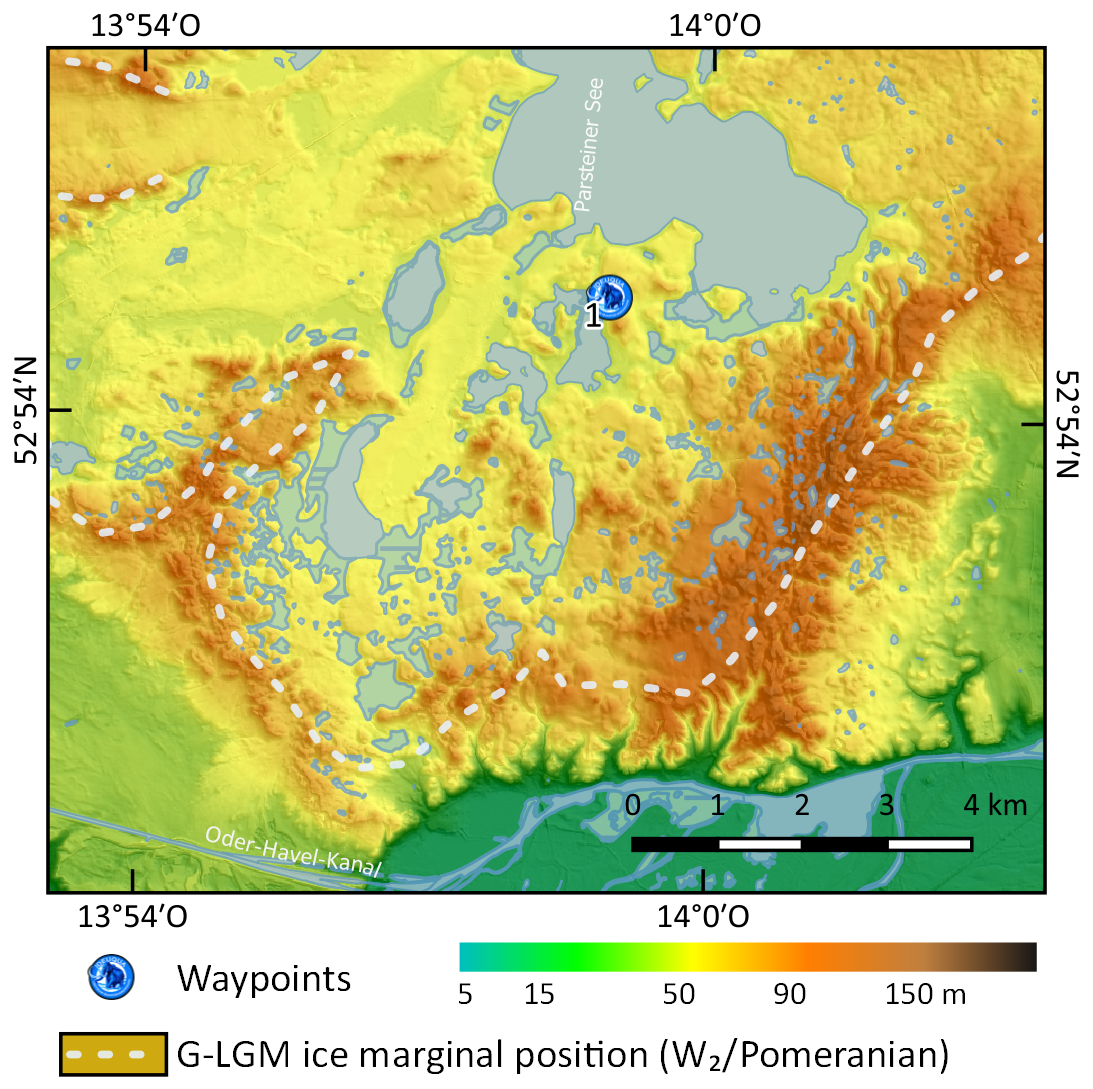
Figure 5DEM of the Gletscherzungenbecken surrounded by the G-LGM terminal moraines of the Parsteiner Bogen (W2). Waypoint 1: Kleiner Rummelsberg. Map projection: UTM 33∘ N; coordinate system: WGS 84; terrain model: Laserscan (GeoBasis-DE/LGB, 2020); hydrology: © OpenStreetMap contributors 2022. Distributed under the Open Data Commons Open Database License (ODbL) v1.0.
Within the Brandenburg area, the terminal moraines of the Pomeranian ice-marginal position are not only very clearly geomorphologically expressed, they are also rather exceptional with respect to the high content of boulders within the sediment building the terminal moraines (Blockpackung). Lacking any alternative hard-rock resources, these boulder-rich sediments were discovered early on as a raw material source, spawning a quarry industry in the mid-18th century. The sites Ihlowberge (52.959169∘ N, 13.836481∘ E) and Sperlingsherberge (52.972477∘ N, 13.855360∘ E; Fig. 6) are both abandoned quarries from that time and today offer access to the sediments of the Pomeranian terminal moraines (Hultzsch, 1994), showing the rare Blockpackungen (Fig. 7). Both sites are also part of the “Geopark Eiszeitland am Oderrand” (roughly translating to geopark for the “ice age landscape adjacent to the Oder River”). Information with regard to the geopark can be accessed via the park's website https://www.geopark-eiszeitland.de/ (last access: 28 July 2022).
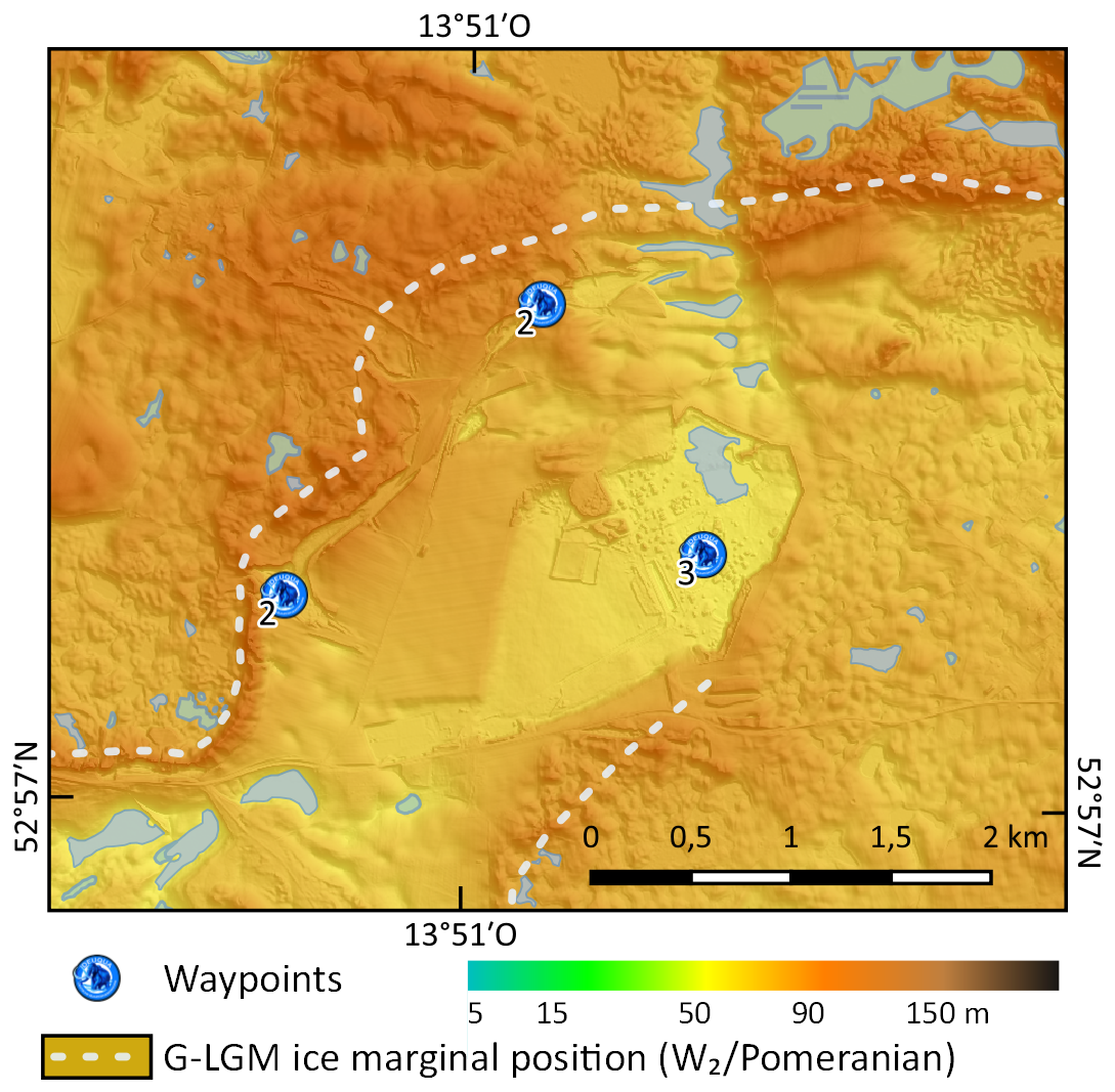
Figure 6DEM of the Althüttendorf area. (2) Blockpackungen of Ihlowberge (north) and Sperlingsherberge (south), (3) Althüttendorf gravel pit. Map projection: UTM 33∘ N; coordinate system: WGS 84; terrain model: Laserscan (GeoBasis-DE/LGB, 2020); hydrology: © OpenStreetMap contributors 2022. Distributed under the Open Data Commons Open Database License (ODbL) v1.0.
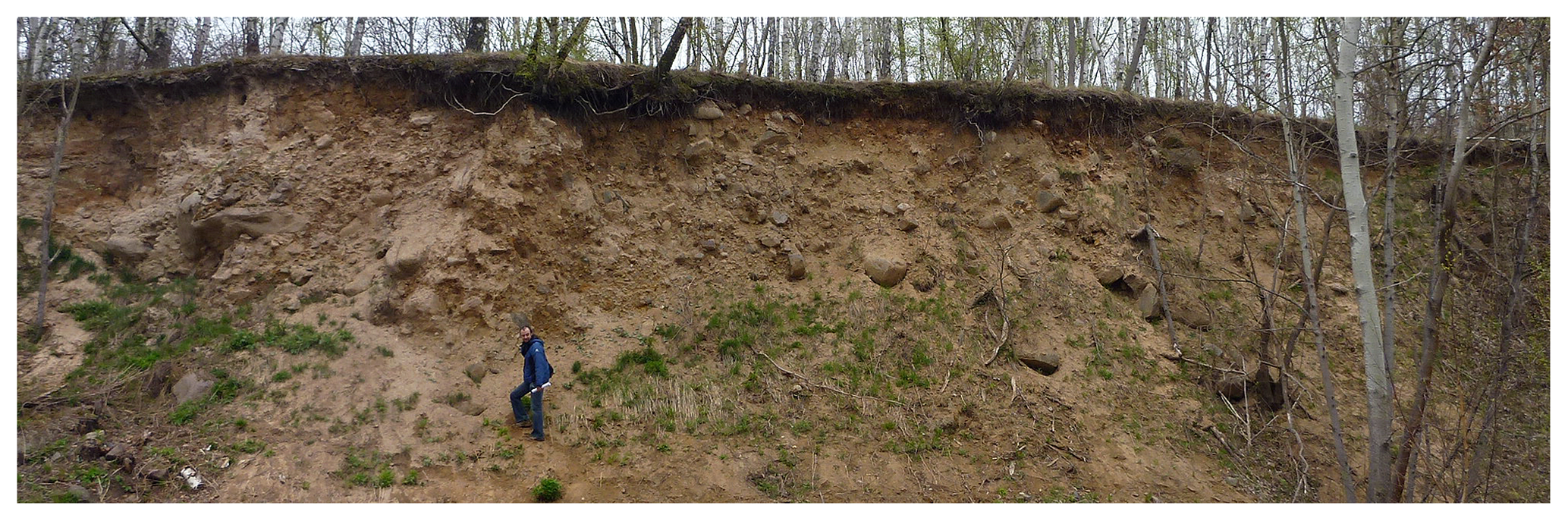
Figure 7Outcrop in the terminal moraines at the abandoned quarry of “Sperlingsherberge” showing the high content of blocks (Blockpackung). However, the characteristics of the proglacially deposited diamicton building the terminal moraines vary between matrix- and clast-supported segments and also include segments of glaciofluvial sediments (photo: Margot Böse, 2011).
Boulders from the terminal moraine surface were among the first to be dated by means of surface exposure dating (SED) using cosmogenic nuclides (specifically 10Be) in north-eastern Germany (Heine et al., 2009). Methodological advances in cosmogenic nuclide dating required a recalculation of these ages, which was conducted by Hardt and Böse (2016), resulting in ages around 18–20 ka, indicating the retreat of the ice front from its G-LGM position at that time.
Figure 8 shows that the terminal moraines of the G-LGM create an interlobate area framed by the terminal moraines of the “Joachimsthaler Bogen”, which functioned as a main meltwater drainage, resulting in the deposition of the sediments forming the Althüttendorf outwash plain (“Althüttendorfer Sander”, named by the nearby village). This outwash plain is part of the complex pattern of intercalated glaciofluvial sedimentary units south of the Pomeranian ice-marginal position (summarised in Lüthgens et al., 2011), analysed in detail by Krambach and Böse (2017). Figure 8 summarises the major routes of meltwater and related glaciofluvial outwash deposits in the area. While the main discharge from the Althüttendorf area was most likely routed south-west via the Werbellinsee depression, smaller fan-shaped outwash cones seam the southern margins of the Pomeranian terminal moraines. The fans form the Ragöse, Amtsweg, and Klosterbrücke sandurs and indicate restricted meltwater activity in the Eberswalde ice-marginal valley as opposed to previous interpretations by, for example, Liedtke (1956) or Börner (2007) at that time (Krambach and Böse, 2017). The meltwaters which where drained through the glaciofluvial gap in the area of the Chorin Monastery originated from a recessional ice margin north of the Pomeranian terminal moraines (like the Angermünde and Parstein subphases). The exact drainage and routing of these meltwaters is still under debate, but Krambach and Böse (2017) show that the Eberswalde ice-marginal valley did not drain significant amounts of meltwater during that time as well. This makes a rerouting of meltwater as proposed by, for example, Liedtke (1956) and Kozarski (1966) more likely and challenges the previously established model based on a glaciofluvial terrace system in the Eberswalde ice-marginal valley (summarised by Gärtner et al., 1995).

Figure 8Simplified depiction of meltwater discharge in the field trip area (based on Fig. 2 of Lüthgens et al., 2011), incorporating the new results from Krambach and Böse (2017). Meltwater from the area of the Pomeranian ice-marginal position (shaded red area; terminal moraines indicated by the dashed red line) was mainly drained from the Althüttendorf area around higher terrain formed by previous Weichselian (orange shaded areas; or even Saalian (purple shaded areas; S) ice advances to the south-west and south-east. Outwash deposition was otherwise mostly limited to fans in front of the terminal moraines (yellow arrows). Final outwash drainage and deposition of meltwater deposits associated with the Pomeranian ice-marginal position are documented in the outwash fan of “Klosterbrücke” (bright-red arrows). After the ice front had retreated to recessional stages further north, meltwater was channelled through the Chorin gap (blue arrows) to the meltwater channels (delimited by dashed blue lines) south of the Pomeranian ice-marginal position. Map projection: UTM 33∘ N; coordinate system: WGS 84; terrain model: Laserscan (GeoBasis-DE/LGB, 2020).
The sediments of the Althüttendorf outwash plain are accessible in one of the largest gravel pits in Brandenburg (52.961308∘ N, 13.867619∘ E; Fig. 6). Access to the pit is only possible with permission by the operating company and is otherwise strictly forbidden. Given its ice-proximal position, the Althüttendorf outwash sediments mainly consist of sands and gravel with a percentage of 20 %–25 % of coarse material >2 mm (Hultzsch, 1994), but on the upper part of the ∼16 m of exposed sediments, intercalated diamictons can be found. These can usually be separated into a lower diamicton containing large quantities of clasts of boulder size, which is often overlain by a matrix-supported diamicton containing a moderate number of stones and smaller blocks. Both diamictons may be interpreted as debris flow deposits (Lüthgens et al., 2011) originating from the ice margin by destabilisation of sediments deposited on the ice front during phases of short re-advances (Fig. 9). Similar deposits have been described by Pisarska-Jamroży (2006) in Chelm, close to the Pomeranian ice-marginal position, in western Poland. In addition, pockets of fine sediments (mainly silts and fine sands) were deposited in puddles and depressions caused by either the unsettled landscape surface induced by debris flow activity or the thawing of buried dead ice (Lüthgens et al., 2011). Depending on the outcrop conditions, these fines often show intense cryoturbation features (Fig. 9). In many places, these fines are again overlain by a matrix-supported diamicton, containing only significantly smaller clasts than the lower ones, which can be interpreted as a periglacial cover sediment (Lüthgens et al., 2011).
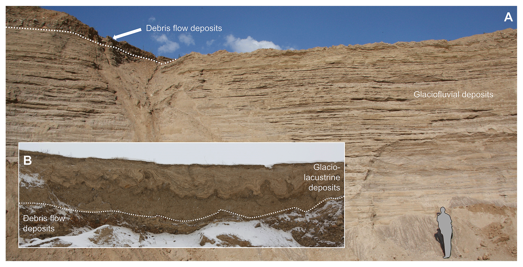
Figure 9Typical sediments of the Althüttendorf gravel pit: (a) glaciofluvial sands and gravels covered in part by diamictons deposited by debris flow events (photo: Christopher Lüthgens, 2016). (b) Glacio-lacustrine fines deposited on top of the irregular relief of the debris flow deposits showing post-depositional cryoturbation structures (photo: Christopher Lüthgens, 2009).
The outwash sediments of the Althüttendorf sandur and the Klosterbrücke outwash cone (about 10 km south-east of the Althüttendorf site), both being of the same morphostratigraphical relative age within the glaciofluvial drainage system of the region, were dated by means of optically stimulated luminescence (OSL) by Lüthgens et al. (2011). Mean ages based on multiple samples of 20.1±1.6 ka for Althüttendorf (initial phase of W2 sandur deposition) and of 19.4±2.4 ka for the Klosterbrücke (final phase of W2 sandur deposition) correlate nicely with the G-LGM.
In an abandoned clay pit (52.847582∘ N, 13.838394∘ E) in the Torún–Eberswalde ice-marginal valley near Macherslust (Fig. 10), north-east of the town of Eberswalde, banded clays and silts are exposed, which were deposited in a depression most likely formed by melting dead ice below ground (Marcinek and Schulz, 1995; Fig. 11). The 1–25 cm thick laminated silt layers and 2–10 mm thick clay layers dip to the west–north-west at an angle of ∼10∘, which was interpreted as an effect of continued melting of dead ice after deposition of the sediment succession (Schirrmeister, 2004). Because of a subaquatic slide that must have happened before the sediments were consolidated, part of the exposed section is intensely deformed. Although Pisarska-Jamroży (2013) uses the term “megavarves” to describe the sediments at Macherslust, the laminated sediments do not reflect annual layers (Schirrmeister, 2004). The succession of banded silts and clays is frequently intercalated with layers of fine sand, which is a clear sign that the glacio-lacustrine conditions were repeatedly interrupted by phases of streaming water conditions. According to Schirrmeister (2004) and Pisarska-Jamroży (2013), this indicates an influence of glacial meltwater originating from a distant ice margin. Lüthgens et al. (2011) dated the deposition of one of these sand layers to 14.7±1.0 ka. However, based on the available age constraints Krambach and Böse (2017) argue that the phase of deglaciation in the context of the Pomeranian ice advance (following a process-based interpretation of SED and OSL ages) occurred significantly earlier, and the deposits of Macherslust only reflect a phase of melting of buried dead ice and ongoing periglacial processes.

Figure 10DEM of the Macherslust area in the southern part of the Torún–Eberswalde ice-marginal valley. Waypoint 4: abandoned clay pit. Map projection: UTM 33∘ N; coordinate system: WGS 84; terrain model: Laserscan (GeoBasis-DE/LGB, 2020); hydrology: © OpenStreetMap contributors 2022. Distributed under the Open Data Commons Open Database License (ODbL) v1.0.
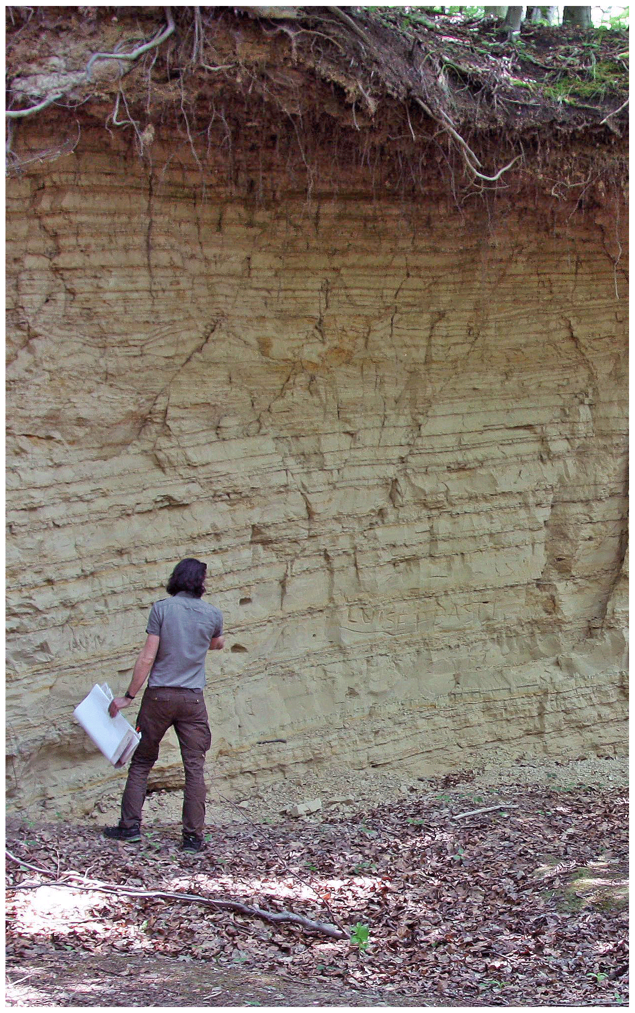
Figure 11Banded clays and silts exposed in the abandoned pit near Macherslust showing the dip of the sediments to the west–north-west and some deformation structures towards the top of the outcrop (photo: Christopher Lüthgens, 2016).
The route of the field trip now leaves the textbook glacial landscape of the Pomeranian ice-marginal position to the south (Fig. 1) and enters the landscape of the Barnim Plateau – an area traditionally ascribed to the Frankfurt ice-marginal position (W1F). However, recent research based on high-resolution analysis of a lidar DEM and subsequent fieldwork has shown that the area is actually lacking any geomorphological features like terminal-moraine-like landforms that could represent an ice-marginal position (Hardt et al., 2015). Instead, a succession of arcuate till ridges could be identified, with all ridges showing similar forms and dimensions, with a length varying between 1–1.5 km and a width of 10–15 km; they rise 6–10 m from their surrounding areas (Hardt et al., 2015; Fig. 12). The ridges are also identical with respect to their sedimentological composition, with the ridges all consisting of till deposited on top of glaciofluvial sands and meltwater deposits deposited in between the ridges (Hardt et al., 2015).
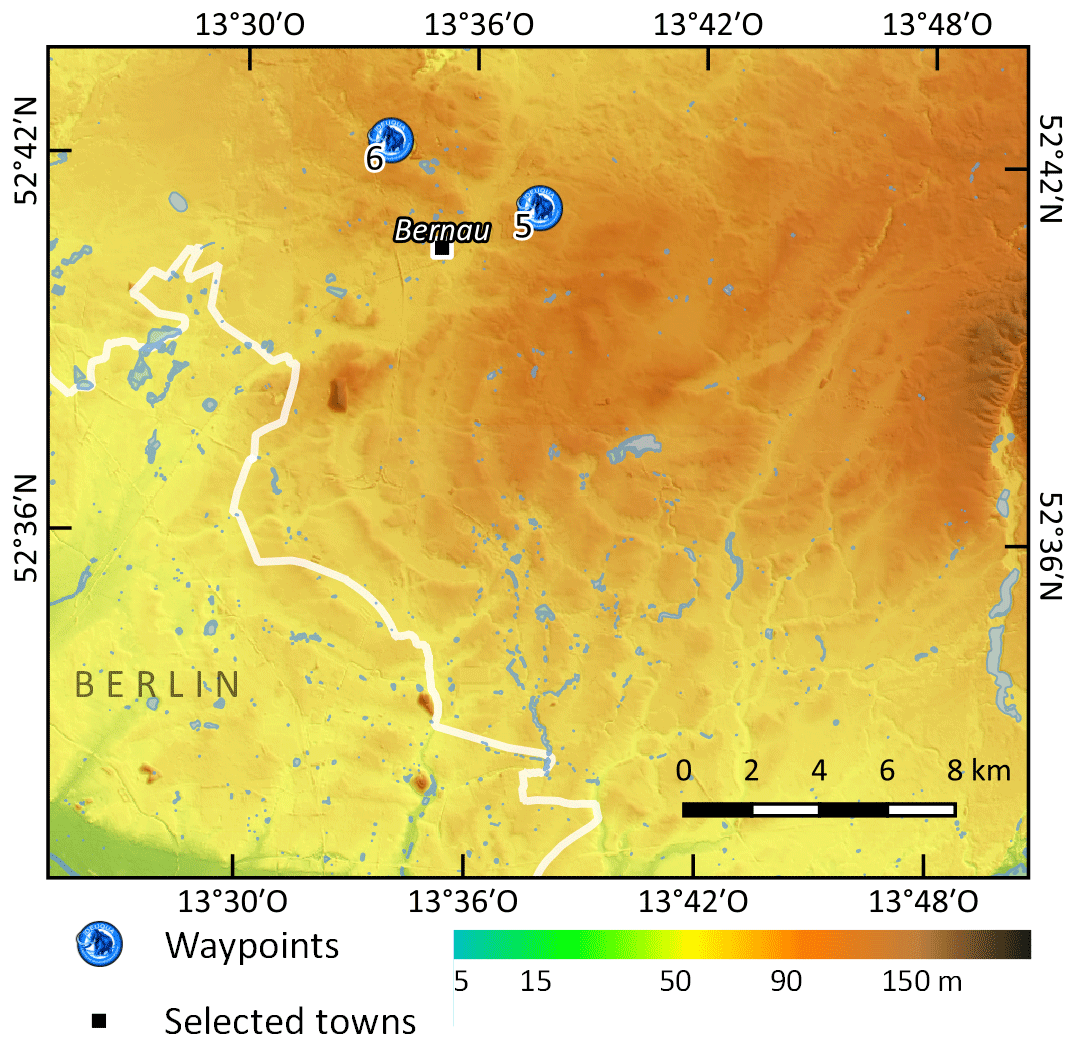
Figure 12DEM of the arcuate till ridges on the Barnim Plateau. This area was previously ascribed to the Frankfurt ice-marginal position (W1F). Please note that the till ridges are also visible within the Berlin city limits (white line). (5) Albertshof gravel pit, (6) Ladeburg gravel pit. Map projection: UTM 33∘ N; coordinate system: WGS 84; terrain model: Laserscan (GeoBasis-DE/LGB, 2020); hydrology: © OpenStreetMap contributors 2022. Distributed under the Open Data Commons Open Database License (ODbL) v1.0.
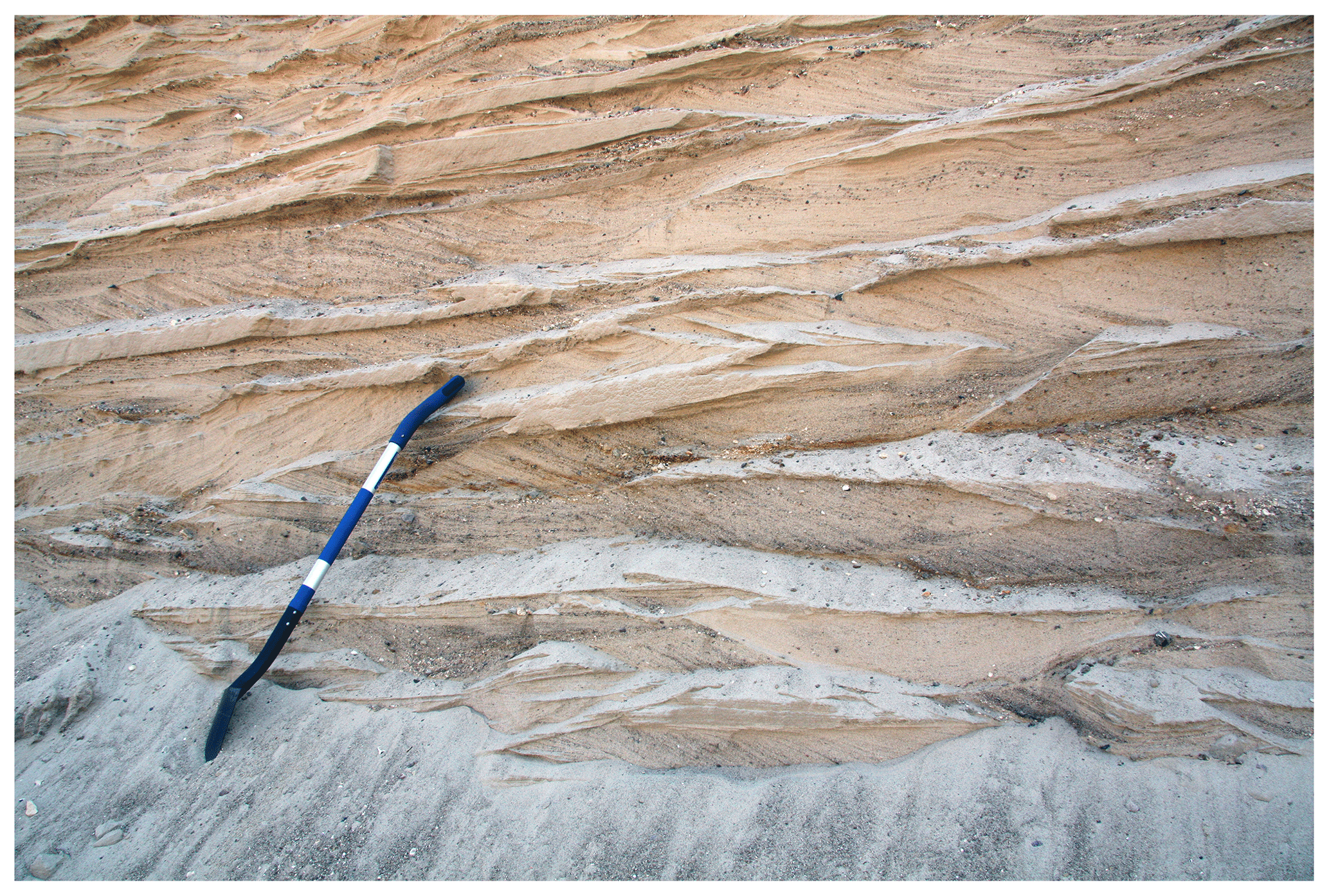
Figure 13Cross-bedded glaciofluvial sands and fine gravels exposed in the Albertshof gravel pit. Length of the shovel for scale approximately 1 m (photo: Christopher Lüthgens, 2016).
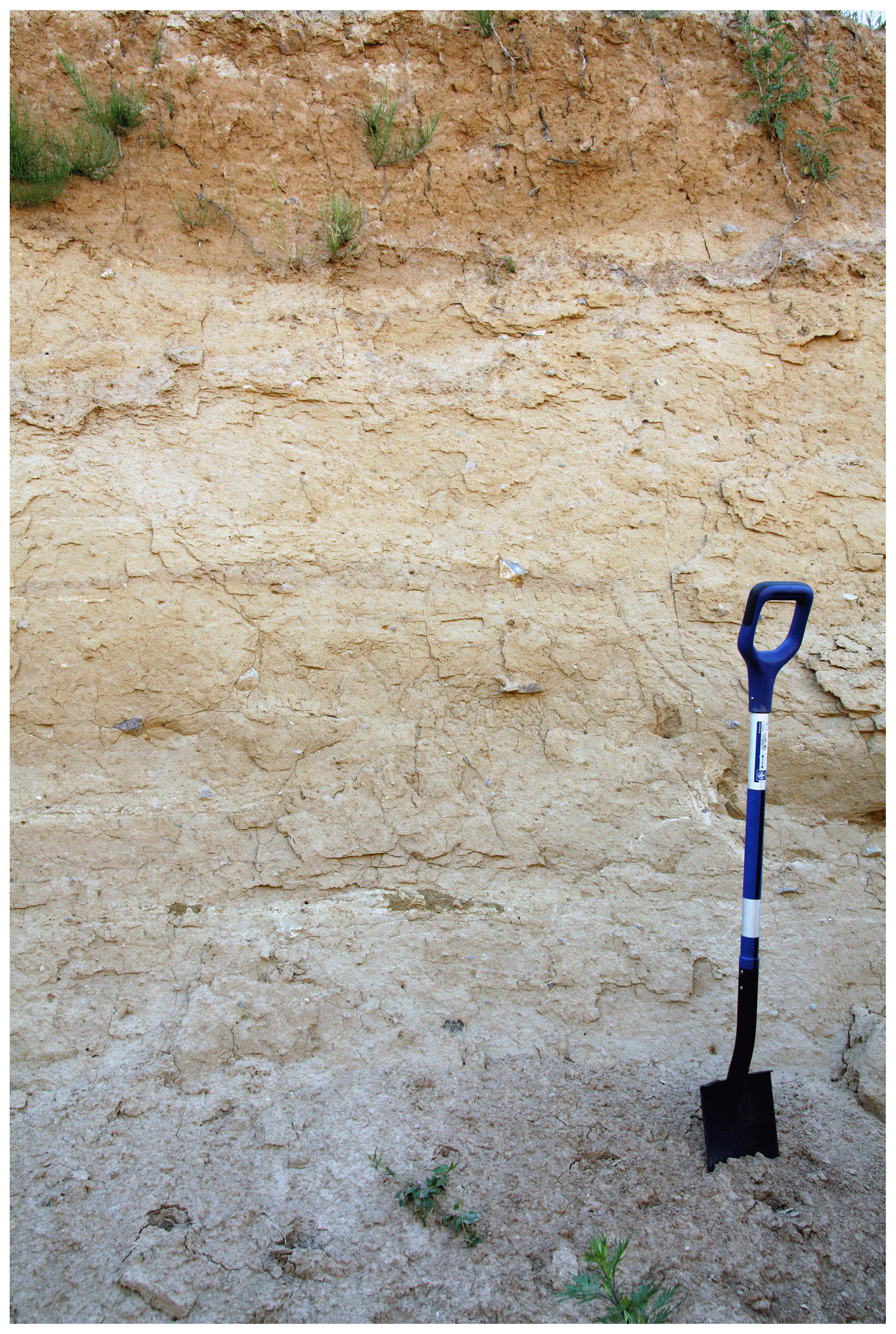
Figure 14Glacial till exposed in the Albertshof gravel pit. This till forms one of the arcuate ridges (compare Fig. 12) typical for the Barnim area (photo: Christopher Lüthgens, 2016).
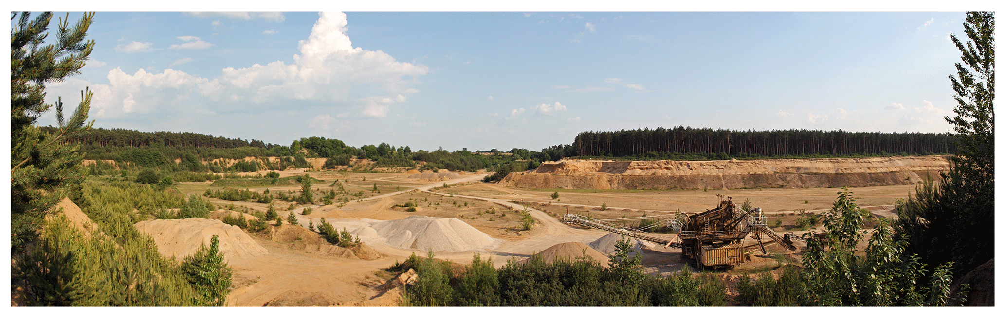
Figure 15Panoramic view from the northern edge of the Ladeburg gravel pit to the south, showing the size of the excavation and the outcrop wall that was investigated by Hardt et al. (2016). Panorama composed of 10 photos taken by Christopher Lüthgens (2016).
In the Albertshof gravel pit near Bernau (Fig. 12), the sediments of one of these ridges are exposed (52.687559∘ N, 13.627338∘ E). While the northern part of the pit consists of stratified sands and gravels (Fig. 13) topped by a nonstratified unit (Geschiebedecksand), the sediments of the ridge itself are accessible in the southern part of the pit. Here, a massive diamicton is exposed, containing 10 %–17 % of clay and silt and reaching a thickness of up to ∼4 m (Fig. 14). Stratified sands underlie this diamicton. The sedimentary pattern exposed here (glaciofluvial sands below the till ridges with meltwater sediment infills between the ridges) was also confirmed by means of electrical resistivity tomography (ERT) measurements in the vicinity of the gravel pit. These measurements covered a distance of about 700 m and allowed for interpretation of the sediments up to a depth of about 16 m below the landscape surface (Hardt et al., 2015).
The Ladeburg gravel pit is located about 5 km west of the previously described Albertshof gravel pit (Fig. 12) and is also situated on the fringe of one of the aforementioned lobate ridge structures (52.704494∘ N, 13.562466∘ E). This very ridge had been interpreted as representing the Frankfurt ice-marginal position W1F by previous authors (e.g. Hermsdorf et al., 1998). As described in Hardt et al. (2016), the sediment succession exposed in the upper part of the Ladeburg gravel pit, as well as ERT measurements in the vicinity of the pit, corroborates the findings from the Albertshof area with regard to the structural architecture of the arcuate ridges.
The excavation depth in the Ladeburg pit of up to almost 20 m below the landscape surface (Fig. 15) allows excellent access to a succession of sediments, which, at least in the upper part, had previously been ascribed to the W1F stage (Franz et al., 1970). The outcrop is dominated by layers of sands and gravel, which are intercalated by two massive matrix-supported diamictons. The upper diamicton has a thickness of about 1 m and occurs about 4 m below the surface. Towards the north of the pit, this diamicton thickens and transitions into and forms the ridge structure as described above. The lower diamicton has a thickness of about 2 m and occurs about 8 m below the surface. Directly below this diamicton, cryoturbation features within sand and gravel layers may indicate a former landscape surface. Hardt et al. (2016) provide a chronology for this sediment succession using OSL dating of the glaciofluvial sands. The lower diamicton is framed by luminescence ages between a minimum age of ka (underlying sands below the cryoturbation structures) and an age of 34.3±4.4 ka (overlying sands). The exact chronostratigraphic position of the lower till therefore remains unclear, but fine-gravel analyses conducted by Gärtner (1993) yielded a Saalian spectrum for the till. The upper diamicton, however, is framed by luminescence ages between 33.7±4.7 ka (underlying sands) and 25.1±3.7 ka (overlying sands), providing an excellent age estimate for the formation of the ridge, which most likely also applies to the formation of the other ridges in the Barnim area (Hardt et al., 2016). Taking all available geochronological data from the broader area into account (Lüthgens et al., 2010a, b, 2011, 2020; Lüthgens, 2011; Hardt et al., 2016), the formation of the ridges can be ascribed to the phase of ice decay and ice front retreat from the L-LGM position, the Brandenburg or W1B stage. Because there are no indications of a stable ice margin in the area, the ridges representing the W1B recessional phase replace the W1F ice-marginal position in the Barnim area.
These new results from the sites visited during this field trip clearly show the importance of a process-based interpretation of numerical ages and call for a time-based reconstruction of ice sheet extents, as opposed to the traditional morphostratigraphical approach, which inevitably results in time-transgressive reconstructions and models. Only by using a time-based reconstruction can the available numerical ages (summarised for the Brandenburg area in Fig. 16) serve as vital tools for the reconstruction of ice sheet dynamics. Following this approach, Lüthgens et al. (2020) recently proposed a new conceptual model for the reconstruction of ice dynamics in the south-western sector of the SIS in MIS 2. The new insights gained in the area visited during this field trip have significantly contributed to opening new doors for the interpretation of the dynamics in the south-western sector of the SIS with multiple new and fascinating scenarios now within the realm of possibility, as proposed by Lüthgens et al. (2020).
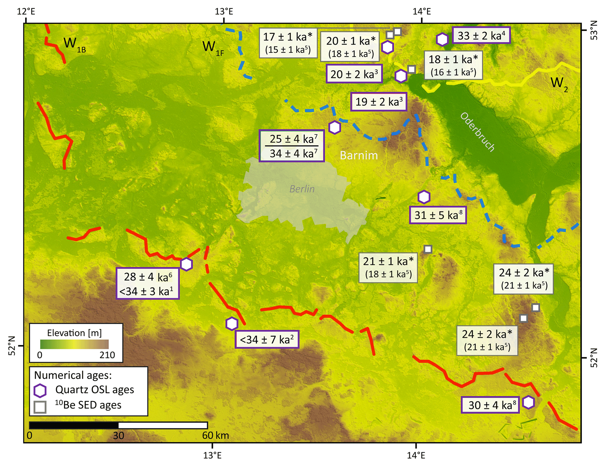
Figure 16Summary of OSL and SED ages: 1 Lüthgens et al. (2010a), 2 Lüthgens et al. (2010b), 3 Lüthgens et al. (2011), 4 Brauer et al. (2005), 5 SED ages (asterisks indicate the recalculated ages from Hardt and Böse, 2016, using CRONUS online (Balco et al., 2008) and the alternative calibration dataset by Heyman 2014; original ages provided in brackets), 6 Lüthgens (2011), 7 Hardt et al. (2016), 8 Lüthgens et al. (2020). Base map derived from hillshaded SRTM data. Figure modified from Hardt (2017).
All cited datasets can be accessed publicly via the referenced original publications. In addition, Table 1 in Lüthgens et al. (2020) provides a compilation of most of the cited datasets.
CL and JH have planned the field trip route. CL and JH conducted the literature research and composed the maps. CL prepared the original draft, which was reviewed and edited by JH.
The contact author has declared that none of the authors has any competing interests.
Publisher’s note: Copernicus Publications remains neutral with regard to jurisdictional claims in published maps and institutional affiliations.
The authors want to thank Margot Böse for providing a photograph of the Sperlingsherberge rock quarry. The authors highly appreciate the commitment of the editors of this DEUQUA Special Publications field guide, Achim Brauer, Markus Schwab, and Henrik Rother.
Balco, G., Stone, J. O., Lifton, N. A., and Dunai, T. J.: A complete and easily accessible means of calculating surface exposure ages or erosion rates from 10Be and 26Al measurements, Quat. Geochronol., 3, 174–195, https://doi.org/10.1016/j.quageo.2007.12.001, 2008.
Börner, A.: Das Eberswalder Urstromtal: Untersuchungen zur pleistozänen Landschaftsgenese zwischen Niederem Oderbruch und Werbellinseerinne (Nordost-Brandenburg), Schriftenreihe für Geowissenschaften, 17, 118, ISBN 3-937040-20-X, 2007.
Brauer, A., Tempelhoff, K., and Murray, A. S.: OSL Dating of Fine-Grained Sand Deposits and its Implications for Glacial Stratigraphy and Landscape Evolution: Research Results from Stolzenhagen, Northeastern Brandenburg, Erde, 136, 15–35, 2005.
Brose, F.: Weichselglaziale Rückzugsstaffeln im Hinterland der Eisrandlage des Pommerschen Stadiums südlich von Angermünde, Wissenschaftliche Zeitschrift der Ernst-Moritz-Arndt-Universität Greifswald, Mathematisch-naturwissenschaftlische Reihe, 27, 17–19, 1978.
Ehlers, J. and Gibbard, P. L.: Preface, in: Developments in Quaternary Sciences, edited by: Ehlers, J. and Gibbard, P. L., Vol. 2, Part 1, Elsevier, VII–VIII, https://doi.org/10.1016/S1571-0866(04)80050-2, 2004.
Franz, H.-J., Schneider, R., and Scholz, E.: Geomorphologische Übersichtskarte Berlin-Potsdam, edited by: Gellert, J. F. and Scholz, E., Haack, Gotha, 1970.
Gärtner, P.: Beiträge zur Landschaftsgeschichte des westlichen Barnim, Fachbereich Geographie der Humboldt-Universität zu Berlin, Berliner Geographische Arbeiten, 77, 109, 1993.
Gärtner, P., Behrendt, L., Bussemer, S., Marcinek, J., Markuse, G., and Schlaak, N.: Quartärmorphologisches Nord-Südprofil durch Brandenburg, Berichte zur deutschen Landeskunde, 69, 229–262, 1995.
GeoBasis-DE/LGB: Digital Terrain Model 1 of Brandenburg, dl-de/by-2-0, https://data.geobasis-bb.de/geobasis/daten/dgm/ (last access: 28 July 2022), 2020.
Hardt, J.: Weichselian phases and ice dynamics of the Scandinavian Ice Sheet in Northeast Germany – A reassessment based on geochronological and geomorphological investigations in Brandenburg, Department of Geosciences, Freie Universität Berlin, Berlin, https://doi.org/10.17169/refubium-4585, 2017.
Hardt, J. and Böse, M.: The timing of the Weichselian Pomeranian ice marginal position south of the Baltic Sea: A critical review of morphological and geochronological results, Quatern. Int., 478, 51–58, https://doi.org/10.1016/j.quaint.2016.07.044, 2016.
Hardt, J., Hebenstreit, R., Lüthgens, C., and Böse, M.: High-resolution mapping of ice-marginal landforms in the Barnim region, northeast Germany, Geomorphology, 250, 41–52, https://doi.org/10.1016/j.geomorph.2015.07.045, 2015.
Hardt, J., Lüthgens, C., Hebenstreit, R., and Böse, M.: Geochronological (OSL) and geomorphological investigations at the presumed Frankfurt ice marginal position in northeast Germany, Quaternary Sci. Rev., 154, 85–99, https://doi.org/10.1016/j.quascirev.2016.10.015, 2016.
Hardt, J., Norden, B., Bauer, K., Toelle, O., and Krambach, J.: Surface cracks – Geomorphological indicators for late Quaternary halotectonic movements in Northern Germany, Earth Surf. Proc. Land., 46, 2963–2983, https://doi.org/10.1002/esp.5226, 2021.
Heine, K., Reuther, A. U., Thieke, H. U., Schulz, R., Schlaak, N., and Kubik, P. W.: Timing of Weichselian ice marginal positions in Brandenburg (northeastern Germany) using cosmogenic in situ 10Be, Z. Geomorphol., 53, 433–454, https://doi.org/10.1127/0372-8854/2009/0053-0433, 2009.
Hermsdorf, N., Lippstreu, L., Sonntag, A., Beer, H., and Stackebrandt, W.: Geologische Übersichtskarte 1: 200,000, CC 3942 Berlin, Bundesanstalt für Geowissenschaften und Rohstoffe, Hannover, 1998.
Heyman, J.: Paleoglaciation of the Tibetan Plateau and surrounding mountains based on exposure ages and ELA depression estimates, Quaternary Sci. Rev., 91, 30–41, https://doi.org/10.1016/j.quascirev.2014.03.018, 2014.
Hultzsch, A.: Althüttendorf/Groß Ziethen – Blockpackung und Sander, in: Führer zur Geologie von Berlin und Brandenburg: Bad Freienwalde-Parsteiner See, 2nd edn., edited by: Schroeder, J. H., Geowissenschaftler in Berlin und Brandenburg e.V., 116–127, ISBN 978-3-928651-03-5, 1994.
Kozarski, S.: Die glazialen Abflußverhältnisse im westlichen Teil des Notéc-Warta Urstromtales, Wissenschaftliche Zeitschrift der Ernst-Moritz-Arndt-Universität Greifswald, Mathematisch-naturwissenschaftliche Reihe, 15, 63–72, 1966.
Krambach, M. and Böse, M.: The morphological units between the end moraines of the Pomeranian phase and the Eberswalde ice-marginal valley (Urstromtal), Germany – a critical examination by means of a high-resolution DEM, E&G Quaternary Sci. J., 66, 44–56, https://doi.org/10.3285/eg.66.1.04, 2017.
Liedtke, H.: Beiträge zur geomorphologischen Entwicklung des Thorn-Eberswalder Urstromtales zwischen Oder und Havel, Wissenschaftliche Zeitschrift der Humboldt-Universität Berlin, Mathematisch-naturwissenschaftliche Reihe 6, 3–49, 1956.
Liedtke, H.: Die nordischen Vereisungen in Mitteleuropa, Forschungen zur deutschen Landeskunde, 2nd edn., 204, 307, ISBN 3881430202, 1981.
Lüthgens, C.: The age of Weichselian main ice marginal positions in north-eastern Germany inferred from Optically Stimulated Luminescence (OSL) dating, PhD thesis, Department of Earth Sciences, Freie Universität Berlin, https://doi.org/10.17169/refubium-8554, 2011.
Lüthgens, C. and Böse, M.: Chronology of Weichselian main ice marginal positions in north-eastern Germany, E&G Quaternary Sci. J., 60, 17, https://doi.org/10.3285/eg.60.2-3.02, 2011.
Lüthgens, C. and Böse, M.: From morphostratigraphy to geochronology – on the dating of ice marginal positions, Quaternary Sci. Rev., 44, 26–36, https://doi.org/10.1016/j.quascirev.2010.10.009, 2012.
Lüthgens, C., Böse, M., and Krbetschek, M.: On the age of the young morainic morphology in the area ascribed to the maximum extent of the Weichselian glaciation in north-eastern Germany, Quatern. Int., 222, 72–79, https://doi.org/10.1016/j.quaint.2009.06.028, 2010a.
Lüthgens, C., Krbetschek, M., Böse, M., and Fuchs, M. C.: Optically stimulated luminescence dating of fluvioglacial (sandur) sediments from north-eastern Germany, Quat. Geochronol., 5, 237–243, https://doi.org/10.1016/j.quageo.2009.06.007, 2010b.
Lüthgens, C., Böse, M., and Preusser, F.: Age of the Pomeranian ice-marginal position in northeastern Germany determined by Optically Stimulated Luminescence (OSL) dating of glaciofluvial sediments, Boreas, 40, 598–615, https://doi.org/10.1111/j.1502-3885.2011.00211.x, 2011.
Lüthgens, C., Hardt, J., and Böse, M.: Proposing a new conceptual model for the reconstruction of ice dynamics in the SW sector of the Scandinavian Ice Sheet (SIS) based on the reinterpretation of published data and new evidence from optically stimulated luminescence (OSL) dating, E&G Quaternary Sci. J., 69, 201–223, https://doi.org/10.5194/egqsj-69-201-2020, 2020.
Marcinek, J. and Schulz, I.: Im klassischen Gebiet der norddeutschen Eiszeitforschung – Im Raum der Pommerschen Eisrandlage um Chorin und der Finow, Berliner Geographische Studien, 40, 197–213, 1995.
OpenStreetMap: OpenStreetMap contributors, https://www.openstreetmap.org, last access: 28 July 2022.
Pisarska-Jamroży, M.: Transitional deposits between the end moraine and outwash plain in the Pomeranian glaciomarginal zone of NW Poland: a missing component of ice-contact sedimentary models, Boreas, 35, 126–141, https://doi.org/10.1111/j.1502-3885.2006.tb01117.x, 2006.
Pisarska-Jamroży, M.: Varves and megavarves in the Eberswalde Valley (NE Germany) – A key for the interpretation of glaciolimnic processes, Sediment. Geol., 291, 84–96, https://doi.org/10.1016/j.sedgeo.2013.03.018, 2013.
Rinterknecht, V., Braucher, R., Böse, M., Bourlès, D., and Mercier, J. L.: Late Quaternary ice sheet extents in northeastern Germany inferred from surface exposure dating, Quaternary Sci. Rev., 44, 89–95, https://doi.org/10.1016/j.quascirev.2010.07.026, 2012.
Rinterknecht, V. R., Clark, P. U., Raisbeck, G. M., Yiou, F., Bitinas, A., Brook, E. J., Marks, L., Zelcs, V., Lunkka, J. P., Pavlovskaya, I. E., Piotrowski, J. A., and Raukas, A.: The last deglaciation of the southeastern sector of the Scandinavian Ice Sheet, Science, 311, 1449–1452, https://doi.org/10.1126/science.1120702, 2006.
Schirrmeister, L.: Macherslust: Glazilakustrine Ablagerungen, in: Führer zur Geologie von Berlin und Brandenburg, 5, Nordwestlicher Barnim-Eberswalder Urstromtal-Naturpark Barnim, edited by: Schroeder, J. H., Geowissenschaftler in Berlin und Brandenburg e.V., 236–245, ISBN 978-3-928651-06-6, 2004.
- How to cite
- Abstract
- Introduction
- Kleiner Rummelsberg (geomorphological overview)
- Ihlowberge–Sperlingsherberge (terminal moraines of the Pomeranian stage)
- Althüttendorf gravel pit (ice-proximal sandur sediments)
- Macherslust clay pit (banded silts and clays)
- Albertshof gravel pit (the vanishing of an ice-marginal position – part 1)
- Ladeburg gravel pit (the vanishing of an ice-marginal position – part 2)
- Summary
- Data availability
- Author contributions
- Competing interests
- Disclaimer
- Acknowledgements
- References