 | 15 Sep 2022
To the southern margin of the (last) northern glaciation – a field trip through the young moraine area south-east of Berlin
Olaf Juschus
Mirosław Błaszkiewicz
Lars Böttner
Juschus, O., Błaszkiewicz, M., and Böttner, L.: To the southern margin of the (last) northern glaciation – a field trip through the young moraine area south-east of Berlin, DEUQUA Spec. Pub., 4, 19–28, https://doi.org/10.5194/deuquasp-4-19-2022, 2022.
The young moraine area to the south-east of Berlin was repeatedly overrun and covered by Scandinavian ice sheets (SISs). The last glaciation took place during the Last Glacial Maximum (LGM), when the last/most recent SIS reached its furthest southern extent. An incompletely formed chain of terminal moraines marks the Brandenburg ice stage. The most recent glacier had its greatest environmental impact due to the large quantities of released meltwaters. Many subglacial channels, massive proglacial sands and huge meltwater streamways (Urstromtäler) were formed at that time. During the Holocene, the landscape was finally shaped mainly by the rivers Dahme and Spree.
- Article
(9917 KB) - Full-text XML
- BibTeX
- EndNote


Dedicated to Norbert Hermsdorf (1961–2019).
The field trip will take us to interesting sites of Quaternary geology and geomorphology to the south-east of Berlin. The stops will cover a wide range of different topics connected not only with the waxing and waning of the Scandinavian ice sheets but also with the history of the post-glacial landscape and human impact. During the field trip, we will visit outcrops with Quaternary sediments from different ice advances and morphological sites like the southernmost Weichselian terminal moraines of the Brandenburg phase (WB) as well as late glacial palaeochannels of the river Dahme (Fig. 1).
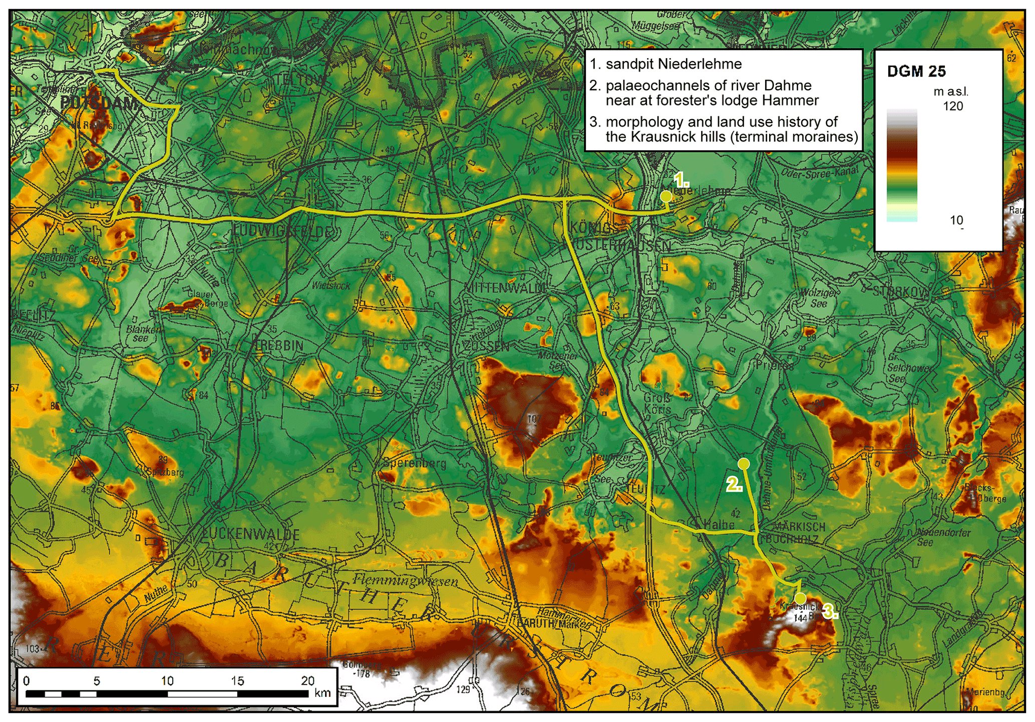
Figure 1Overview, route and stops of field trip “To the southern margin of the (last) northern glaciation” (base map: Landesvermessung und Geobasisinformation Brandenburg). The raised, island-like Quaternary plateaus are visible within the elongated meltwater streamways. For distribution of morainic plateaus and meltwater streamways see also Fig. 4.
1.1 Historical overview
The geological exploration of this area close to Berlin began immediately after the implementation of glacial theory in Germany. Beginning in the 1880s, most sheets of the 1:25 000-scale geological map were being mapped by the geologists of the Prussian Geological Survey (in the late 19th century under the leadership of Berendt and Wahnschaffe, in the early 20th century under the leadership of Fliegel and Keilhack). Thus, the general composition of the Quaternary of the region was already known at the beginning of the 20th century. During the 1950s Genieser (1957) published on the Mid-Pleistocene gravels of the so-called Berlin Elbe River. After 1990 the investigations of Hermsdorf (1995) and Juschus (2001) are worth mentioning. Hermsdorf (1995) gave a summary of the general geological settings of the Quaternary in the area which still corresponds to the current state of knowledge. Juschus (2001) was focused on landscape development during the Weichselian glaciation and the Holocene. A modern, 1:100 000-scale geological map of this region was published by Hermsdorf (2007).
Geomorphological investigations in this region have focused mainly on the course of the terminal moraines of the Brandenburg phase and the development of the Baruth ice-marginal valley. Following initial approaches by Berendt (1880), Lembke (1936) described the height relationships of the main valley and the adjacent run-off paths. Marcinek (1961) and Juschus (2001) added further findings, especially on the phased development of the Baruth ice-marginal valley. While Marcinek (1961) described two run-off phases, Juschus (2001) extended the model to up to four phases, to which different terrace levels are assigned. All four phases followed in a short time frame the maximum advance of the Weichselian ice sheet.
The time frame of the last ice advance was recently dated by the investigations of Lüthgens et al. (2010, among others). Using the OSL method, they determined an age (maximum age) of 34.1±3.0 kyr. Litt et al. (2007) give an age estimate of between 20 and 24 kyr BP (based on extrapolations of calibrated 14C ages in northern Germany and northern Poland).
1.2 General geological settings
The Quaternary sequence in the region starts with Elsterian deposits (Fig. 2). Older Quaternary sediments have not been described so far. The thickness of the Elsterian sediments varies within a wide range and is mainly determined by the occurrence of deep subglacial channels of Elsterian age. The base of the Quaternary deposits lies at between −75 and −500 m inside the channels and at −25 to −40 m outside them. Locally, the top of autochthonous Miocene sediments lies at around sea level. The Elsterian sediments are mainly preserved as channel infill. Outside the channels, they are relatively weak or completely absent. Usually, the Elsterian sediments consist of fine- and medium-grained sands, silty–clayey basin deposits, and till. Allochthonous packages of Neogene sediments are relatively common. The Elsterian stratigraphic sequence is characterised by relatively strong deformation features, mainly induced by gravitational mass movements and, more commonly, glaciotectonics.
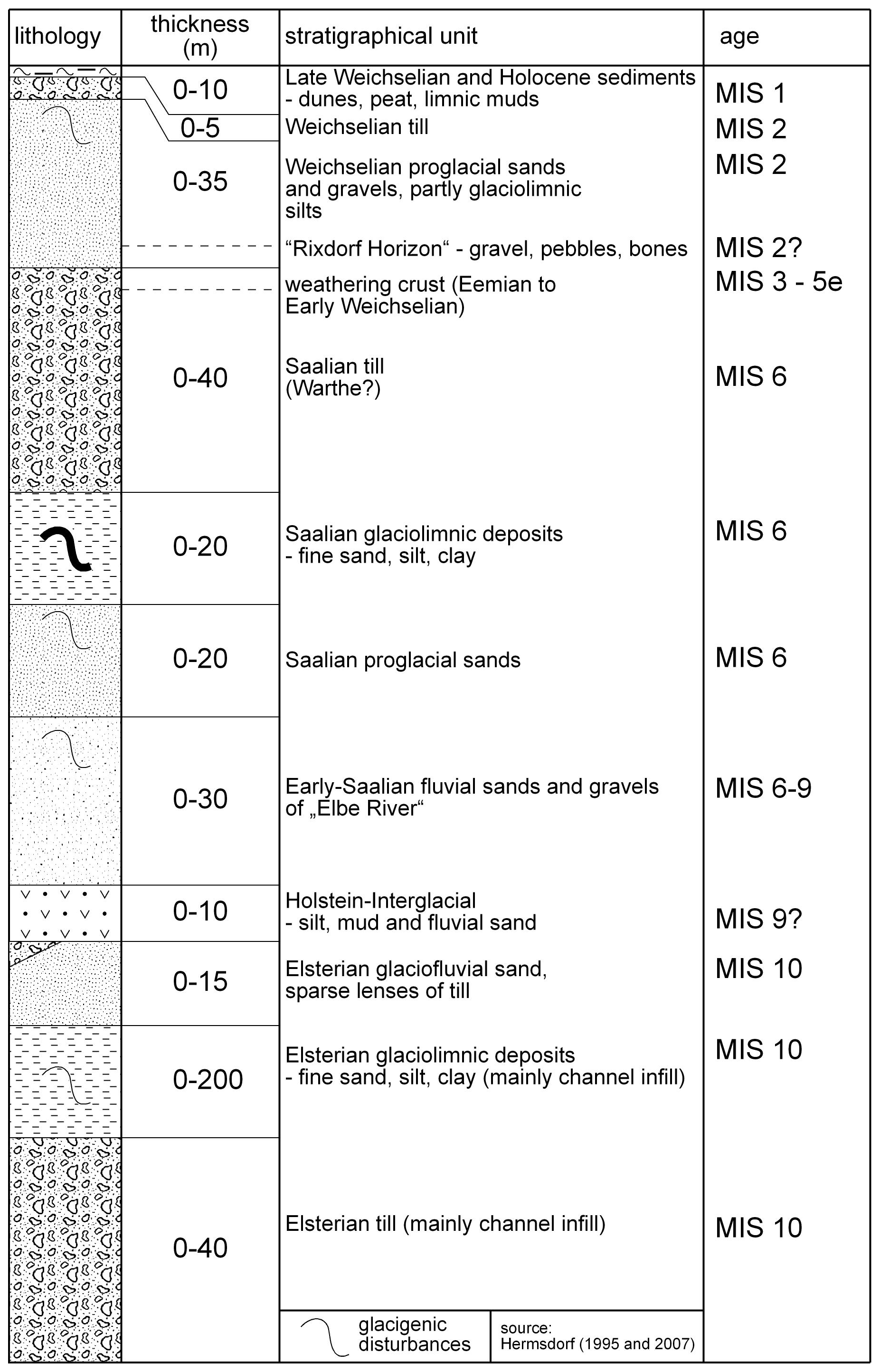
The subsequent Holsteinian interglacial is characterised by its large horizontal and vertical distribution of commonly sandy to gravelly fluvial sediments. In between, several layers of silts and muds can be found. The fluvial activity continued after the end of the Holsteinian until the Saalian ice advances. These sediments were connected by Genieser (1957) to a precursor of the river Elbe.
Saalian sediments are composed of thick, partly gravelly proglacial sands, which are overlain by only one Saalian till. The complete absence of a second Saalian till still causes problems in correlating Saalian deposits with adjacent regions, where two till layers are common. Both a primary absence and a subsequent removal are conceivable. Based on indicator pebble analysis, there is some evidence that the occurring till was settled during the younger (Warthe) phase of Saalian glaciation. Strong glaciotectonic features are very common within Saalian deposits.
The surface of the Saalian sediments shows extensive weathering phenomena, which are attributed to the Eemian interglacial and the subsequent Early Weichselian period. In contrast to Holsteinian sediments, Eemian deposits are restricted to a number of small-scale basins.
The sediments of the Weichselian glaciation are mainly built up of sandy–silty or sandy–gravelly proglacial deposits, which often reach thicknesses of 10 to 15 m. With an average thickness of less than 3 m, the sandy Weichselian till is comparably thin and patchy.
Thus, the most recent glacial advance had its greatest environmental impact due to its large quantities of released meltwaters. Many subglacial channels, massive proglacial sands and huge meltwater streamways (Urstromtäler) were formed at that time. The streamways cover more than half of the area. Thus, the young moraine area to the south and south-east of Berlin is a patchwork of elongated meltwater streamways with raised island-like quaternary plateaus.
In addition to late glacial dune sands, Holocene muds and peats occur mainly as infills of Weichselian glacial channels.
The sandpit near Niederlehme contains a succession of Quaternary deposits typical of the young moraine area to the south-east of Berlin. Due to its vicinity to Berlin, the profiles of the pit have been repeatedly investigated (e.g. Wahnschaffe, 1910; Cepek, 1986; Böse, 1997; Hermsdorf, 2000; Juschus and Błaszkiewicz, 2002).
At the bottom of the outcrop, deposits of Saalian age composed of heterogeneous material are found. Till is most frequent, but lenses of sand and silt are common as well. The till mainly consists of silt. As is typical of lower till, the boulders mainly originate from the ground of the Baltic Sea (north-eastern direction).
These older deposits are overlain by comparably coarse-grained glaciofluvial material, the so-called “Rixdorf Horizon” (Figs. 2, 3). These gravels contain bones of huge mammals (mammoths, woolly rhinos, etc.) as well as other remains of the old, proglacial landscape such as weathered rocks and ventifacts. The Rixdorf Horizon was formed by the initial Weichselian meltwaters, running from the south-east to north-west.
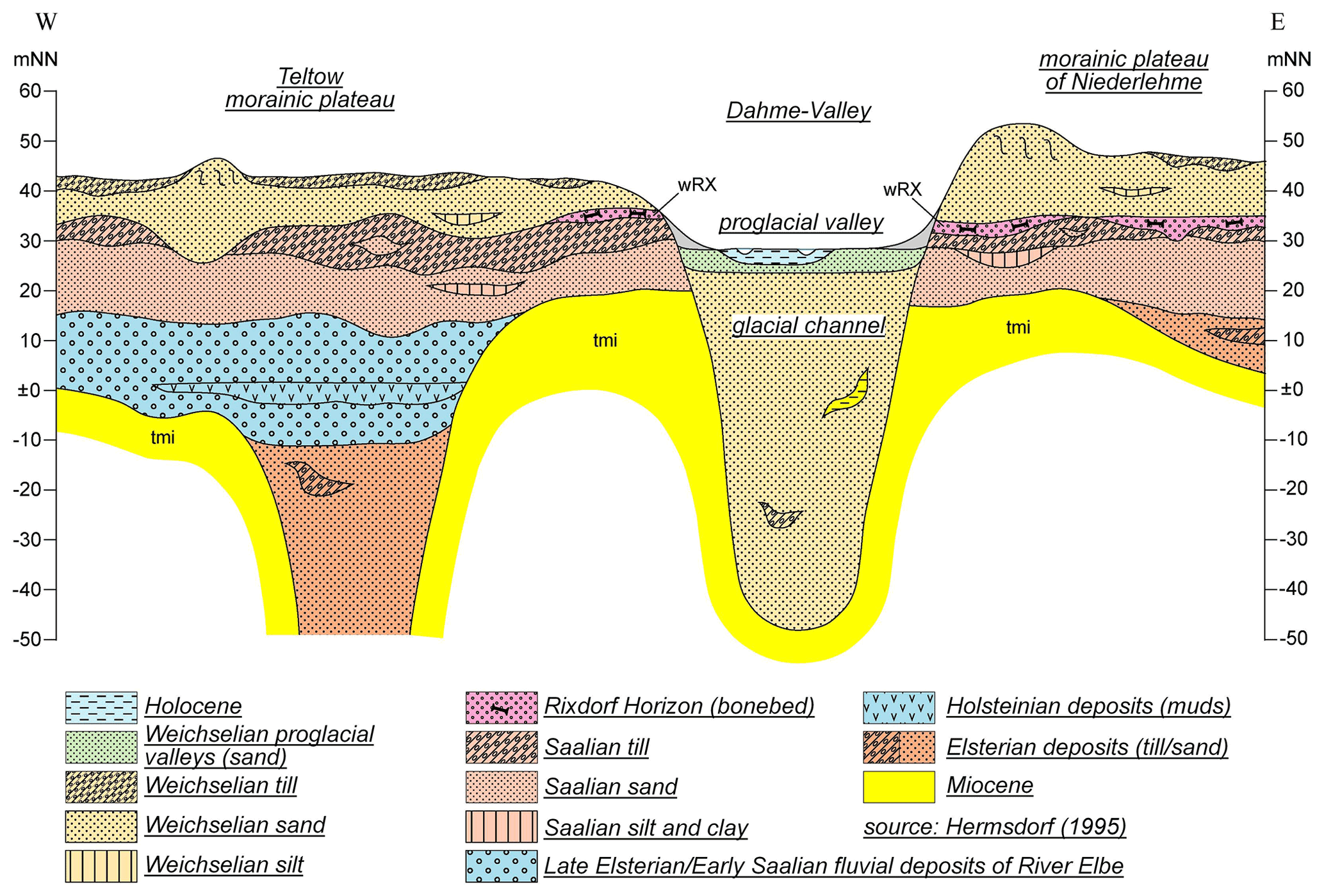
On top of the Rixdorf Horizon, there are thick proglacial sands with sparse lenses of silt or coarser material. These sands are the main target of the sand excavation. Excluding some periglacial deposits, the top of the sediment succession is formed by a thin and patchy till of Weichselian age. The pebbles inside this till originate mainly from eastern Sweden (northern direction). In contrast to the older Saalian till, the Weichselian till is dominated by a sandy matrix.
3.1 Introduction
The small town of Märkisch Buchholz is situated inside a huge basin area, mainly formed by meltwater streamways (Fig. 4). The valley-like character is somewhat blurred by the large extent of this basin (approx. 15 km in diameter). It has already been created as a deep-lying area during the Saalian glacial period. Decametre-thick glaciolimnic sediments were deposited in an ice-dammed lake, while the surrounding plateaus are dominantly built up of Saalian morainic deposits (till and glaciofluvial sand). This older relief was only partially reshaped by the relatively thin ice sheet of the Weichselian glaciation.

Figure 4The system of meltwater streamways between the Baruth ice-marginal valley (Phase 1 in the south) and the Berlin ice-marginal valley in the north (Phase 4 in the north). Dunes as well as the Dahme channel have been drawn in.
3.2 Weichselian glacial
During the maximum advance of the last Scandinavian ice sheet, the low-lying area was completely covered by the glacier. The maximum extent reached a few kilometres south of the basin along a line, marked by the Krausnick hills, the basin of Oderin and hills to the south of Teupitz. The glacier ploughed up a contour line that attracted the subglacial drainage. Thus, the Dahme channel was cut into the underlying sediments of Weichselian and Saalian age. Later the channel became filled with gyttja and peat (Fig. 5). Subglacial channels are a common feature in the young moraine area to the south of Berlin. A few kilometres to the west, there is the neighbouring channel of the Teupitz lakes.
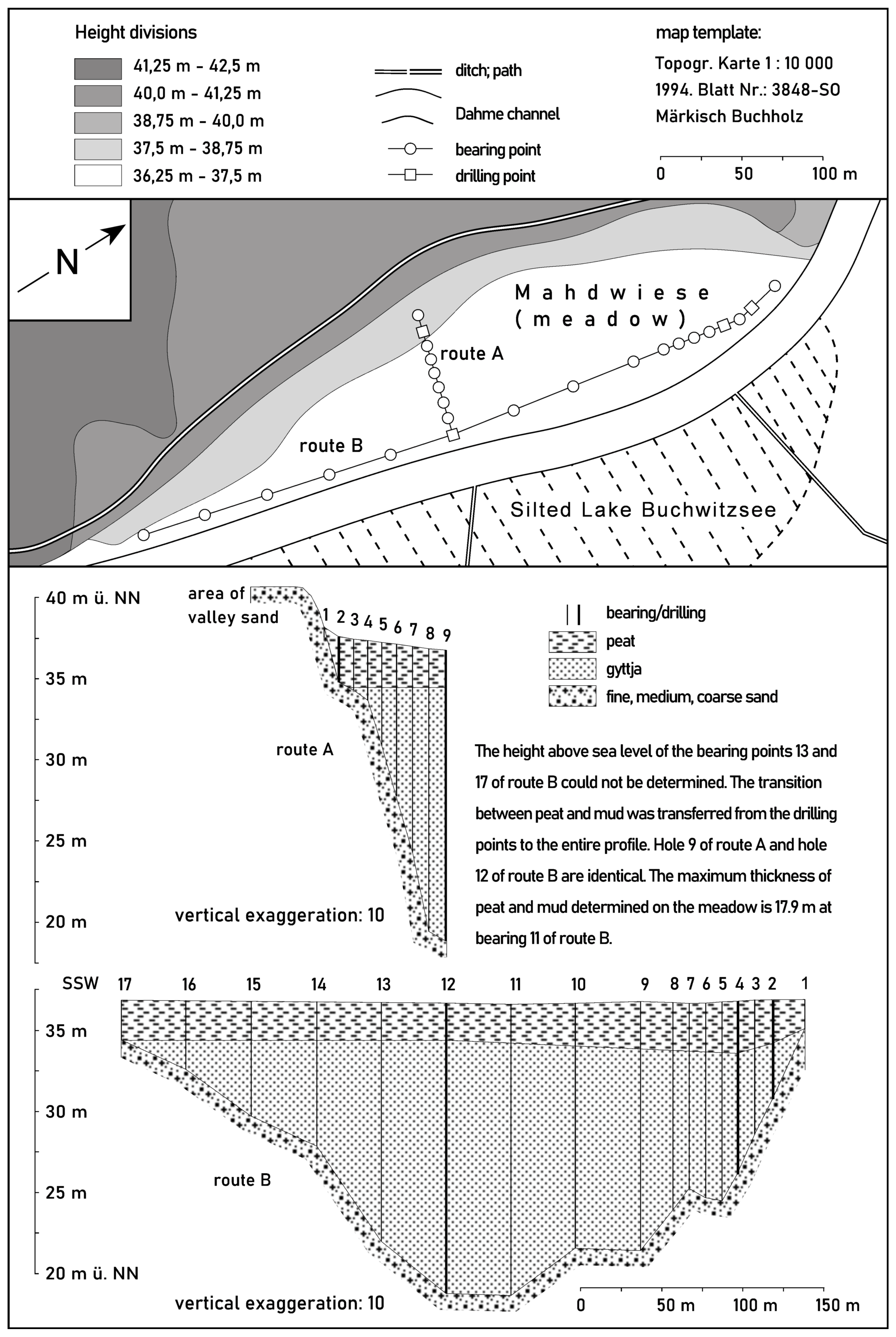
Figure 5Geological profiles through the silted lake Buchwitzsee. It is situated in the southern part of the Dahme channel.
Further south, in the Oderin basin, the subglacial Dahme channel reached the Baruth ice-marginal valley. There, the meltwater was discharged via a glacier gate to the subaerial valley. However, traces of subglacial drainage are not well-preserved in the Oderin basin.
With the beginning of the melting of the ice sheet, the subglacial channels could have been filled in by meltwater sediments and blocks of dead ice. The contiguous body of ice disintegrated into individual blocks that gradually melted in the following. The Dahme channel, as well as the channel of the Teupitz lakes, was deactivated and sealed with dead ice.
3.3 Weichselian glaciofluvial phase
With the ongoing progress of the melting of the ice sheet, the low-lying area of Märkisch Buchholz was formed by subaerial meltwater streams. Subsequently, the Baruth ice-marginal valley fell dry. The meltwater stream had several outlets to flow from the basin of Märkisch Buchholz first to the west and later to the north (Fig. 4). During the subsequent phases, different terrace levels were formed at between 45 and 37 m a.s.l. The edges of the surrounding morainic plateaus were incised by the meltwaters.
The dead ice that sealed the Dahme channel as well as the channel of the Teupitz lakes was covered by the sediment load of the meltwater and thus preserved. Moreover, some blocks of dead ice were also preserved outside the channels. In the post-glaciofluvial phase, this conserved dead ice, which was a few metres thick only, thawed out to form shallow basins, regionally known as Luche.
The melting of the Weichselian ice sheet stopped to the north of Berlin during the Frankfurt phase. This was accompanied by the formation of the Berlin ice-marginal valley. As a result, the main outflow of the meltwater, which had previously flown through the Baruth ice-marginal valley and the basin of Märkisch Buchholz, was increasingly rerouted into the Berlin valley.
3.4 The periglacial and late glacial phase
After the meltwater flow had dried up, the basin of Märkisch Buchholz appeared as a low-elevation area with very low relief energy. It was completely covered by glaciofluvial sands. However, the area remained exposed to periglacial processes for several thousand years. Under the influence of westerly winds, large fields of dunes were formed, especially in the eastern part of the basin (Fig. 4). In addition to irregularly shaped dunes, parabolic dunes were formed. Some of the elongated dunes crossed the Dahme channel, which at that time was still sealed with dead ice.
In periglacial times, a precursor of the river Dahme (called the “Palaeo-Dahme”) left the Baruth ice-marginal valley and flowed through the Oderin basin to the north. It hit the basin of Märkisch Buchholz from the south. At this time, the dead-ice infill of the Dahme channel gradually began to thaw. The river entered the resulting shallow depression and followed its course into the basin of Märkisch Buchholz. At Klein Hammer, the Palaeo-Dahme was dammed in front of a dune ridge that was blown onto the channel. At the so-called “Brennesselwiese”, an overflow to the lowest terrace level of the meltwater streamway exists (Fig. 6). On this terrace level the river Palaeo-Dahme flowed to the north-west. Within this process, the Stintgraben lowland was cut into the surface of the basin of Märkisch Buchholz. A system of meandering palaeochannels was formed. Some of the mentioned Luche basins were fluvially reshaped by the river as well. Close to Klein Köris, the river Palaeo-Dahme flowed into the basin of the Klein Köriser See, which is part of the channel of the Teupitz lakes. To the north, the river used the channel to reach the Berlin ice-marginal valley.
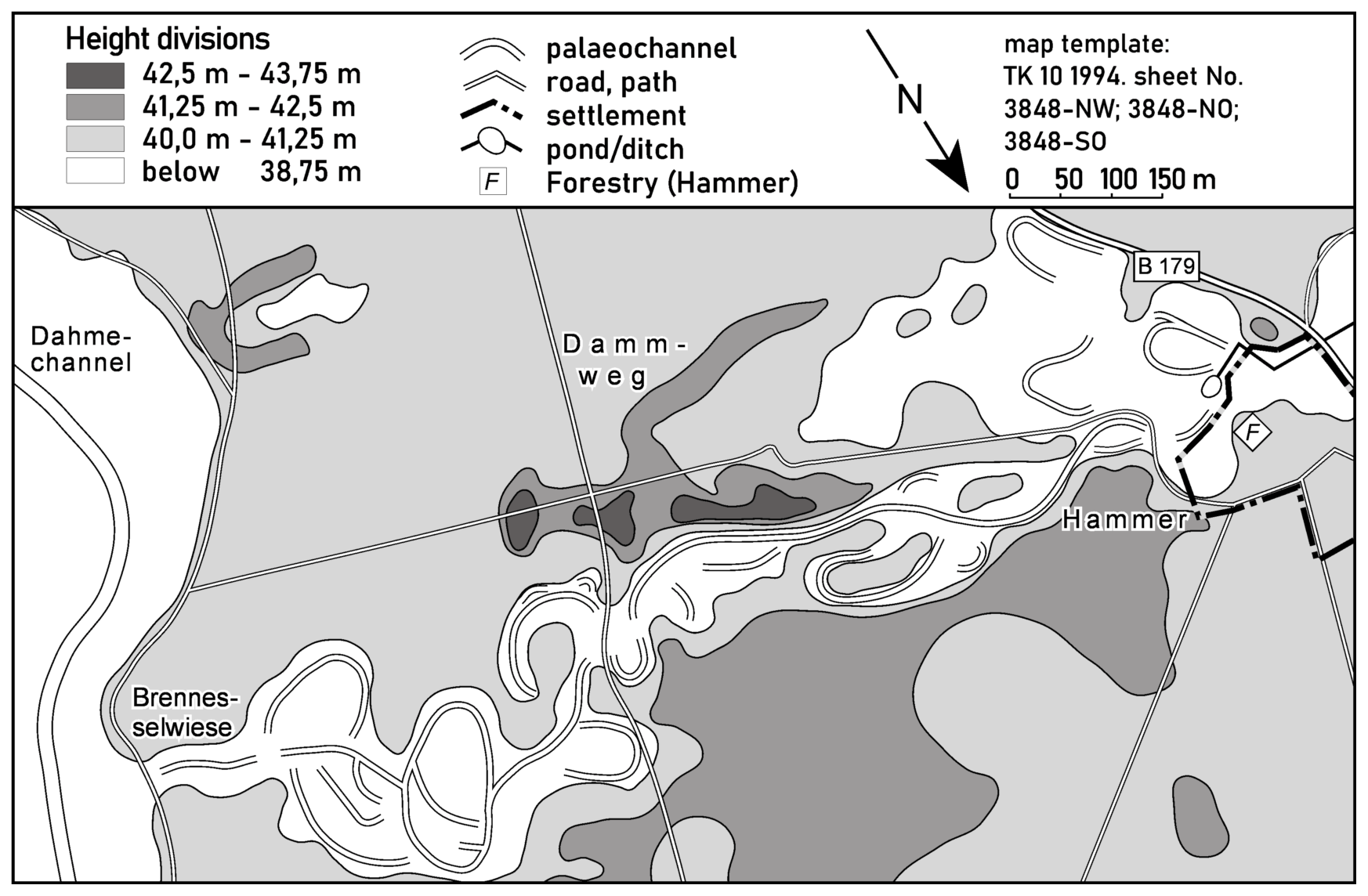
Figure 6The system of late glacial meandering palaeochannels at the forester's lodge Hammer.
This drainage path lasted until the dead ice that sealed the channel had thawed. The dune ridge near Klein Hammer sagged to such an extent that the river could break through. In consequence, the Stintgraben lowland fell dry.
While no exact dating is available from the palaeochannels of Stintgraben, in the south-eastern part of Berlin (Köpenick) comparable palaeochannels of the river Dahme could be dated to Allerød times (Grünert, 2002).
3.5 The late glacial and Holocene phase
Following the beginning of the Bølling–Allerød phase, the last dead ice, preserved in the channels, largely thawed away. The climate warming at the beginning of the late glacial interstadial resulted in gradual reforestation, which was accompanied by a decrease in aeolian processes. In contrast to the deep channels, most of the shallow basins were dry during the Early Holocene. Due to the rise in the groundwater table at the transition from the Boreal to the Atlantic most of the basins became wet and peat growth was initiated. Muds and gyttja accumulated in the lake basins of the Dahme channel until peat growth commenced there. On the shores of the lakes of the Dahme channel, flint artefacts have been found, indicating the presence of Neo- and Mesolithic people in the early Atlantic period.
In historical times, the landscape of the basin of Märkisch Buchholz underwent a comprehensive transformation through increasing anthropogenic influence. Extensive clearing has transformed pine and oak forests into pasture and arable land. Pine forests were planted on dunes and sandy sites far from the groundwater table. The operation of the mill Hermsdorfer Mühle certainly led to a locally limited increase in the groundwater level. On the other hand, a large number of the above-mentioned Luche basins, wetlands inside the Dahme channel, damp sandy sites and the entire lower Stintgraben lowland were drained by means of ditches (Stintgraben, Laufgraben, Grenzgraben) in order to open them up to agricultural use. The construction of the artificial channel “Dahme-Umflutkanal” (to prevent floodwaters) completely straightened the river Dahme. These measures have largely ended peat growth and partially destroyed existing peat sites.
In forestry, efforts to overcome the long-running monoculture have been evident in recent years with the establishment of young pine–oak and pine–beech woodland plantations. However, the nature conservation measures planned by the environmental authorities so far have not been sufficient to preserve the wet landscapes of the sandy basin of Märkisch Buchholz.
Reaching up to 144 m a.s.l., the Krausnick hills are by far the highest morainic plateau in the young moraine area to the south and south-east of Berlin. They form a remarkable contrast to the flat landscape of the Spreewald area.
The hills in their current shape are interpreted as being formed by several ice advances. While the main formation of the hills as an elevated area can be dated back to the Saalian Ice Age, the current surface and the near-surface sediments were mainly formed during the ice advance of the last Scandinavian ice sheet (SIS). Thus, older sediments can only be found in former clay pits on the northern slopes of the hills.
The Krausnick hills are crossed by the terminal moraines of the Brandenburg ice stage. This is in contrast to the Oderin basin further west and the Spreewald area to the east, where no terminal moraines formed. The Krausnick hills have very well developed moraine ridges. They appear to be superimposed on the older moraine complex.

Figure 7Morphological scheme of the Krausnick hills and their surroundings.
The pre-existent elevated area acted like a pillar on the glacier of the last SIS. Even though it was completely covered by the youngest ice, it slowed down the expansion of the glacier further south. In contrast to this, the ice could advance further south in the adjoining low-elevation area of Unterspreewald. Therefore, the direction of the ice advance in the southern part of the Krausnick hills was from the east to south-east rather than from the north (Fig. 7). This unusual direction can be demonstrated by the course of the glacial channels in the western part of the Unterspreewald area. There, the channels are directed approximately from east to west. This led to an intriguing situation: there are two ridges of terminal moraines running east to west across the Krausnick hills. While the northern ridge was formed by the typical southward-advancing glaciers, the southern ridge was formed by glaciers advancing from the east to south-east. Between the two ridges there is a narrow, elongated outwash plain indicating a glacier mouth directly on top of the Krausnick hills. Further to the west, the narrow plain changes into a wide outwash plain called the “Brand”. In addition to the above-mentioned glacier mouth the Brand was fed by meltwaters from two other mouth areas. Both areas are characterised by their undulating surface and a wealth of kettle holes.
In earlier times, the Krausnick hills were mainly used as pasture woodland. As witnesses of this use, some large and old oaks are still present.
Underlying data can be found at https://doi.org/10.18452/14585 (Juschus, 2001). A list of the raw data for the fieldwork can be found in the Appendix of the file Juschus.pdf.
OJ wrote Sect. 1 as a literature review. Section 2 was written by OJ. For this section, the results of the joint fieldwork of OJ and MB were used. In addition, existing literature was evaluated. Section 3 was written mainly by LB, with additions by OJ. The results of LB's fieldwork were used for this section. Section 4 was written by OJ. For this section, the results of the joint fieldwork of OJ and MB were used. Figures 1, 2, 3, and 7 were made by OJ, and Figs. 4, 5, and 6 were made by LB.
The contact author has declared that none of the authors has any competing interests.
Publisher’s note: Copernicus Publications remains neutral with regard to jurisdictional claims in published maps and institutional affiliations.
Berendt, G.: Geognostische Beschreibung der Gegend von Berlin, Zugleich Erläuterung zu der Geologischen Übersichtskarte der Umgegend von Berlin 1 : 100 000, Königlich Preußische Geologische Landesanstalt Berlin, 1880.
Böse, M.: Beobachtungen zu Eiskeilpseudomorphosen im Hangenden des Rixdorfer Horizontes in der Sandgrube Niederlehme, Brandenburgische Geowissenschaftliche Beiträge, 4, 45–51, 1997.
Cepek, A. G.: Schichtenfolge und Position des “Rixdorfer Horizontes”, Kurzreferate und Exkursionsführer 25 Jahre AK Quartärgeologie, Ges. Geol. Wiss. DDR, 19–21, 1986.
Genieser, K.: Neue Daten zur Flußgeschichte der Elbe, Eiszeitalter und Gegenwart, 13, 141–156, 1957.
Grünert, J.: Zur Genese der Niederungen Krumme Lake und Neue Wiesen in Berlin-Köpenick – Ein Beitrag zur Gewässernetzentwicklung im norddeutschen Jungmoränenland, Brandenburgische Geowissenschaftliche Beiträge, 10, 165–172, 2003.
Hermsdorf, N.: Zur quartären Schichtenfolge des Teltow-Plateaus, Brandenburgische Geowissenschaftliche Beiträge, 1, 27–37, 1995.
Hermsdorf, N.: Die Sandgrube Niederlehme – ein klassischer Aufschluß des Rixdorfer Horizontes, Brandenburgische Geowissenschaftliche Beiträge, 7, 173–181, 2000.
Hermsdorf, N.: Geologische Übersichtskarte 1 : 100 000 Landkreis Dahme-Spreewald inkl. Beiheft, Landesamt für Bergbau, Geologie und Rohstoffe Brandenburg, ISBN 978-3-7490-4173-2, 2007.
Juschus, O.: Das Oderiner Becken – spätpleistozäne und holozäne Landschaftsentwicklung im Bereich der Brandenburger Eisrandlage südlich von Berlin, Stuttgarter Geographische Studien, 126, 78–92, 1997.
Juschus, O.: Das Jungmoränenland südlich von Berlin – Untersuchungen zur jungquartären Landschaftsentwicklung zwischen Unterspreewald und Nuthe, Humboldt-Universität zu Berlin, Mathematisch-Naturwissenschaftliche Fakultät II, https://doi.org/10.18452/14585, 2001.
Juschus, O.: Das Jungmoränenland südlich von Berlin – Untersuchungen zur jungquartären Landschafts-entwicklung zwischen Unterspreewald und Nuthe, Berliner Geographische Arbeiten vol. 95, ISBN 3-9806807-2-X, 2003.
Juschus, O. and Błaszkiewicz, M.: Zur Genese fossilführender Sedimente in Nordpolen und Brandenburg – die Gniewer Folge (Seria gniewska) und der Rixdorfer Horizont, Brandenburgische Geowissenschaftliche Beiträge, 9, 85–96, 2002.
Lembke, H.: Von der “Urspree” zum heutigen Spreelauf, in: Landeskundl. Forschungen, Festschrift für Norbert Krebs zum 60. Geburtstag, J. Engelhorns Nachfolger Stuttgart, 140–145, 1936.
Litt, T., Behre, K.-E., Meyer, K.-D., Stephan, H.-J., and Wansa, S.: Stratigraphische Begriffe für das Quartär des norddeutschen Vereisungsgebietes, E&G Quaternary Sci. J., 56, 7–65, https://doi.org/10.3285/eg.56.1-2.02, 2007.
Lüthgens, Ch., Krbetschek, M., Böse, M., and Fuchs, M.: Optically stimulated luminescence dating of fluvioglacial (sandur) sediments from north-eastern Germany, Quat. Geochronol., 5, 237–243, 2010.
Marcinek, J.: Über die Entwicklung des Baruther Urstromtales zwischen Neiße und Fiener Bruch, Ein Beitrag zur Urstromtaltheorie, Wissenschaftliche Zeitschrift der Humboldt-Universität zu Berlin, Math.-Naturwiss. Reihe 10, 13–46, 1961.
Wahnschaffe, F.: Die Eiszeit in Norddeutschland, Richard Müller Verlag, Berlin, 1910.
- How to cite
- Abstract
- Dedication
- Introduction
- Stop one: the Niederlehme sandpit
- Stop two: late glacial to Holocene development of the river Dahme in the basin of Märkisch Buchholz
- Stop three: the southern margin of the (last) northern glaciation – morphology and land use history of the Krausnick hills
- Data availability
- Author contributions
- Competing interests
- Disclaimer
- References