 | 09 Sep 2024
Brunhes to burials – loess region of Krems, Lower Austria
Robert Peticzka
Christine Thiel
Birgit Terhorst
Sprafke, T., Peticzka, R., Thiel, C., and Terhorst, B.: Brunhes to burials – loess region of Krems, Lower Austria, DEUQUA Spec. Pub., 5, 41–54, https://doi.org/10.5194/deuquasp-5-41-2024, 2024.
This excursion is dedicated to loess–paleosol sequences (LPSs) and the Quaternary research history in the region around Krems an der Donau (Krems a.d. Donau), Austria. The landscape at the eastern exit of the picturesque Wachau valley, carved by the Danube into crystalline basement rocks, is covered by thick loess and has a more than 100-year-long research history. Local Upper Paleolithic findings (e.g., Venus of Willendorf, Fanny of Stratzing, Wachtberg infant burials) are world famous. The outcrops of Paudorf, Göttweig-Furth, and Krems-Schießstätte were type localities of the Quaternary period until the 1970s. Recently, these complex LPSs with discontinuities and polygenetic units were reinvestigated, with a focus on the Middle to Late Pleistocene (Brunhes) record.
- Article
(11243 KB) - Full-text XML
- BibTeX
- EndNote


Loess exposures are among the most instructive Quaternary paleoenvironmental archives. Loess–paleosol sequences (LPSs) record phases of morphodynamic activity and stability, mainly driven by climatic variations (Pécsi and Richter, 1996; Rohdenburg, 1970). Sedimentological approaches support paleoenvironmental reconstructions from loess packages (Antoine et al., 2009; Újvári et al., 2016), whereas paleopedological work is required for paleosols, which represent distinct paleoecological conditions of a certain duration (Bronger, 1976; Sprafke, 2016). Hiatuses and polygenetic units complicate paleoclimatic interpretations but add insights into geomorphic evolution (Lehmkuhl et al., 2021, 2016).
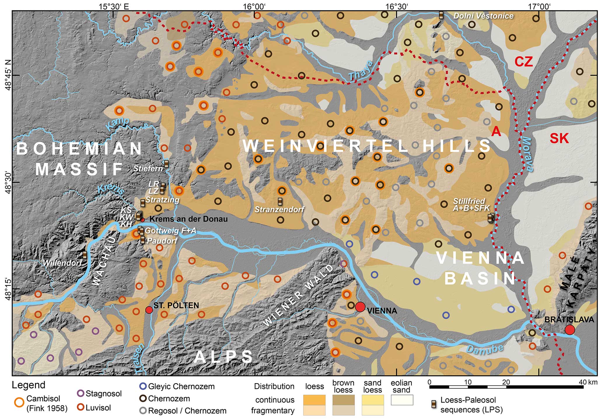
Figure 1Topography, eolian sediments, soils from loess (soil types tentatively adapted to IUSS Working Group WRB, 2022), and LPSs in northeastern Austria, based on Loishandl and Peticzka (2005), Fink (1958), and Fink and Nagl (1979); hillshade from USGS (2014). Humid loess landscape located around St. Pölten and further west, transition area to the north along the Bohemian Massif eastern margin, and dry loess landscape further east (Fink, 1965). LR, LZ: Langenlois Red Outcrop, Langenlois Ziegelei (brickyard) Kammerer; KS, KW, KH: Krems-Schießstätte, Krems-Wachtberg, Krems-Hundssteig; F+A: Furth and Aigen.
The region around Krems an der Donau (Krems a.d. Donau) (Fig. 1) in Lower Austria, at the eastern end of the Wachau valley, is widely known for thick LPSs (< 40 m) and has a long research tradition (Petschko et al., 2022; Riedl et al., 2022). In the first half of the 20th century, local LPSs provided a stratigraphic framework for enclosed Paleolithic findings, foremost the world-famous Venus of Willendorf (Bayer, 1913, 1909). Important recent discoveries are the Venus of Galgenberg (Neugebauer-Maresch, 1993) and the Wachtberg double infant burial (Einwögerer et al., 2006). Famous loess outcrops in this area are Paudorf, Göttweig, and Krems, which were type localities of the Quaternary (Bayer, 1913; Fink, 1961, 1956; Götzinger, 1936; Kovanda et al., 1995), before the emergence of marine stratigraphy in the 1970s (Emiliani, 1955; Shackleton and Opdyke, 1973).
Local LPSs are mainly located in slope positions; due to erosional and colluvial processes the LPSs contain discontinuities and polygenetic units. Detailed macro- and micromorphological observations coupled with numerical ages have helped to unravel the formation processes and their timing (Sprafke et al., 2014). Colorimetric and granulometric data from samples taken in high vertical resolution along a continuous column (Antoine et al., 2009) have proven exceptionally useful for stratigraphic differentiation (Sprafke, 2016; Sprafke et al., 2020).
This field trip aims to present concepts and data from the last 15 years of research against the background of more than 100 years of variegated research history. Unless indicated otherwise, figures relate to Sprafke (2016) with modifications.
1.1 Physical geography of the excursion area
The excursion area is located in the surroundings of Krems a.d. Donau in the western part of Lower Austria. The Wachau region and the “Weinviertel” region further east are known for the rather continental, “Pannonian” climate (Nagl, 1983). The considerable climatic gradient between the oceanic northwest (700–900 mm m.a.p.) and the continental northwest (500-600 mm m.a.p.) is related to the Bohemian Massif acting as a barrier for Atlantic moisture brought by the westerlies. This highland (∼ 500–1000 m a.s.l.) represents the remaining crystalline basement of the Paleozoic Variscan orogen (Matura, 2006). The lowlands (∼ 180–500 m a.s.l.) between the Alps and the Bohemian Massif are mainly filled with molasse sediments deposited during the Alpine orogeny. During the late Neogene to the Quaternary the Danube and its tributaries removed a considerable amount of these sediments and left fluvial deposits (Wessely and Draxler, 2006), which are present in terraces of varying altitudes and degrees of preservation. Like the Pleistocene fluvial deposits, the widespread loess cover was deposited during cold stages (Fig. 1). The connection of terraces and loess stratigraphy has remained difficult, due to incomplete records and different tectonic impact (Sprafke, 2021). The present-day soil cover in the loess area reflects climatic differences. Southwest of the Bohemian Massif there are (often Stagnic) Luvisols (Ah–E–Bt–C profile), whereas mainly Chernozems (Ah–C profile) developed on a comparable substrate further east, representing forest and steppe soils, respectively (Fink et al., 1979; IUSS Working Group WRB, 2022).
1.2 Loess landscapes and paleosols in Austria
Based on the obvious differences in soil cover and observations in the loess record, Fink (1956) postulated a subdivision of the Austrian lowlands into three loess landscapes (Fig. 2). The humid loess landscape (Feuchte Lösslandschaft) west of the Bohemian Massif with Holocene Luvisols from loess also exhibits a Bt horizon representing the last interglacial, which is superimposed by colluvial layers (“Linz complex”). The dry loess landscape (Trockene Lösslandschaft) east of the Bohemian Massif, characterized by Chernozems, hosts a Bw horizon representing the last interglacial, which is superimposed by a stack of humic horizons divided by thin loess layers (“Stillfried complex”). This pedostratigraphic concept basically remains valid until today, whereas the transition area (Übergangsgebiet) in between the humid and dry loess landscape and its pedostratigraphy were the subject of considerable controversies (Fink, 1979b; Sprafke, 2021).
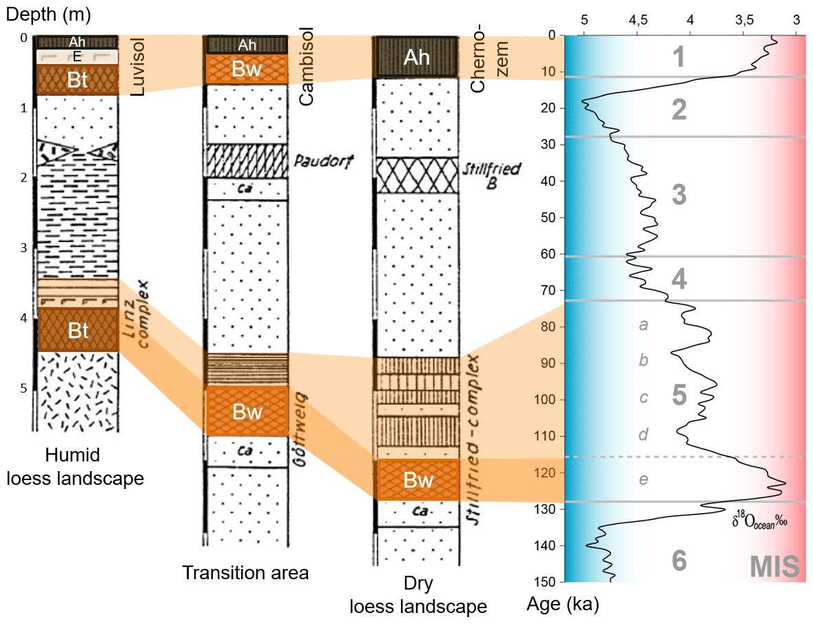
Figure 2The classic pedostratigraphic model of Austrian LPSs (Fink, 1965) and correlation with the marine oxygen isotope record (Railsback et al., 2015). The proposed chronostratigraphy of the transition area (Fink, 1976) is no longer valid.
Paudorf, Göttweig, and Krems were established in the 1960s as key units of Quaternary stratigraphy (Fink, 1961, 1965), as the thick LPSs of the transition area are unique for central Europe and were thought to be rather complete. The ∼ 1–2 m thick paleosol Göttweiger Verlehmungszone (GVZ) was first thought to represent a warm Aurignacian (early Upper Paleolithic) period, followed by loess deposition during the colder Gravettian (Bayer, 1913); 2 decades later, a ∼ 1 m thick humic, slightly weathered pedocomplex in the upper part of the Paudorf loam pit (Paudorfer Bodenbildung) was attributed to a major interstadial of the last glacial, whereas the 2 m thick pedocomplex in the lower part of the profile was correlated to the GVZ and the last interglacial (Fink, 1956; Götzinger, 1936). Further, in the outcrop of Krems-Schießstätte, a pedocomplex that was thought to represent the GVZ was recognized (Fink, 1976: KR4 paleosol). A ∼ 3–4 m thick complex of rather strongly weathered soils below KR4 (Kremser Komplex; Fink, 1976: KR7–9) was attributed to a previous long interglacial (Fink, 1961).
However, fundamental revisions had to be accepted in the 1970s in the context of a Czech–Austrian collaboration. Mollusks in the Paudorfer Bodenbildung indicated its formation during the last interglacial, and the Göttweiger Verlehmungszone was related to a Middle Pleistocene interglacial (Fink, 1969). As the Matuyama–Brunhes boundary (MBB) was detected in the upper part of Krems Schießstätte, just below KR4, the Kremser Komplex clearly had an Early Pleistocene age (Fink, 1976; Fink and Kukla, 1977). Thermoluminescence ages by Zöller et al. (1994) supported the main revision of Paudorf and Göttweig. Krems-Schießstätte remained well known for its Early Pleistocene record (Kukla and Cílek, 1996). Noteworthy are works at these type localities in the context of a geological survey in the Weinviertel region (Kovanda et al., 1995).
Recent investigations of still-accessible outcrops in the Krems region started over 15 years ago. Fundamental advances in luminescence dating have allowed for more precise interpretations and correlations for about the last 300 kyr (Terhorst et al., 2011; Thiel et al., 2011a, b, c). Paleoenvironmental reconstruction from the polygenetic LPSs of the transition area have focused on the Brunhes record (Sprafke, 2016; Sprafke et al., 2013, 2014). In recent years, the last glacial LPSs have received increasing attention, often related to Upper Paleolithic sites (Groza et al., 2019; Hambach, 2010; Händel et al., 2021; Lomax et al., 2014; Meyer-Heintze et al., 2018; Nigst et al., 2014; Reiss et al., 2022; Sprafke et al., 2020; Terhorst et al., 2015; Zeeden et al., 2015; Zöller et al., 2014).
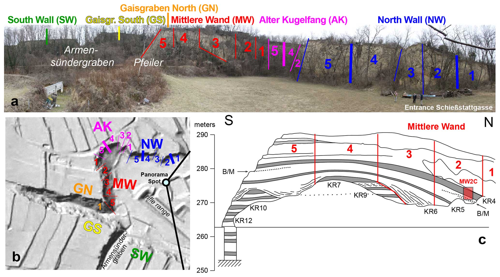
Figure 3Krems-Schießstätte. (a) Panoramic photo and (b) hillshade with outcrop sectors. (c) Mittlere Wand (Fink, 1979a).
The spur between the Krems and Danube rivers in the north of the picturesque city of Krems a.d. Donau is covered by an LPS of up to 37 m thickness, reaching back into the Early Pleistocene, partly exposed at Krems-Schießstätte (Stop 2; Fink, 1976). At the southeast-exposed slope, up to 10 m thick Late Pleistocene loess contains several Upper Paleolithic occupation layers, which have been the subject of excavations for > 100 years (Einwögerer et al., 2009; Neugebauer-Maresch, 2008). From 2005 to 2015, excavations at the site of Krems-Wachtberg (48°24′53.95′′ N, 15°35′58.39′′ E; no more profiles accessible due to house construction) (Händel et al., 2014) largely focused on archeological horizon (AH) 4, at ∼ 5.5 m depth, dated to ∼ 31.2 ka (Simon et al., 2014), where buried infants were discovered in 2005 (Einwögerer et al., 2006). The adjacent ca. 8 m thick LPS has no major discontinuities and spans a time range from ∼ 20–40 ka (Lomax et al., 2014; Sprafke et al., 2020). Magnetic proxy variations and field stratigraphic units (incipient paleosols, tundra gley soils, reworked units, loess) have been tentatively correlated to the Greenland ice core record (Hambach et al., 2010; Heiri et al., 2014; Terhorst et al., 2014). High-resolution color and grain size analyses and available age information were recently integrated into a unified chronostratigraphic framework, revealing that, contrary to the western central European reference LPS Nussloch, Heinrich events did not result in thick dust accumulation but rather in reworking within a polar desert ecosystem (Sprafke et al., 2020).
Krems-Schießstätte (48°25′0.99′′ N, 15°35′48.25′′ E) is a large outcrop (Fig. 3) that was repeatedly the subject of investigations during the last century. Noteworthy are the joint Czech–Austrian investigations in the late 1960s and early 1970s, taken up in the 1990s (Kovanda et al., 1995). Most work has focused on the Mittlere Wand, where the majority of the paleosols is exposed and the Matuyama–Brunhes boundary (MBB) and older magnetic field reversals were traced (Fink, 1976). The investigations in the late 1960s to 1970s revealed the presence of 16 soil horizons that were labeled from top to bottom in ascending order. KR1 is the recent soil, and KR2 and KR3 are only weakly developed and could not be unambiguously traced in our detailed study of sector GN1. Therefore, KR4 is the only significant pedocomplex above the MBB (Fink and Kukla, 1977). Following these authors, Krems-Schießstätte may complement the Brno Red Hill LPS, which is seen as rather complete record of the Brunhes chron (see Sect. 6, Conclusions). A few years later, the Stranzendorf LPS, which is interpreted to reach back to the Pliocene, was used to complement the Red Hill–Krems succession to a whole central European record of glacial–interglacial cycles comparable to the long records of the Chinese Loess Plateau (Kukla and Cílek, 1996). A comprehensive review of these studies is given in Kovanda et al. (1995).
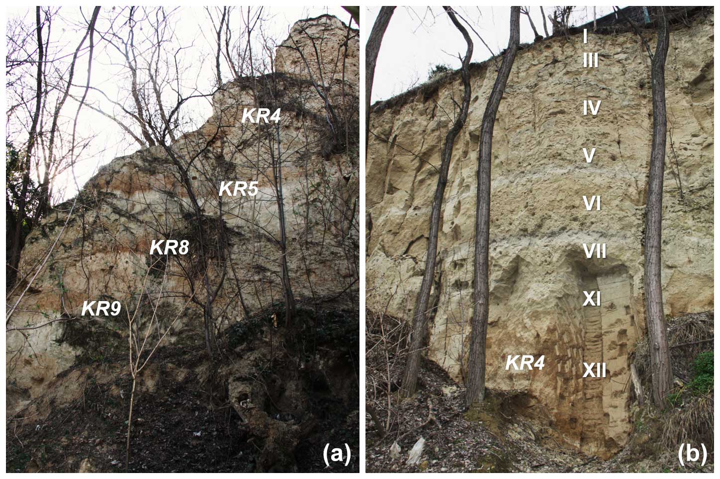
Figure 4Prominent paleosols in Krems-Schießstätte with KR labels (Fink, 1976; Fink and Kukla, 1977). (a) Sector MW5 with the (invisible) reported MBB between KR4 and KR5, below a major hiatus of KR8 and KR9 (see Fig. 3d). (b) Sector NW2 with the KR4 profile sampled in high resolution and stratigraphic designations by Sprafke (2016).
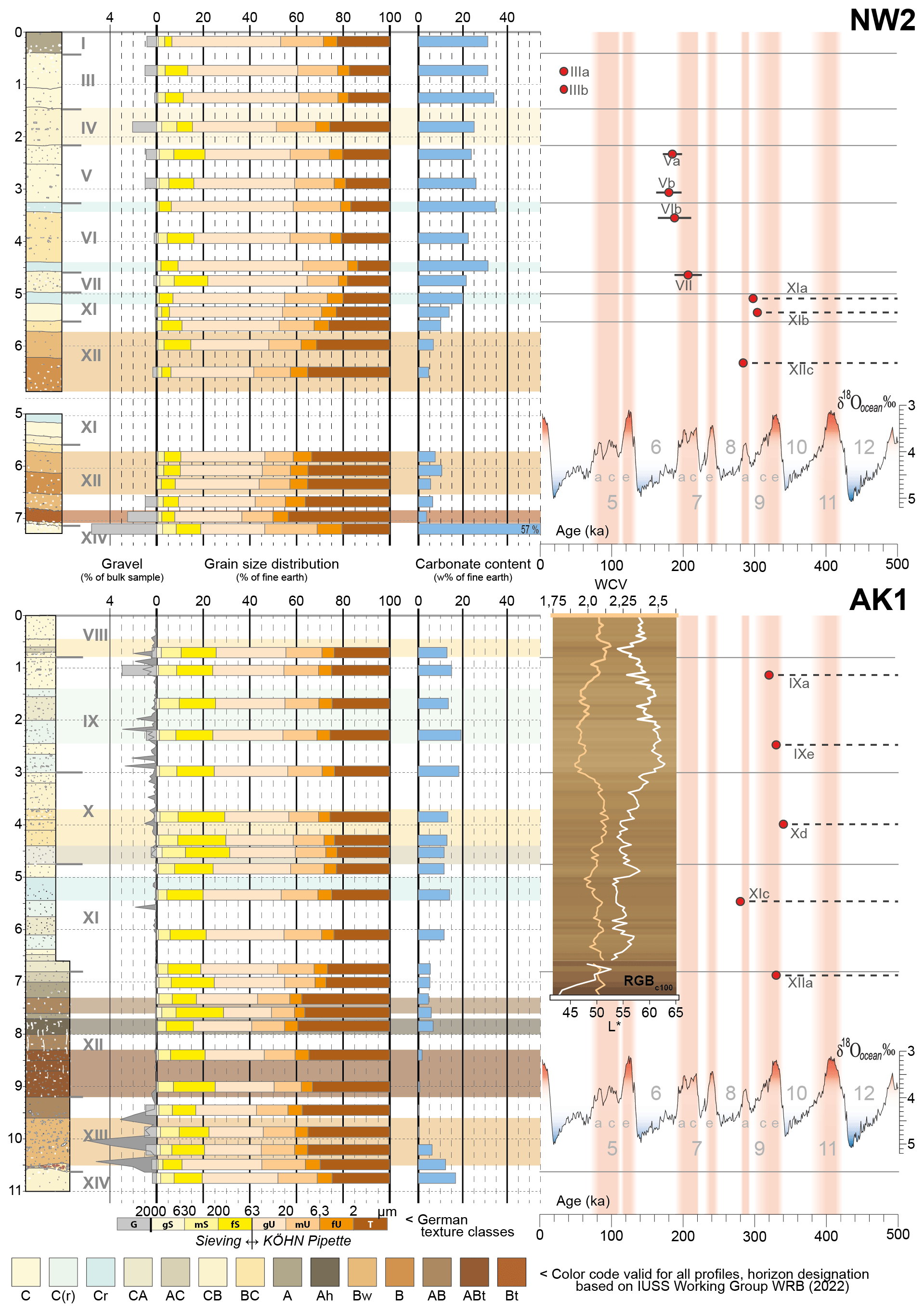
Figure 5Stratigraphy, granulometry, and carbonate contents of NW2 and AK1; loess colors at AK1 (details in Sect. 3.2); and preliminary luminescence ages against the marine oxygen isotope record (Railsback et al., 2015), adapted from Sprafke (2016).
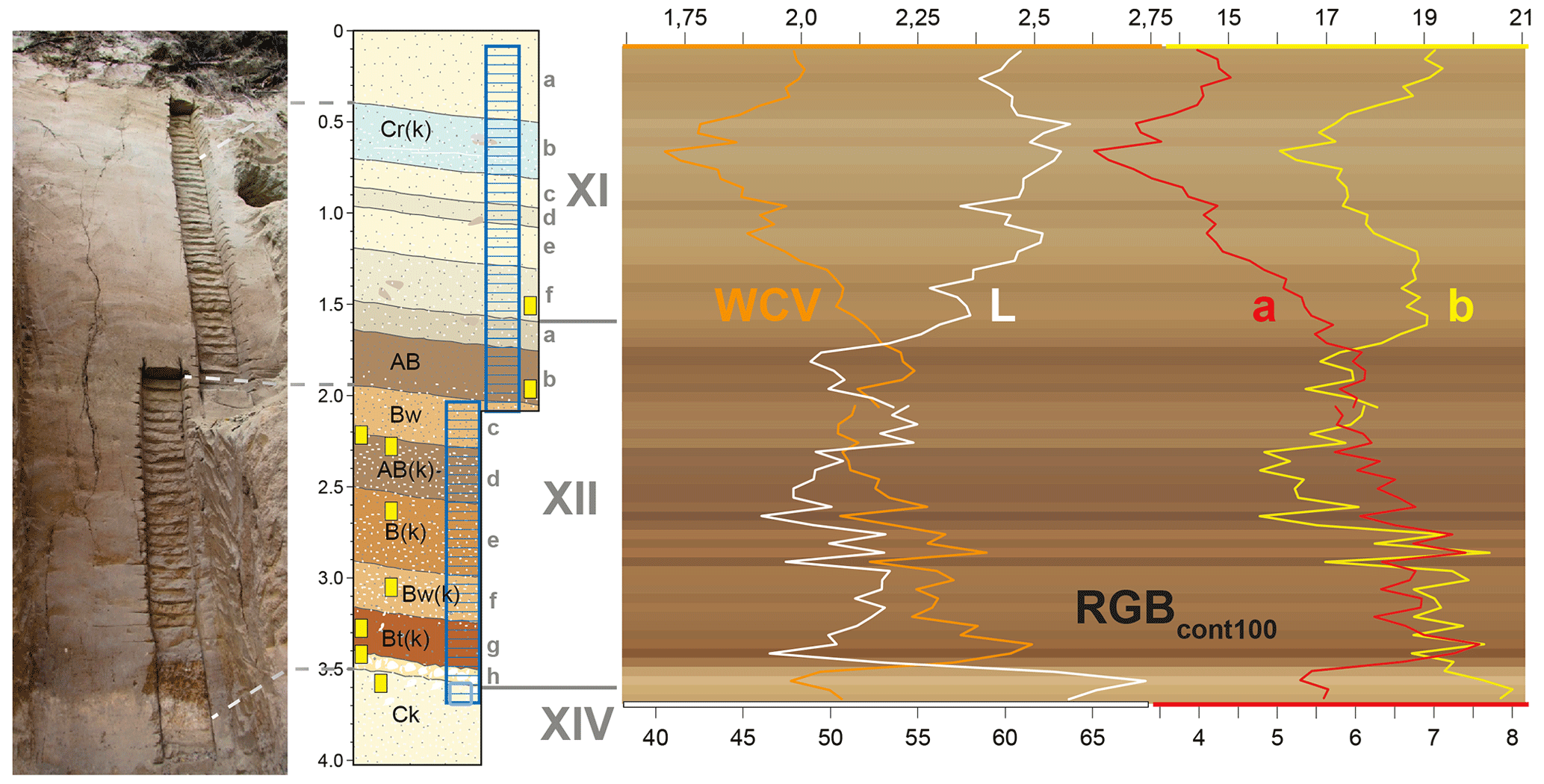
Figure 6Stratigraphy and color data (details in Sect. 3.2) of KR4 at MW2, adapted from Sprafke (2016).
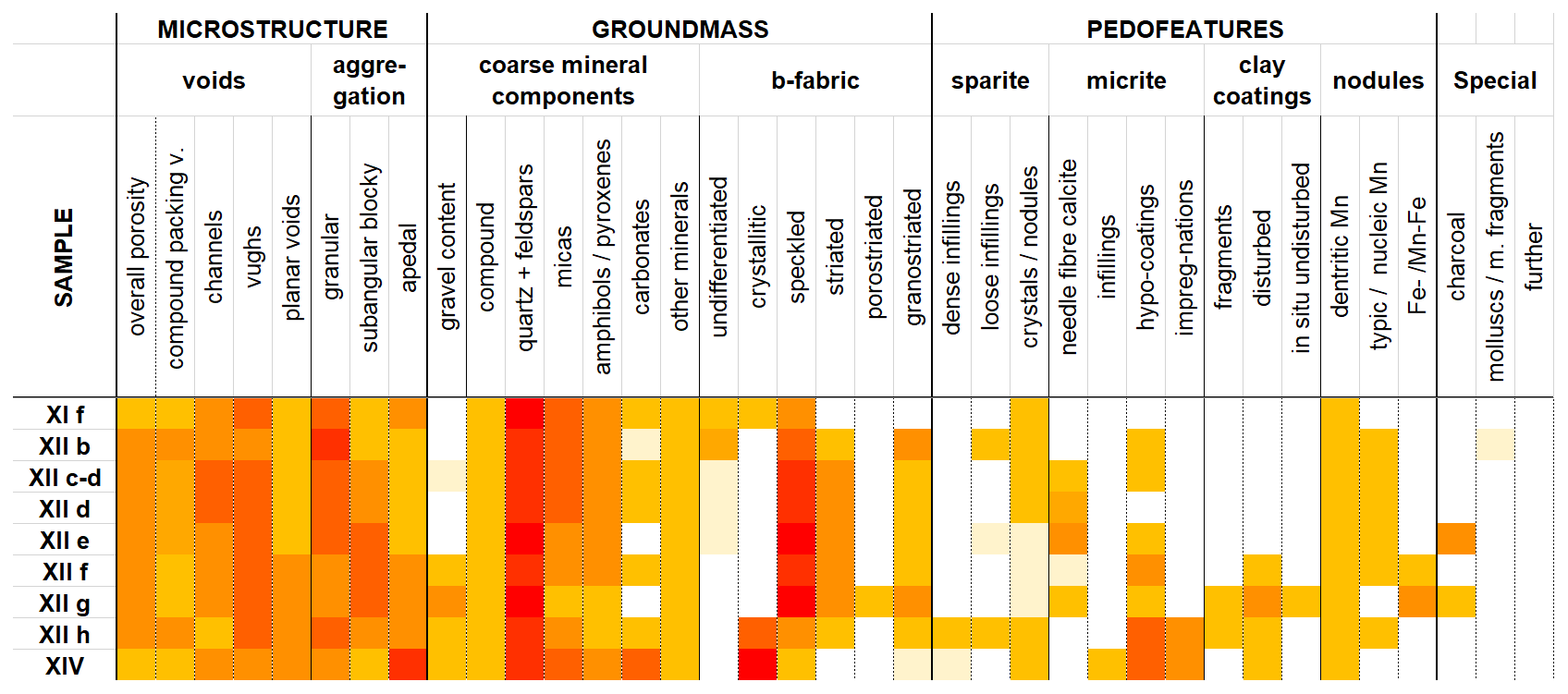
Figure 7Micromorphological characteristics (terms from Stoops, 2003) of KR4 at MW2, translated from Sprafke (2016).
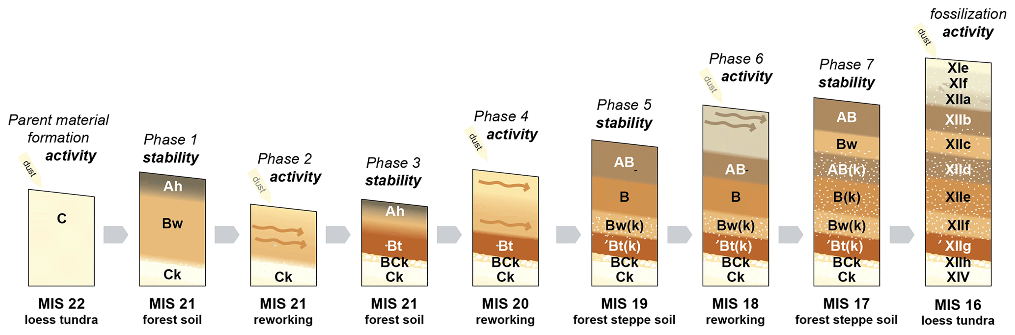
Figure 8Formation model of KR4 (at MW2) and tentative chronology and paleoenvironments, adapted from Sprafke (2016).
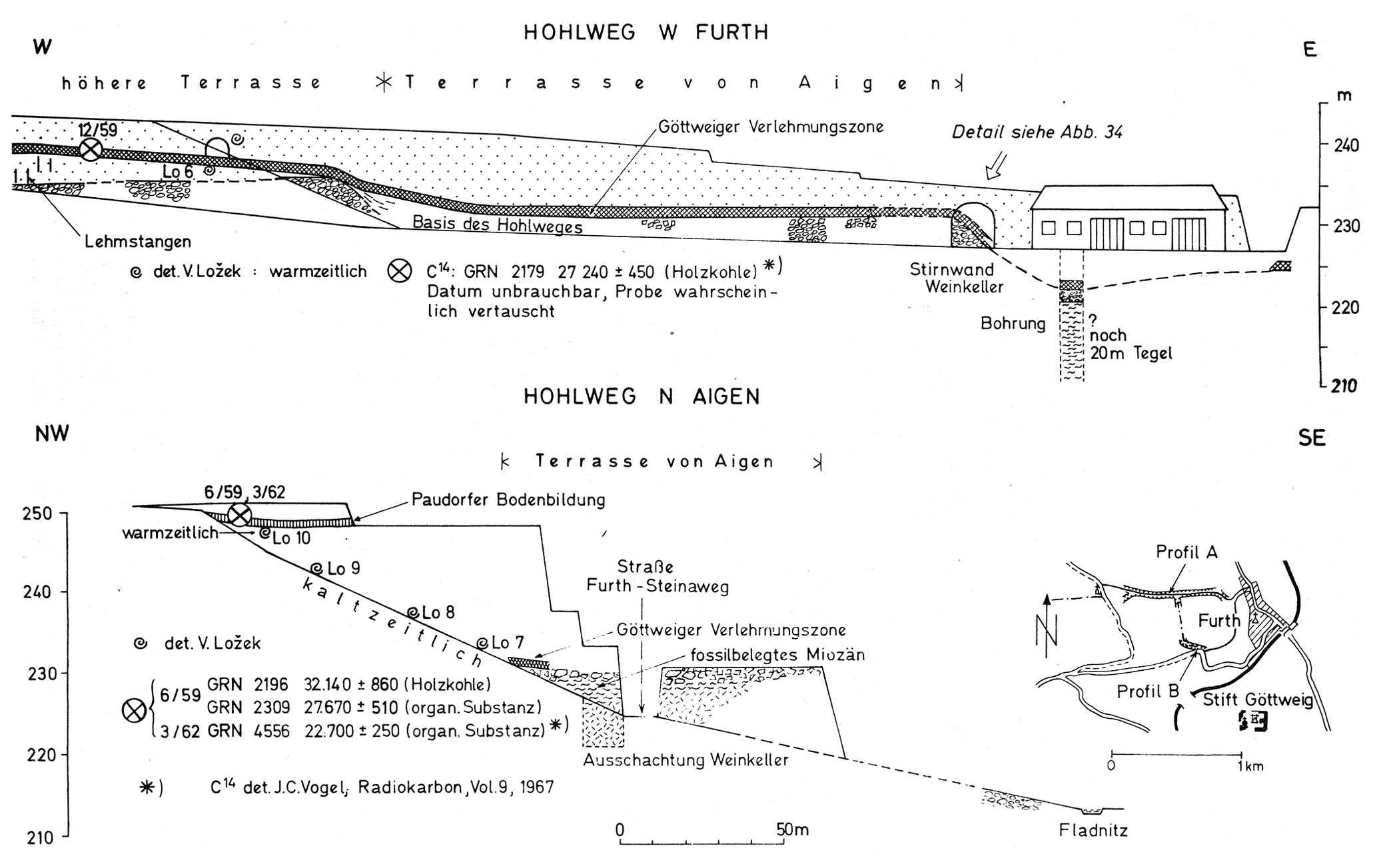
Figure 9Overview of Göttweig-Furth and Göttweig-Aigen from Fink (1976).
Recent investigations focused on the Brunhes record of Krems-Schießstätte (including KR4), with additional data from KR5 and KR7, both below the MBB. High-resolution color measurements and mesomorphological studies in representative sections of the wall facilitated the stratigraphic subdivision of the laterally variable outcrop walls. Distinct horizons were investigated in more detail using, e.g., micromorphology, and for distinct loess packages luminescence ages were determined.
3.1 Sector NW2
Entering the brickyard from the gate at Schießstattgasse, well-differentiated loess sediment above the characteristic KR4 pedocomplex is exposed at the outcrop wall on the right side (Fig. 4). Luminescence ages reveal marked discontinuities in the loess above KR4 (Fig. 5). While the topmost last glacial loess is rather uniform, the penultimate glacial loess consists of brownish loess enriched in coarser material next to pale horizons dominated by silt. The characteristic Unit VI can be traced along the entire outcrop. Below another considerable hiatus KR4 has a rather sharp lower boundary between a Bt and basal Ck horizon. The middle part shows advanced weathering but no signs of clay illuviation. A detailed study of KR4 will be presented in the profile of sector MW2. On the way along the North Wall into the Alter Kugelfang the pedocomplex stays at a comparable altitude, whereas loess between Unit VI and the KR4 pedocomplex strongly increases in thickness.
3.2 Sector AK1
Contrary to the neighboring AK2 and AK3 the profile at AK1 (Fig. 5) does not reach up to Unit VI but through the complete KR4, which is extraordinarily thick here, due to local deposition of soil sediments. Preliminary luminescence data indicate a minimum age of MIS 8 (marine isotope stage) for the succession of partly brownish and bleached loess sediments. The presence of a significant component of coarse material can be interpreted with the polygenetic development in the interplay of eolian sedimentation and in situ and colluvial processes, which is typical of most of the loess sediments of the Krems region. The closely spaced profiles of AK1–3 were compared based on field and sample observations and color data. The latter are measured by a spectrophotometer and allow for a robust subdivision of loess sediments and pedocomplexes. We use the warm–cold value (WCV) as a ratio of warm to cold colors (Sprafke et al. 2013), with L* indicating luminance, a* for red (> 0) vs. green (< 0), and b* for yellow (> 0) vs. blue (< 0); the background shows RGBc100, representing RGB colors with enhanced contrast. A limited profile depth of the outcrop walls below private gardens had an influence on color measurements, rendering a profile correlation based on color data alone challenging for this weakly differentiated material (Sprafke, 2016).
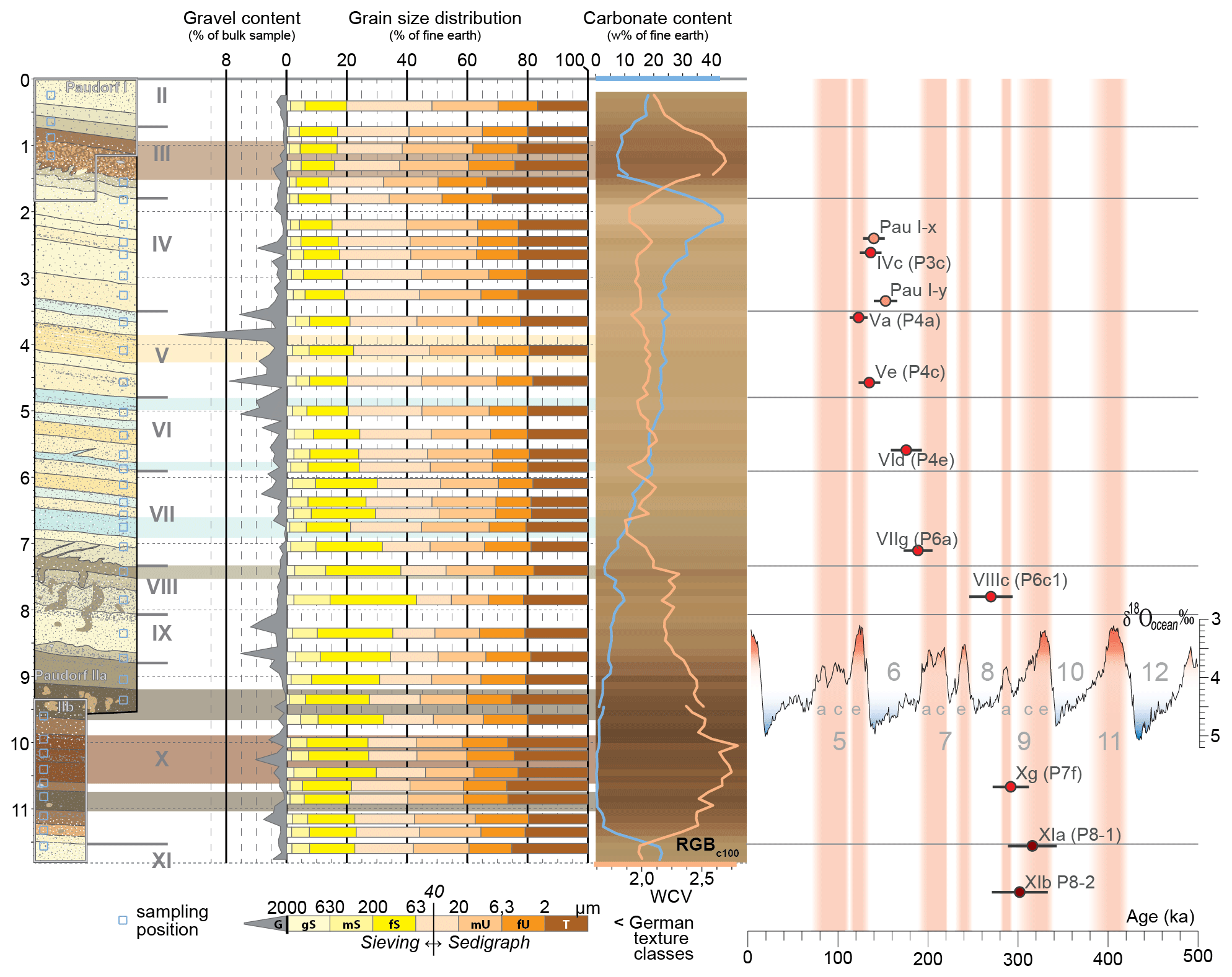
Figure 10Paudorf LPS (Sprafke, 2016), with grain size, carbonate, and color data from Sprafke et al. (2013). Grain size data from Sprafke et al. (2013). Luminescence ages are shown in the framework of the marine oxygen isotope record (Railsback et al., 2015; Sprafke et al., 2014).
3.3 Sector MW2
The KR4 pedocomplex is best differentiated in MW2, also shown in the standard sequence by Fink (1978). Here, KR4 has a Bt horizon in the bottom and is considerably weathered in the middle part; however, in the upper middle and in the topmost part weathered humic horizons are found. Color data, as presented in the sections before, also support the classification of well-developed soil horizons; oscillations are due to inhomogeneous, aggregated clay-rich material and secondary carbonate (Fig. 6). Semi-quantitative micromorphological analyses of different features following the terminology of Stoops (2003) (Fig. 7) are complemented by the qualitative assessment of feature constellations. Microstructure, primary carbonates, and clay coatings are key to classifying paleosols (Bronger, 2003, 1999) and to reconstructing polygenesis (Sprafke et al., 2014). Phases of pedogenesis and reworking are linked to paleoenvironmental variations; it is suggested that KR4 formed during up to three glacial interglacial cycles of the early Middle Pleistocene (Fig. 8).
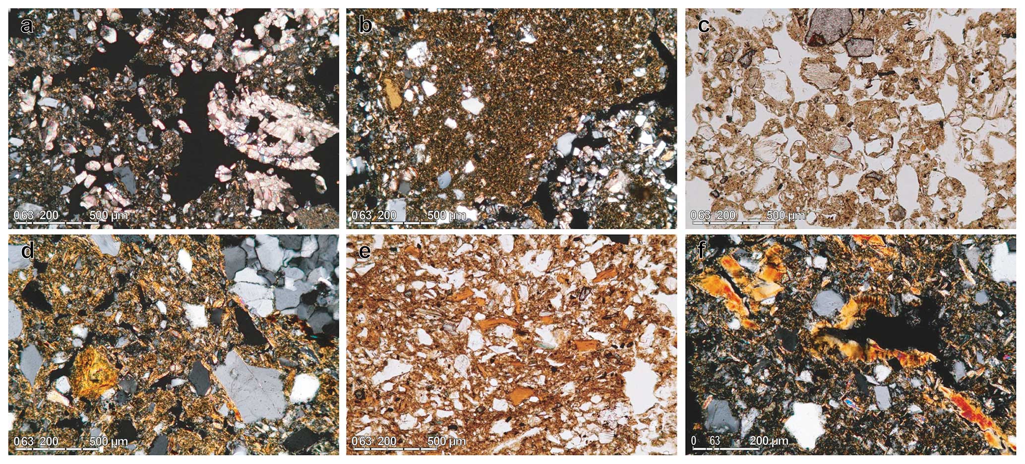
Figure 11Micromorphology of samples from Paudorf locus typicus. (a) Calcified root cell, partly disturbed by bioturbation (IIId). (b) Bw fragment (IIIc). (c) Granular structure (cryo- vs. bioturbation?) (VIIIa). (d) Rolled clay coatings in weathered groundmass (Xd). (e) Fragments of clay coatings (Xf1). (f) Clay coatings partly in situ (Xg).
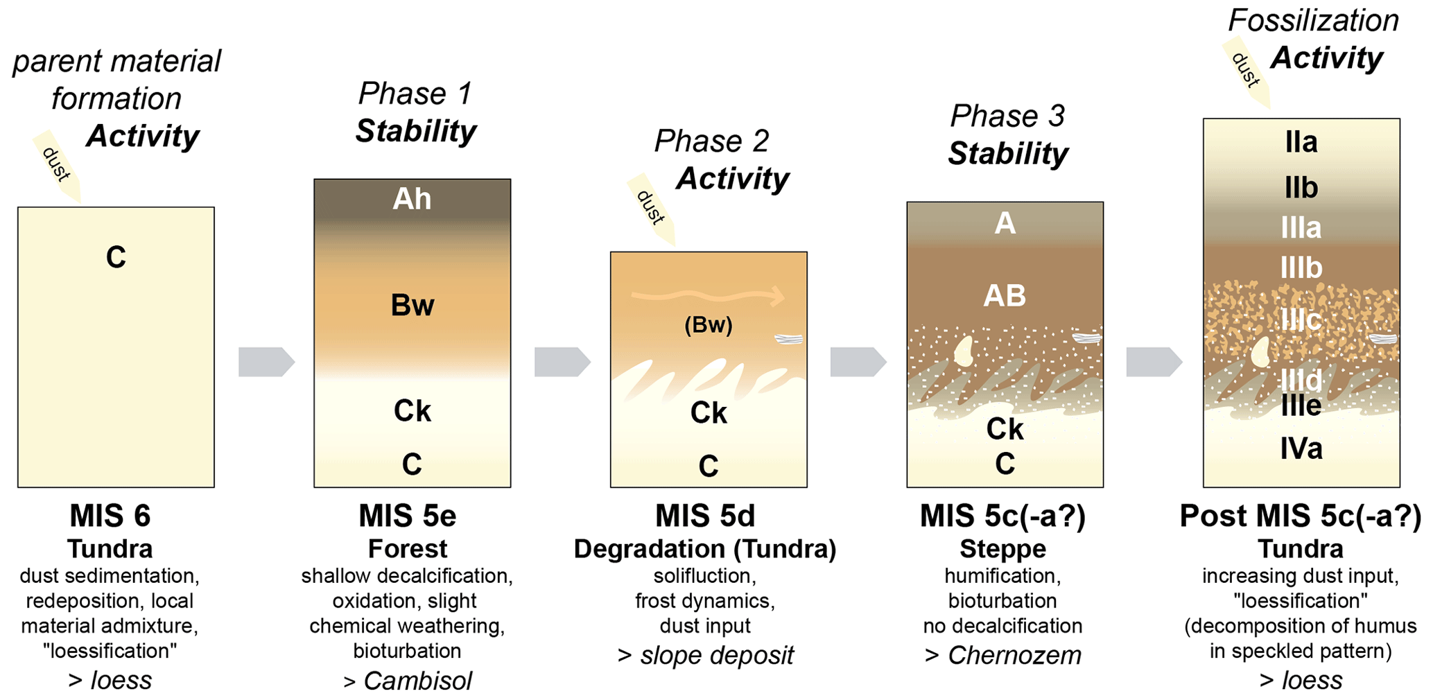
Figure 12Formation model of the upper pedocomplex (Unit III) at Paudorf during MIS 5, with main processes, tentative chronology in comparison to the MIS 5 pedocomplex at Stillfried, and related paleoenvironments.
3.4 Sectors MW3–GN1
Sectors MW3–5 provide some insights into the Matuyama record of Krems-Schießstätte Mittlere Wand (Fink, 1976; Fink and Kukla, 1977). At MW3, a strong inclination of paleosols KR4 and KR5 and a colluvium in the basal part are observed. At MW4, the Kremser Komplex (Fink, 1961) is exposed, consisting of KR9, KR8, and KR7, from bottom to top. KR7 is known as Krems soil (Brandtner, 1956) and the most weathered paleosol currently exposed at Krems-Schießstätte; it has a marked petrocalcic horizon at the base. A comparison of the color and micromorphology of KR7, the GVZ, and the basal Bw horizon of the Stillfried complex (Eemian) indicates overall moderate interglacial weathering intensities in the study area. Finally, at the southern corner of MW5 to GN1 (the Pfeiler), the oldest exposed parts of the whole outcrop are found (Fig. 4).
The Göttweiger Verlehmungszone (GVZ; 48°22′30.83′′ N, 15°36′13.49′′ E) exposed in the Zellergraben near Furth bei Göttweig crosses several terraces and loess sediments (Fig. 9). The GVZ was described over 100 years ago by archeologists, was suggested to represent a warm period of the Aurignacian (Bayer, 1913), and was later thought to represent an earlier interstadial of the last glacial period (Brandtner, 1956; Gross, 1960, 1956). Fink (1961) established the view that it was the last interglacial paleosol (Fink, 1960, 1956; Götzinger, 1936). The GVZ could not be bracketed by luminescence ages because the sample above already indicates an age older than the possible dating range, i.e., > 350 ka (Thiel et al., 2011b). A formation during MIS 11 and/or older interglacials is likely (Kovanda et al., 1995; Sprafke, 2016). In the upper part of the sequence, a few hundred meters to the south (Aigen), a paleosol comparable to the MIS 5 complex in Paudorf is exposed (Thiel et al., 2011b; Zöller et al., 1994).
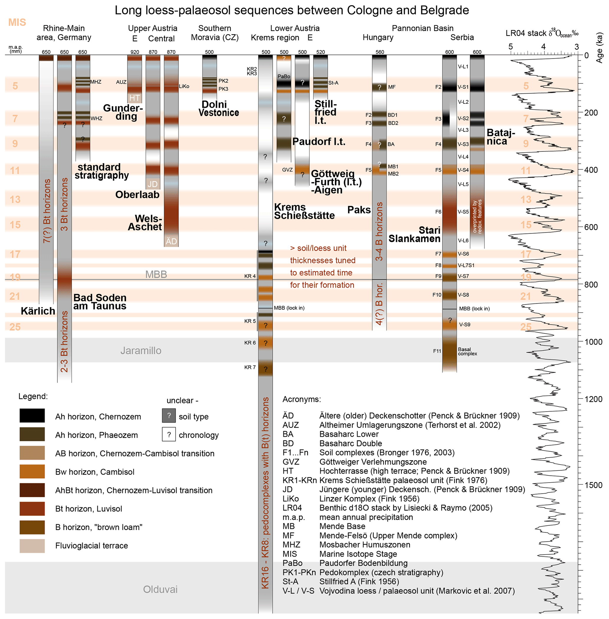
Figure 13Compilation of paleopedological records in a transect from central to southeastern Europe based on various sources (Antoine et al., 2013; Bibus, 2002; Boenigk and Frechen, 1998; Bronger, 2003; Lisiecki and Raymo, 2005; European Soils Bureau Network, 2005; Marković et al., 2009, 2011; Pécsi and Richter, 1996; Schmidt et al., 2011; Scholger and Terhorst, 2013; Semmel and Fromm, 1976; Terhorst, 2013; Terhorst et al., 2002; Zöller et al., 1988).
The loam pit in the northwest of Paudorf (48°21′22.93′′ N, 15°36′30.00′′ E), also known as Paudorf locus typicus (Brandtner, 1956; Fink, 1976, 1954, 1965; Götzinger, 1936; Terhorst et al., 2011; Zöller et al., 1994), is located at ∼ 260 m a.s.l. at the footslope of the Waxenberg (∼ 500 m a.s.l.). Two prominent paleosols are visible in the up to 11 m thick LPS (Fig. 10). These were studied in detail by Sprafke et al. (2014); slight modifications in the stratigraphy and pedocomplex evolution by Sprafke (2016) are due to insights from the Stiefern LPS and Krems-Schießstätte. The penultimate glacial loess of these sites shows interesting similarities, i.e., brownish horizons enriched in coarse material and bleached horizons with dominating silt. Next to eolian deposition and in situ alteration, the influence of slope processes is evident in the evolution of the local loess sediments, provoking questions on the loess definition (Sprafke, 2022; Sprafke and Obreht, 2016). The complex evolution of enclosed pedocomplexes requires thin-section studies and robust age control (Sprafke et al., 2014) (Figs. 11 and 12).
Based on the semi-quantitative analyses combined with a qualitative investigation, several stages of development were reconstructed for the pedocomplexes. The correlation of different stages for the MIS 5 is based on comparisons with nearby pedocomplexes with similar pedogenic intensities but higher temporal resolution, e.g., the Stillfried complex (Fink, 1954, 1979b; Zöller et al., 1994). For the MIS 9 pedocomplex (not shown), there are no nearby records for comparison; therefore the correlations with the marine isotope substages and reconstructed paleoenvironments are tentative (Sprafke, 2016).
The studied Middle to Late Pleistocene LPSs are polygenetic and discontinuous, and age control is limited (luminescence ages to about 300 ka; MBB is ca. 780 ka). However, some general conclusions can be drawn from the presented results if the paleopedological record is considered and combined with the concept of climate-phytomorphic soils (Bronger, 2003, 1976). Absence of significant clay illuviation indicates that during the last 1 Myr interglacial climates in Lower Austria were different than those in western central Europe but more similar to the Pannonian Basin (with minor deviations; Fig. 13). In turn, glacial periods had a central European character, indicated by the presence of tundra gleys. Yet, loess of the last glacial has revealed characteristic differences in landscape response to millennial-scale paleoclimatic fluctuations compared to western central Europe.
All data for Sprafke (2016) are available in an open-access manner from the University of Würzburg library repository (https://doi.org/10.25972/WUP-978-3-95826-039-9, Sprafke, 2016b).
This work is based on the PhD thesis of TS and was conceptualized and managed by TS (investigation) and BT (supervision, resources) with support from RP and CT. Luminescence data are from CT. TS wrote the text and created the visualizations; all co-authors reviewed and edited the paper.
The contact author has declared that none of the authors has any competing interests.
Publisher’s note: Copernicus Publications remains neutral with regard to jurisdictional claims made in the text, published maps, institutional affiliations, or any other geographical representation in this paper. While Copernicus Publications makes every effort to include appropriate place names, the final responsibility lies with the authors.
We thank the Schützenverein Krems 1440 for granting access to the Krems-Schießstätte outcrop. Many thanks go to Simon Meyer-Heintze, Sergey Sedov, and the Österreichische Akademie der Wissenschaften (ÖAW) archeologists for close collaboration and to the many students who worked with us in Krems and surroundings. For detailed acknowledgements, please refer to Sprafke (2016).
This open-access publication was funded by the Bern University of Applied Sciences.
Antoine, P., Rousseau, D. D., Moine, O., Kunesch, S., Hatté, C., Lang, A., Tissoux, H., and Zöller, L.: Rapid and cyclic aeolian deposition during the Last Glacial in European loess: a high-resolution record from Nussloch, Germany, Quaternary Sci. Rev., 28, 2955–2973, 2009.
Antoine, P., Rousseau, D. D., Degeai, J. P., Moine, O., Lagroix, F., Kreutzer, S., Fuchs, M., Hatté, C., Gauthier, C., Svoboda, J., and Lisá, L.: High-resolution record of the environmental response to climatic variations during the Last Interglacial-Glacial cycle in Central Europe: the loess-palaeosol sequence of Dolní Věstonice (Czech Republic), Quaternary Sci. Rev., 67, 17–38, 2013.
Bayer, J.: Jüngster Löß und paläolithische Kultur in Mitteleuropa, Jahrbuch für Altertumskunde, III, 149–160, 1909.
Bayer, J.: Die Gliederung des Diluviums in Europa, Mitteilungen der Geologischen Gesellschaft, 6, 188–196, 1913.
Bibus, E.: Zum Quartär im mittleren Neckarraum – Reliefentwicklung, Löß/Paläobodensequenzen, Paläoklima, Tübinger Geowissenschaftliche Arbeiten, D8, 236 pp., ISBN 3-88121-055-5, 2002.
Boenigk, W. and Frechen, M.: Zur Geologie der Deckschichten von Kärlich/Mittelrhein, E&G Quaternary Sci. J., 48, 38–49, https://doi.org/10.3285/eg.48.1.04, 1998.
Brandtner, F.: Lößstratigraphie und paläolithische Kulturabfolge in Niederösterreich und den angrenzenden Gebieten (Zugleich ein Beitrag zur Frage der Würmgliederung), E&G Quaternary Sci. J., 7, 127–175, https://doi.org/10.3285/eg.07.1.13, 1956.
Bronger, A.: Zur quartären Klima- und Landschaftsentwicklung des Karpatenbeckens auf (paläo-)pedologischer und bodengeographischer Grundlage, Kieler Geographische Schriften 45, Geographisches Institut, Universität Kiel, Kiel, 1976.
Bronger, A.: Löß-Paläoboden-Sequenzen Zentralasiens als Indikatoren einer globalen Kimageschichte des Quartärs?, E&G Quaternary Sci. J., 49, 35–54, https://doi.org/10.3285/eg.49.1.03, 1999.
Bronger, A.: Correlation of loess-paleosol sequences in East and Central Asia with SE Central Europe: towards a continental Quaternary pedostratigraphy and paleoclimatic history, Quatern. Int., 106, 11–31, 2003.
Einwögerer, T., Friesinger, H., Händel, M., Neugebauer-Maresch, C., Simon, U., and Teschler-Nicola, M.: Upper Palaeolithic infant burials, Nature, 444, 285–285, 2006.
Einwögerer, T., Händel, M., Neugebauer-Maresch, C., Simon, U., Steier, P., Teschler-Nicola, M., and Wild, E. M.: 14C Dating of the Upper Paleolithic Site at Krems-Wachtberg, Austria, Radiocarbon, 51, 847–855, 2009.
Emiliani, C.: Pleistocene temperatures, J. Geol., 63, 538–578, 1955.
European Soils Bureau Network: Soil Atlas of Europe, European Commission, Office for Official Publications of the European Communities, Luxembourg, 128 pp., ISBN 92-894-8120-X, 2005.
Fink, J.: Die fossilen Böden im österreichischen Löß, Quartär, 6, 85–108, 1954.
Fink, J.: Zur Korrelation der Terrassen und Lösse in Österreich, E&G Quaternary Sci. J., 7, 49–77, https://doi.org/10.3285/eg.07.1.07, 1956.
Fink, J.: Die Bodentypen Niederösterreichs 1 : 500.000, in: Atlas von Niederösterreich, Freytag-Berndt & Artaria, Wien, 1958.
Fink, J.: Leitlinien einer österreichischen Quartärstratigraphie, Mitteilungen der Geologischen Gesellschaft in Wien, 53, 249–266, 1960.
Fink, J.: Die Gliederung des Jungpleistozäns in Oesterreich, Mitteilungen der Geologischen Gesellschaft in Wien, 54, 1–25, 1961.
Fink, J.: The Pleistocene in Eastern Austria, Geol. S. Am. S., 84, 179–199, 1965.
Fink, J. (Ed.): Le loess en Autriche, in: La Stratigraphie des Loess d'Europe, Supplement au Bulletin de l'AFEQ, N. S., CNRS, Paris, 1969.
Fink, J.: Exkursion durch den österreichischen Teil des nördlichen Alpenvorlandes und den Donauraum zwischen Krems und der Wiener Pforte, ÖAW, Wien, 1976.
Fink, J.: Exkursion durch den österreichischen Teil des nördlichen Alpenvorlandes und den Donauraum zwischen Krems und der Wiener Pforte, ÖAW, Wien, 1978.
Fink, J.: Paleomagnetic research in the northeastern foothills of the Alps and in the Vienna Basin, in: Studies on Loess, edited by: Pécsi, M., Acta Geologica Academiae Scientiarum Hungaricae, 22, Budapest, ISSN 0001-5695, 1979a.
Fink, J.: Stand und Aufgaben der österreichischen Quartärforschung, Innsbrucker Geographische Studien, 5, 79–104, 1979b.
Fink, J. and Kukla, G. J.: Pleistocene climates in central Europe; at least 17 interglacials after the Olduvai Event, Quaternary Res., 7, 363–371, 1977.
Fink, J. and Nagl, H.: Quartäre Sedimente und Formen (1 : 1 000 000), in: Österreich Atlas, Freytag-Berndt & Artaria, Wien, 1979.
Fink, J., Walder, R., and Rerych, W.: Böden und Standortsbeurteilung 1 : 750 000 (1 Blatt + 1 Legende), in: Österreich Atlas, Freytag-Berndt & Artaria, Wien, 1979.
Götzinger, G. (Ed.): Das Lößgebiet um Göttweig und Krems an der Donau, in: Führer für die Quartär-Exkursionen in Österreich, Geologische Bundesanstalt, Wien, 1936.
Gross, H.: Das Göttweiger Interstadial, ein zweiter Leithorizont der letzten Vereisung, E&G Quaternary Sci. J., 7, 87–101, https://doi.org/10.3285/eg.07.1.09, 1956.
Gross, H.: Die Bedeutung des Göttweiger Interstadials im Ablauf der Würm-Eiszeit, E&G Quaternary Sci. J., 11, 99–106, https://doi.org/10.3285/eg.11.1.11, 1960.
Groza, S. M., Hambach, U., Veres, D., Vulpoi, A., Händel, M., Einwögerer, T., Simon, U., Neugebauer-Maresch, C., and Timar-Gabor, A.: Optically stimulated luminescence ages for the Upper Palaeolithic site Krems-Wachtberg, Austria, Quat. Geochronol., 49, 242–248, 2019.
Hambach, U.: Palaeoclimatic and stratigraphic implications of high resolution magnetic susceptibility logging of Würmian loess at the Krems-Wachtberg Upper-Palaeolithic site, in: New Aspects of the Central and Eastern European Upper Palaeolithic – methods, chronology, technology and subsistence, edited by: Neugebauer-Maresch, C. and Owen, L. R., Mitteilungen der Prähistorischen Kommission, 72, Österreichische Akademie der Wissenschaften, Wien, https://doi.org/10.1553/0x0022e03c, 2010.
Hambach, U., Marković, S. B., and Zöller, L.: A continuous record of Pleistocene palaeoclimate; the loess sequences of the Vojvodina, north Serbia, Schriftenreihe der Deutschen Gesellschaft fuer Geowissenschaften, 68, 222–223, 2010.
Händel, M., Einwögerer, T., Simon, U., and Neugebauer-Maresch, C.: Krems-Wachtberg excavations 2005–12: Main profiles, sampling, stratigraphy, and site formation, Quatern. Int., 351, 38–49, 2014.
Händel, M., Thomas, R., Sprafke, T., Schulte, P., Brandl, M., Simon, U., and Einwögerer, T.: Using archaeological data and sediment parameters to review the formation of the Gravettian layers at Krems-Wachtberg, J. Quaternary Sci., 36, 1397–1413, 2021.
Heiri, O., Koinig, K. A., Spötl, C., Barrett, S., Brauer, A., Drescher-Schneider, R., Gaar, D., Ivy-Ochs, S., Kerschner, H., Luetscher, M., Moran, A., Nicolussi, K., Preusser, F., Schmidt, R., Schoeneich, P., Schwörer, C., Sprafke, T., Terhorst, B., and Tinner, W.: Palaeoclimate records 60–8 ka in the Austrian and Swiss Alps and their forelands, Quaternary Sci. Rev., 106, 186–205, 2014.
IUSS Working Group WRB: World Reference Base for Soil Resources, International soil classification system for naming soils and creating legends for soil maps, 4th edn., International Union of Soil Sciences (IUSS), Vienna, Austria, ISBN 979-8-9862451-1-9, 2022.
Kovanda, J., Smolíková, L., and Horáček, I.: New data on four classic loess sequences in Lower Austria, Sborník Geologických Věd. Antropozoikum, 22, 63–85, 1995.
Kukla, G. J. and Cílek, V.: Plio-pleistocene megacycles: Record of climate and tectonics, Palaeogeogr. Palaeocl., 120, 171–194, 1996.
Lehmkuhl, F., Zens, J., Krauss, L., Schulte, P., and Kels, H.: Loess-paleosol sequences at the northern European loess belt in Germany: Distribution, geomorphology and stratigraphy, Quaternary Sci. Rev., 153, 11–30, 2016.
Lehmkuhl, F., Nett, J. J., Pötter, S., Schulte, P., Sprafke, T., Jary, Z., Antoine, P., Wacha, L., Wolf, D., Zerboni, A., Hošek, J., Marković, S. B., Obreht, I., Sümegi, P., Veres, D., Zeeden, C., Boemke, B. J., Schaubert, V., Viehweger, J., and Hambach, U.: Loess landscapes of Europe – Mapping, geomorphology, and zonal differentiation, Earth-Sci. Rev., 215, 103496, https://doi.org/10.1016/j.earscirev.2020.103496, 2021.
Lisiecki, L. E. and Raymo, M. E.: A Pliocene-Pleistocene stack of 57 globally distributed benthic δ18O records, Paleoceanography, 20, PA1003, https://doi.org/10.1029/2004PA001071, 2005.
Loishandl, H. and Peticzka, R.: Vom Winde verweht. Die Sedimente und Böden im Verbreitungsgebiet der niederösterreichischen Kreisgrabenanlagen, in: Geheimnisvolle Kreisgräben, edited by: Daim, F. and Neubauer, W., Verlag Berger, Wien, ISSN 0506-919X, 2005.
Lomax, J., Fuchs, M., Preusser, F., and Fiebig, M.: Luminescence based loess chronostratigraphy of the Upper Palaeolithic site Krems-Wachtberg, Austria, Quatern. Int., 351, 88–97, 2014.
Marković, S. B., Bokhorst, M. P., Vandenberghe, J., McCoy, W. D., Oches, E. A., Hambach, U., Gaudenyi, T., Jovanović, M., Zöller, L., Stevens, T. and Machalett, B.: Late Pleistocene loess-palaeosol sequences in the Vojvodina region, north Serbia, J. Quaternary Sci., 23, 73–84, 2007.
Marković, S. B., Hambach, U., Catto, N., Jovanović, M., Buggle, B., Machalett, B., Zöller, L., Glaser, B., and Frechen, M.: Middle and Late Pleistocene loess sequences at Batajnica, Vojvodina, Serbia, Quatern. Int., 198, 255–266, 2009.
Marković, S. B., Hambach, U., Stevens, T., Kukla, G. J., Heller, F., Mccoy, W. D., Oches, E. A., Buggle, B., and Zöller, L.: The last million years recorded at the Stari Slankamen (Northern Serbia) loess-palaeosol sequence: revised chronostratigraphy and long-term environmental trends, Quaternary Sci. Rev., 30, 1142–1154, 2011.
Matura, A.: Böhmische Masse, in: Niederösterreich, edited by: Wessely, G., Geologie der Österreichischen Bundesländer, ISBN 3-85316-23-9, 2006.
Meyer-Heintze, S., Sprafke, T., Schulte, P., Terhorst, B., Lomax, J., Fuchs, M., Lehmkuhl, F., Neugebauer-Maresch, C., Einwögerer, T., Händel, M., Simon, U., and Solís Castillo, B.: The MIS 3/2 transition in a new loess profile at Krems-Wachtberg East – A multi-methodological approach, Quatern. Int., 464, 370–385, 2018.
Nagl, H.: Klima- und Wasserbilanztypen Österreichs – Versuch einer regionalen Gliederung mit besonderer Berücksichtigung des außeralpinen Raumes, Geographischer Jahresbericht aus Österreich, 40, 50–72, 1983.
Neugebauer-Maresch, C.: Zur altsteinzeitlichen Besiedlungsgeschichte des Galgenberges von Stratzing/Krems-Rehberg, Archäologie Österreichs, 4, 10–19, 1993.
Neugebauer-Maresch, C. (Ed.): Krems-Hundssteig – Mammutjägerlager der Eiszeit. Ein Nutzungsareal paläolithischer Jäger- und Sammler(innen) vor 41.000–27.000 Jahren, ÖAW, Wien, https://doi.org/10.1553/0x0018c38e, 2008.
Nigst, P. R., Haesaerts, P., Damblon, F., Frank-Fellner, C., Mallol, C., Viola, B., Götzinger, M., Niven, L., and Hublin, J. J.: Early modern human settlement of Europe north of the Alps occurred 43 500 years ago in a cold steppe-type environment, P. Natl. Acad. Sci. USA, 111, 14394–14399, 2014.
Pécsi, M. and Richter, G.: Löss: Herkunft – Gliederung – Landschaften, Bornträger, Berlin & Stuttgart, ISBN 978-3-443-21098-4, 1996.
Penck, A. and Brückner, E.: Die Eiszeiten in den nördlichen Ostalpen, Die Alpen im Eiszeitalter Band 1), Tauchnitz, Leipzig, 393 pp., 1909.
Petschko, H., Sprafke, T., Peticzka, R., and Wiesbauer, H.: Sunken Roads and Palaeosols in Loess Areas in Lower Austria: Landform Development and Cultural Importance, in: Landscapes and Landforms of Austria, edited by: Embleton-Hamann, C., Springer International Publishing, Cham, https://doi.org/10.1007/978-3-030-92815-5_11, 2022.
Railsback, L. B., Gibbard, P. L., Head, M. J., Voarintsoa, N. R. G., and Toucanne, S.: An optimized scheme of lettered marine isotope substages for the last 1.0 million years, and the climatostratigraphic nature of isotope stages and substages, Quaternary Sci. Rev., 111, 94–106, 2015.
Reiss, L., Stüwe, C., Einwögerer, T., Händel, M., Maier, A., Meng, S., Pasda, K., Simon, U., Zolitschka, B., and Mayr, C.: Evaluation of geochemical proxies and radiocarbon data from a loess record of the Upper Palaeolithic site Kammern-Grubgraben, Lower Austria, E&G Quaternary Sci. J., 71, 23–43, https://doi.org/10.5194/egqsj-71-23-2022, 2022.
Riedl, D., Roetzel, R., Pöppl, R. E., and Sprafke, T.: Wachau World Heritage Site: A Diverse Riverine Landscape, in: Landscapes and Landforms of Austria, edited by: Embleton-Hamann, C., Springer International Publishing, Cham, https://doi.org/10.1007/978-3-030-92815-5_10, 2022.
Rohdenburg, H.: Morphodynamische Aktivitäts- und Stabilitätszeiten statt Pluvial- und Interpluvialzeiten, E&G Quaternary Sci. J., 21, 81–96, https://doi.org/10.3285/eg.21.1.07, 1970.
Schmidt, E. D., Semmel, A., and Frechen, M.: Luminescence dating of the loess/palaeosol sequence at the gravel quarry Gaul/Weilbach, Southern Hesse (Germany), E&G Quaternary Sci. J., 60, 9, https://doi.org/10.3285/eg.60.1.08, 2011.
Scholger, R. and Terhorst, B.: Magnetic excursions recorded in the Middle to Upper Pleistocene loess/palaeosol sequence Wels-Aschet (Austria), E&G Quaternary Sci. J., 62, 14–21, https://doi.org/10.3285/eg.62.1.02, 2013.
Semmel, A. and Fromm, K.: Ergebnisse paläomagnetischer Untersuchungen an quartären Sedimenten des Rhein-Main-Gebiets, E&G Quaternary Sci. J., 27, 18–25, https://doi.org/10.3285/eg.27.1.02, 1976.
Shackleton, N. J. and Opdyke, N. D.: Oxygen isotope and paleomagnetic stratigraphy of equatorial Pacific core V28-238: oxygen isotope temperature and ice volumes on a 105 year to 106 year scale, Quaternary Res., 3, 39–55, https://doi.org/10.1016/0033-5894(73)90052-5, 1973.
Simon, U., Händel, M., Einwögerer, T., and Neugebauer-Maresch, C.: The archaeological record of the Gravettian open air site Krems-Wachtberg, Quatern. Int., 351, 5–13, 2014.
Sprafke, T.: Löss in Niederösterreich – Archiv quartärer Klima- und Landschaftsveränderungen, Würzburg University Press, Würzburg, https://opus.bibliothek.uni-wuerzburg.de/files/12778/978-3-95826-039-9_Sprafke_Tobias_OPUS_12778.pdf (last access: 6 July 2024), 2016a.
Sprafke, T.: Löss in Niederösterreich – Archiv quartärer Klima- und Landschaftsveränderungen, Sprafke_Tobias_OPUS_12778_Anhang, Excel file, Würzburg University Press, Würzburg [data set], https://doi.org/10.25972/WUP-978-3-95826-039-9, 2016b.
Sprafke, T.: A tribute to Fink (1956): On the correlation of terraces and loesses in Austria, E&G Quaternary Sci. J., 70, 221–224, https://doi.org/10.5194/egqsj-70-221-2021, 2021.
Sprafke, T.: Parent materials: Loess., in: Encyclopedia of Soils in the Environment, 2nd edn., edited by: Goss, M. J. and Oliver, M., Academic Press, Oxford, https://doi.org/10.1016/B978-0-12-822974-3.00016-1, 2022.
Sprafke, T. and Obreht, I.: Loess: Rock, sediment or soil – What is missing for its definition?, Quatern. Int., 399, 198–207, 2016.
Sprafke, T., Terhorst, B., Peticzka, R., and Thiel, C.: Paudorf locus typicus (Lower Austria) revisited: The potential of the classic loess outcrop for Middle to Late Pleistocene landscape reconstructions, E&G Quaternary Sci. J., 62, 59–72, https://doi.org/10.3285/eg.62.1.06, 2013.
Sprafke, T., Thiel, C., and Terhorst, B.: From micromorphology to palaeoenvironment: The MIS 10 to MIS 5 record in Paudorf (Lower Austria), Catena, 117, 60–72, 2014.
Sprafke, T., Schulte, P., Meyer-Heintze, S., Händel, M., Einwögerer, T., Simon, U., Peticzka, R., Schäfer, C., Lehmkuhl, F., and Terhorst, B.: Paleoenvironments from robust loess stratigraphy using high-resolution color and grain-size data of the last glacial Krems-Wachtberg record (NE Austria), Quaternary Sci. Rev., 248, 106602, https://doi.org/10.1016/j.quascirev.2020.106602, 2020.
Stoops, G.: Guidelines for analysis and description of soil and regolith thin sections, Soil Science Society of America, Madison, Wisconsin, ISBN 0891188428, 2003.
Terhorst, B.: A stratigraphic concept for Middle Pleistocene Quaternary sequences in Upper Austria, E&G Quaternary Sci. J., 62, 4–13, https://doi.org/10.3285/eg.62.1.01, 2013.
Terhorst, B., Frechen, M., and Reitner, J.: Chronostratigraphische Ergebnisse aus Lößprofilen der Inn- und Traun-Hochterrassen in Oberösterreich, Z. Geomorphol., Supplementband, 127, 213–232, 2002.
Terhorst, B., Thiel, C., Peticzka, R., Sprafke, T., Frechen, M., Fladerer, F. A., Roetzel, R., and Neugebauer-Maresch, C.: Casting new light on the chronology of the loess/paleosol sequences in Lower Austria, E&G Quaternary Sci. J., 60, 19, https://doi.org/10.3285/eg.60.2-3.04, 2011.
Terhorst, B., Kühn, P., Damm, B., Hambach, U., Meyer-Heintze, S., and Sedov, S.: Paleoenvironmental fluctuations as recorded in the loess-paleosol sequence of the Upper Paleolithic site Krems-Wachtberg, Quatern. Int., 351, 67–82, 2014.
Terhorst, B., Sedov, S., Sprafke, T., Peticzka, R., Meyer-Heintze, S., Kühn, P., and Solleiro Rebolledo, E.: Austrian MIS 3/2 loess–palaeosol records – Key sites along a west–east transect, Palaeogeogr. Palaeocl., 418, 43–56, 2015.
Thiel, C., Buylaert, J. P., Murray, A. S., Terhorst, B., Hofer, I., Tsukamoto, S., and Frechen, M.: Luminescence dating of the Stratzing loess profile (Austria) – Testing the potential of an elevated temperature post-IR IRSL protocol, Quatern. Int., 234, 23–31, 2011a.
Thiel, C., Buylaert, J.-P., Murray, A. S., Terhorst, B., Tsukamoto, S., Frechen, M., and Sprafke, T.: Investigating the chronostratigraphy of prominent palaeosols in Lower Austria using post-IR IRSL dating, E&G Quaternary Sci. J., 60, 11, https://doi.org/10.3285/eg.60.1.10, 2011b.
Thiel, C., Terhorst, B., Jaburova, I., Buylaert, J. P., Murray, A. S., Fladerer, F. A., Damm, B., Frechen, M., and Ottner, F.: Sedimentation and erosion processes in Middle to Late Pleistocene sequences exposed in the brickyard of Langenlois/Lower Austria, Geomorphology, 135, 295–307, 2011c.
Újvári, G., Kok, J. F., Varga, G., and Kovács, J.: The physics of wind-blown loess: Implications for grain size proxy interpretations in Quaternary paleoclimate studies, Earth-Sci. Rev., 154, 247–278, 2016.
USGS (United States Geological Survey): Shuttle Radar Topography Mission, 1 Arc Second Non Void Filled (∼ 30 m resolution), United States Geological Survey, http://earthexplorer.usgs.gov/ (last access: 6 July 2024), 2014.
Wessely, G. and Draxler, I.: Pliozän und Quartär, in: Niederösterreich, edited by: Wessely, G., Geologie der Österreichischen Bundesländer, ISBN 3-85316-23-9, 2006.
Zeeden, C., Hambach, U., and Händel, M.: Loess magnetic fabric of the Krems-Wachtberg archaeological site, Quatern. Int., 372, 188–194, 2015.
Zöller, L., Stremme, H. E., and Wagner, G. A.: Thermolumineszenz-Datierung an Löß-Paläoboden-Sequenzen von Nieder-, Mittel- und Oberrhein, Chem. Geol., 73, 39–62, 1988.
Zöller, L., Oches, E. A., and McCoy, W. D.: Towards a revised chronostratigraphy of loess in Austria with respect to key sections in the Czech Republic and in Hungary, Quaternary Sci. Rev., 13, 465–472, https://doi.org/10.1016/0277-3791(94)90059-0, 1994.
Zöller, L., Richter, D., Blanchard, H., Einwögerer, T., Händel, M., and Neugebauer-Maresch, C.: Our oldest children: Age constraints for the Krems-Wachtberg site obtained from various thermoluminescence dating approaches, Quatern. Int., 351, 83–87, 2014.
- How to cite
- Abstract
- Introduction
- Krems-Wachtberg: last glacial loess, paleoclimate, and archeology (Stop 1)
- Krems-Schießstätte: thickest loess of Austria; magnetic reversals (Stop 2)
- Furth-Zellergraben: Göttweiger Verlehmungszone (Stop 3)
- Paudorf: polygenetic paleosols and related paleoenvironments (Stop 4)
- Conclusions
- Data availability
- Author contributions
- Competing interests
- Disclaimer
- Acknowledgements
- Financial support
- References